Situation Summary
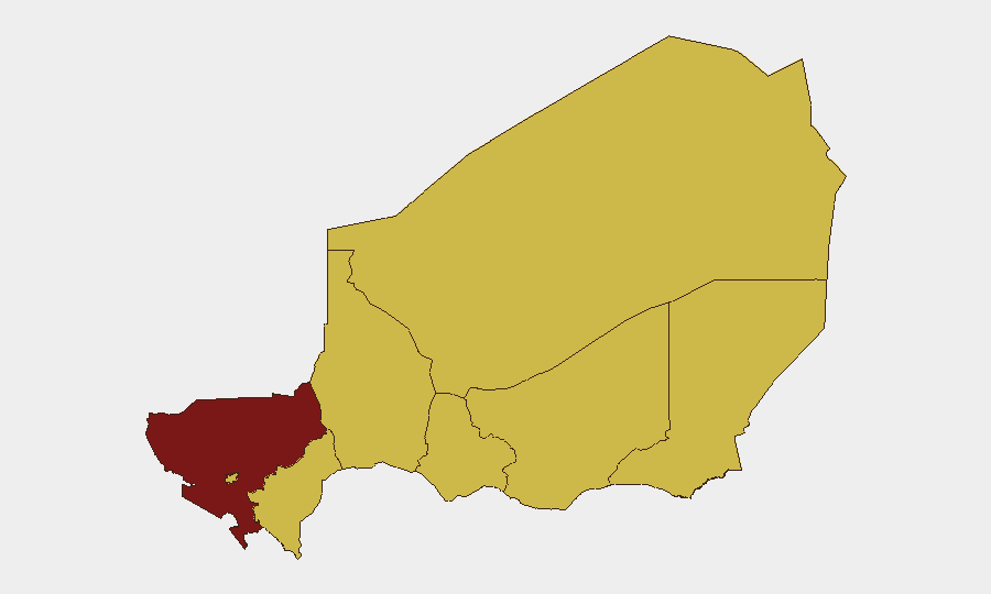
Niger remains the 10th-highest-threat country globally, with 11 tracked security events recorded in the past reporting cycle. The security environment is fragmented by region: Tillabéri Region (bordering Mali) poses the highest composite risk (100), while seven other regions and the capital, Niamey, each carry elevated threat levels (70). Recent signal activity points to political friction and civil grievances alongside ongoing counterterrorism operations, but substantive incident data for the final 48 hours of this reporting period remains limited in open sources.
Key Developments
Note on data constraints: GeoBit's live web research has not yet surfaced corroborated, time-stamped security or unrest incidents in Niger for June 27–28, 2026. The most recent confirmed event on record is the June 18 attack on Diori Hamani International Airport in Niamey, which resulted in military and civilian fatalities and 22 confirmed attacker deaths—now 10 days historical and outside the 48-hour window. Subsequent signal activity (demands, investigations, public statements, and disapprovals recorded June 26–28) suggests ongoing political or administrative tensions, possibly linked to the airport incident response or broader governance friction, but specific incident details, casualty counts, and locations remain unconfirmed in available feeds.
Recommendation: Security teams with personnel or assets in Niger should cross-reference this brief with real-time government travel advisories, UN OCHA situation reports, and dedicated OSINT monitoring to capture the latest tactical developments.
Highest-Risk Areas
Tillabéri Region dominates the risk profile (score 100), driven by its proximity to jihadist sanctuaries in Mali and a long history of cross-border militant activity. Agadez, Zinder, Diffa, and Tahoua Regions each register score 70, reflecting persistent pressure from armed groups—particularly in Diffa's Lake Chad basin, where Boko Haram and splinter factions operate. The capital, Niamey (score 70), has moved into the highest-risk tier, signaling that security concerns now extend beyond the periphery to government and civilian infrastructure in the urban core, as evidenced by the June 18 airport attack. Dosso and Maradi Regions, while lower in absolute ranking, remain watch areas given their connectivity to smuggling networks and regional instability.
How GeoBit Would Assist
Security teams should deploy AOI Monitoring & Early Warning on Tillabéri, Agadez, Diffa, and Niamey to trigger alerts on armed group movements, military operations, or civilian incidents within defined perimeters. Intel Sweep and multi-language OSINT fusion (including X/Twitter and Telegram monitoring, YouTube intelligence, and local media) would provide near-real-time corroboration of emerging threats and civil unrest. Network & Actor Analysis applied to jihadist and political figures active in Niger enables predictive flagging of operational tempo shifts or factional realignment that could affect travel corridors and asset security.
7-Day Outlook
Political tensions (evidenced by recent demands and investigations) appear to be running parallel to counterterrorism operations in the north, creating a complex risk picture. Expect continued military activity in Tillabéri and Diffa; security teams should assume restricted access to those regions and elevated checkpoint friction on main routes. If the signal activity (June 26–28) reflects escalating civil grievances or inter-agency disputes, secondary volatility in Niamey cannot be ruled out, reinforcing the need for continuous monitoring and contingency planning for urban-based personnel.
Highest-Risk Areas — Ranked
| # | State / Region | Risk |
|---|---|---|
| 1 | Tillabéri Region | 100 |
| 2 | Agadez Region | 70 |
| 3 | Zinder Region | 70 |
| 4 | Diffa Region | 70 |
| 5 | Niamey | 70 |
| 6 | Tahoua Region | 70 |
| 7 | Dosso Region | 70 |
| 8 | Maradi Region | 70 |
Sources
Previous Daily Briefs
A new Niger brief is written every day — each with its own risk map and downloadable CSV. Here's the last week; use the calendar to go further back.
📅 Browse every day by calendar →
Highlighted days have a brief. Tap a day for that day's map & analysis, or “csv” for that day's dataset ($5).