Situation Summary
Oman is experiencing acute maritime security degradation due to escalating Iran–US–UK military activity in the Arabian Sea and Gulf of Oman, with multiple tanker strikes and projectile attacks reported in the last 48 hours concentrated near Musandam and Duqm. Civilian transport safety incidents (two road accidents with 23 casualties combined) compound the risk picture ashore. The overall threat composite remains moderate (score 38, rank #null globally), but Al Wusta Governorate—home to critical maritime chokepoints and Duqm port—is now classified as substantially higher risk (31.3) than the rest of the country, signaling concentration of acute hazard in a strategically vital corridor.
Key Developments
- Arabian Sea, ~100 km east of Duqm (Al Wusta), July 19–20: Commercial oil tanker struck during confirmed "intense military activity"; UK Maritime Trade Operations (UKMTO) investigating. At least three tanker incidents reported in regional sea corridors in the same 48-hour window.
- Off Khasab, Musandam Governorate, 19 nm east (July 19–20): Tanker hit by unidentified projectile; minor port-side structural damage reported. Crew safe; vessel proceeding to next port under investigation.
- Northwest Kumzar, Musandam, 8 nm offshore (July 19–20): Vessel struck by unknown projectile, caught fire, and went adrift. Crew recovered safely by tug; fire ongoing, no environmental impact confirmed.
- Omani territorial and maritime approaches (July 19–20): Iran's Islamic Revolutionary Guard Corps (IRGC) publicly claimed targeting of US maritime surveillance radar in Oman amid coordinated Iran–UK–US naval operations near Musandam and Duqm sea lanes.
- Gulf of Oman, Greek-owned tankers (July 19–20): Multiple Greek-flagged vessels attacked in separate incidents. Seven Greek seafarers reported safe; vessels sustaining damage. Parallel reports of similar incidents in Black Sea.
- Qarn al Alam area, interior Oman (July 19–20): Royal Oman Police reported road accident; two killed, five injured.
- Suhar, North Al Batinah Governorate (July 19–20): Passenger bus crash injured 18 people on a major coastal transport corridor.
Highest-Risk Areas
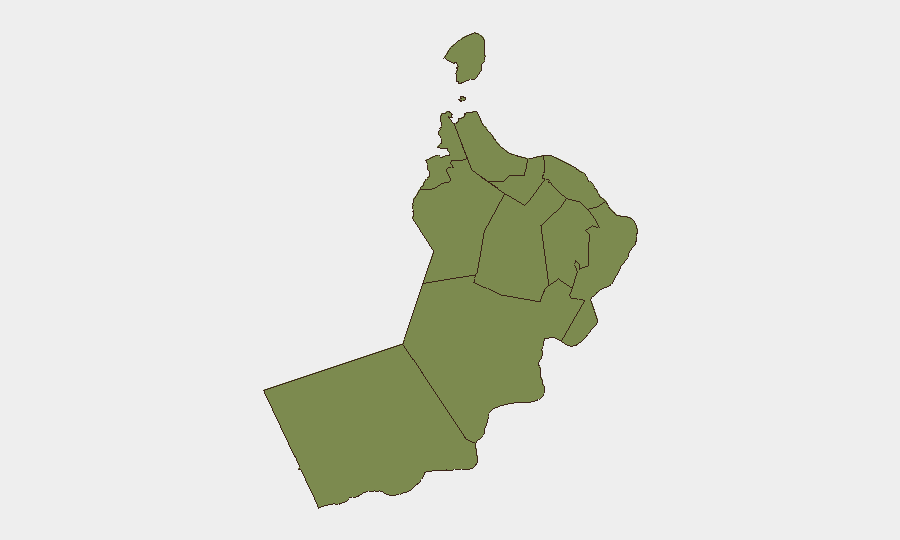
Al Wusta Governorate dominates risk assessment (31.3 vs. 4.3 for Muscat), driven by its position as the epicenter of current maritime attack activity and proximity to critical shipping chokepoints near Duqm. Musandam Governorate (risk 2.0), though lower-ranked, is equally significant operationally—three of the four specific tanker-strike incidents occurred in its territorial waters or immediate approaches, positioning it as a secondary hotspot for projectile attacks and military escalation. All other governorates remain at baseline risk (1.3–2.0), reflecting concentration of acute hazard in maritime and coastal transport corridors rather than internal instability. Risk elevation is primarily external (regional military activity) rather than domestic political or security dysfunction.
How GeoBit Would Assist
Security teams with Oman operations should deploy Maritime & Aviation Tracking with real-time vessel monitoring and AOI Monitoring & Early Warning on Musandam and Al Wusta governorates to detect attack clusters before they impact corporate supply chains. OSINT Fusion & Corroboration (X/Telegram feeds, news feeds, UKMTO advisories) combined with Conflict & Military tracking of IRGC, UK, and US force posture enables early tactical warning of escalation windows. Routing & Network Analysis should be used immediately to evaluate alternative maritime and land routes for personnel and cargo transiting Oman, with GIS & Spatial Analysis pinpointing safer transit corridors outside Al Wusta and Musandam.
7-Day Outlook
Elevated maritime attack frequency is likely to persist through late July as Iran–US–UK tensions remain unresolved; shipping insurers and operators should anticipate continued incident clustering near Duqm and Khasab. Onshore, routine transport accidents and minor security incidents may continue at baseline levels. Risk trajectory depends on diplomatic or military de-escalation signals; absent those, maritime-focused companies and vessels should plan for extended high-risk operations in Gulf of Oman approaches.
Highest-Risk Areas — Ranked
| # | State / Region | Risk |
|---|---|---|
| 1 | Al Wusta Governorate | 31.3 |
| 2 | Muscat Governorate | 4.3 |
| 3 | Musandam Governorate | 2 |
| 4 | Dhofar Governorate | 2 |
| 5 | Al Buraymi Governorate | 1.3 |
| 6 | Ad Dhahirah Governorate | 1.3 |
| 7 | Al Batinah North Governorate | 1.3 |
| 8 | Al Batinah South Governorate | 1.3 |
| 9 | Ad Dakhiliyah Governorate | 1.3 |
| 10 | Ash Sharqiyah North Governorate | 1.3 |
| 11 | Ash Sharqiyah South Governorate | 1.3 |
Sources
Previous Daily Briefs
A new Oman brief is written every day — each with its own risk map and downloadable CSV. Here's the last week; use the calendar to go further back.
📅 Browse every day by calendar →
Highlighted days have a brief. Tap a day for that day's map & analysis, or “csv” for that day's dataset ($5).
Atlas — our AI intelligence desk — emails them this snapshot personally. Nothing else, no list.