Situation Summary
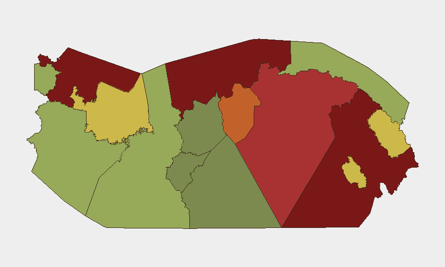
Panama's national threat ranking remains stable at #50 globally (composite score 35), with crime and gang violence as the primary driver. However, four sub-national regions—Darién, Colón, Bocas del Toro, and Panamá Province—present substantially elevated risks (scores 78–95), reflecting concentrated trafficking, territorial gang disputes, and limited state presence. The period 10–15 August saw a cluster of homicides in metropolitan Panama (Panamá Oeste, Coclé) and continued large-scale security operations along the Colombian border, indicating active violence and policy responses rather than de-escalation.
Key Developments
- Antón cabecera & Río Hato (Coclé) – Curfew for Minors (14 Aug 2026)
Mayor Eric Domínguez signed Decreto Alcaldicio N.º 18-26, imposing a nightly curfew (20:00–05:00) on persons under 18 in response to youth firearm violence. Enforcement began 14 August and will remain in effect indefinitely; exceptions include work, school, and supervised transit. Corporate teams with younger staff or family members should plan night movements accordingly.
- San Miguelito District (Panamá Province) – Potential Mobility Restrictions (14–15 Aug 2026)
Authorities are considering re-imposing extraordinary mobility restrictions (similar to existing curfews in Colón and previous San Miguelito measures) due to rising youth-involved armed crime. No formal decree has been issued as of 15 August, but announcement signals heightened local concern and possible imminent enforcement.
- Metropolitan Homicide Cluster (Panamá Oeste, Coclé) (10–13 Aug 2026)
Four reported deaths within 24 hours (13 Aug) in Villa Unida and surrounding corregimientos; incidents include inter-gang crossfire (balacera), targeting of minors (16- and 18-year-olds), and a killing in Puerto Pilón Centro (Colón). Pattern consistent with territorial disputes and indicates active gang violence in densely populated areas east and south of Panama City.
- Operation Escudo de Acero (Darién Border) – Ongoing (deployed 9 Aug, active through mid-Aug 2026)
Panama deployed ~700 security personnel to reinforce the Colombia border, targeting drug trafficking, illegal mining, and Clan del Golfo networks. Checkpoints, patrols, and armed confrontations remain likely for any travel near the Darién jungle frontier.
- Santo Domingo Water Infrastructure Vandalism (Las Tablas, Los Santos) (14 Aug 2026)
IDAAN reported sabotage to three of nine water sources affecting ~300 residents. Indicates localized critical-infrastructure vulnerability; short-term supply disruption likely for residents and transiting personnel.
- Tocumen Airport Criminal-Record Screening (14 Aug 2026)
Migration authorities denied transit to a Trinidad and Tobago national with recorded sexual offences conviction. Reflects active use of criminal-history databases at Panama's primary international gateway; travelers with serious prior convictions may face entry denial or extended screening.
Highest-Risk Areas
Darién (95) and Colón (88) dominate the risk landscape, driven by trafficking throughput, limited state control, and organized-crime competition. Bocas del Toro (82) and Panamá Province (78) extend risk into maritime and urban corridors. The cluster reflects geographic proximity to Colombia, the Caribbean transit zone, and the Canal—all high-value targets for drug organizations and smuggling networks. Metropolitan areas (Panamá Oeste, San Miguelito) show rising youth-gang homicides and are now responding with curfews, indicating localized instability spreading from peripheral zones toward population centers.
How GeoBit Would Assist
Security teams should deploy AOI Monitoring & Early Warning on Darién checkpoints, San Miguelito corregimientos, and Tocumen arrivals to flag new curfews, roadblocks, or incident patterns. Network & Actor Analysis and Intel Sweep (X/Twitter, local news) can track gang territorial changes and emerging restrictions faster than official channels. Routing & Network Analysis supports real-time journey planning around active curfew zones and Operation Escudo de Acero checkpoints.
7-Day Outlook
Curfew enforcement in Antón and potential adoption of restrictions in San Miguelito will likely increase police interactions and nighttime mobility friction through late August. Gang-related homicides in Panamá Oeste show no sign of de-escalation; continued police and military operations in Darién will sustain border-zone operational tempo. Monitor local media and municipal announcements for new curfew decrees or checkpoints in the next 72 hours.
Highest-Risk Areas — Ranked
| # | State / Region | Risk |
|---|---|---|
| 1 | Darién | 95 |
| 2 | Colón | 88 |
| 3 | Bocas del Toro | 82 |
| 4 | Panamá Province | 78 |
| 5 | Panamá Oeste | 75 |
| 6 | Ngäbe-Buglé | 68 |
| 7 | Emberá-Wounaan | 62 |
| 8 | Veraguas | 58 |
| 9 | Chiriquí | 48 |
| 10 | Naso Tjër Di | 45 |
| 11 | Guna Yala | 42 |
| 12 | Coclé | 35 |
Sources
Previous Daily Briefs
A new Panama brief is written every day — each with its own risk map and downloadable CSV. Here's the last week; use the calendar to go further back.
- August 16, 2026
- August 15, 2026
- August 14, 2026
- August 13, 2026
- August 12, 2026
- August 11, 2026
- August 10, 2026
📅 Browse every day by calendar →
Highlighted days have a brief. Tap a day for that day's map & analysis, or “csv” for that day's dataset ($5).
Atlas — our AI intelligence desk — emails them this snapshot personally. Nothing else, no list.