Situation Summary
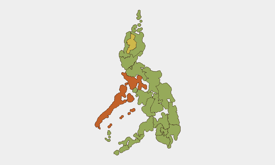
The Philippines remains at moderate composite threat level (rank #36 globally, score 63) with a stable operational security environment over the past 24–48 hours. No verified crime, civil unrest, armed conflict, or infrastructure disruption incidents have been reported in the last two days; the country's threat profile is currently driven by political and governance tensions rather than acute security incidents. Sub-national risk concentration remains high in Mimaropa, Cordillera, and Davao regions, where longstanding armed-group activity and resource-conflict dynamics persist.
Key Developments
No new, verified security or travel-risk incidents have been publicly reported in the Philippines within the last 24–48 hours that meet evidentiary and recency thresholds for inclusion in this brief. Open-source monitoring confirms an absence of confirmed crime, unrest, or conflict events dated to 14–16 July 2026.
Recent event signals captured by GeoBit (13–15 July) reflect political and governance activity—presidential disapproval statements, judicial proceedings, international diplomatic tensions, and media/company public statements—rather than emergent physical-security threats. Small-arms incidents attributed to conservationist vs. Philippine force interactions and earlier Cotabato City shootings occurred prior to the 24–48 hour window and are noted here for operational awareness but do not constitute current developments.
Security teams with personnel or assets in-country should continue routine monitoring of Mimaropa and Cordillera regions, where composite risk scores exceed 70 and 62 respectively.
Highest-Risk Areas
Mimaropa (risk 74) and Cordillera Administrative Region (risk 62.6) drive national sub-national risk, followed by Davao Region (58.4) and Metro Manila (57.8). These areas reflect persistent armed-group presence, resource-conflict dynamics (particularly in mining and conservation zones), and in Metro Manila's case, urban crime and political tensions. Davao and Cordillera maintain elevated risk from New People's Army activity and tribal/land-dispute armed groups; Mimaropa's high score reflects piracy, smuggling networks, and weak state presence across island geography. Metro Manila's risk, while lower in absolute terms, concentrates population and economic assets, making it operationally significant for corporate duty-of-care.
How GeoBit Would Assist
Security teams should deploy AOI Monitoring & Early Warning on high-risk provinces (Mimaropa, Cordillera, Davao) with persistent alerting for armed-group activity, civil unrest, and crime indicators. Intel Sweep and multi-language OSINT across social media, local news, and radio SIGINT can detect emerging governance crises, protests, or security incidents in real time. Routing & Network Analysis enables alternative-route planning for personnel movement in Cordillera and Davao, minimizing exposure to known armed-group zones; Conflict & Military force-structure tracking provides updated positions and capabilities of non-state actors operating in high-risk regions.
7-Day Outlook
No significant escalation in acute security incidents is currently forecast for the next seven days. Political and diplomatic tensions will likely remain the dominant signal driver; monitoring of Cordillera and Davao should continue at standard vigilance levels. Monsoon season activity and weather-related incidents (landslides, flooding) in Mindanao remain a secondary operational concern independent of conflict dynamics.
Highest-Risk Areas — Ranked
| # | State / Region | Risk |
|---|---|---|
| 1 | Mimaropa | 74 |
| 2 | Cordillera Administrative Region | 62.6 |
| 3 | Davao Region | 58.4 |
| 4 | Metro Manila | 57.8 |
| 5 | Negros Island Region | 54.2 |
| 6 | Soccsksargen | 44.6 |
| 7 | Ilocos Region | 44.6 |
| 8 | Central Luzon | 44.6 |
| 9 | Bicol Region | 44.6 |
| 10 | Central Visayas | 44.6 |
| 11 | Bangsamoro | 44 |
| 12 | Caraga | 44 |
Sources
Previous Daily Briefs
A new Philippines brief is written every day — each with its own risk map and downloadable CSV. Here's the last week; use the calendar to go further back.
📅 Browse every day by calendar →
Highlighted days have a brief. Tap a day for that day's map & analysis, or “csv” for that day's dataset ($5).
Atlas — our AI intelligence desk — emails them this snapshot personally. Nothing else, no list.