Situation Summary
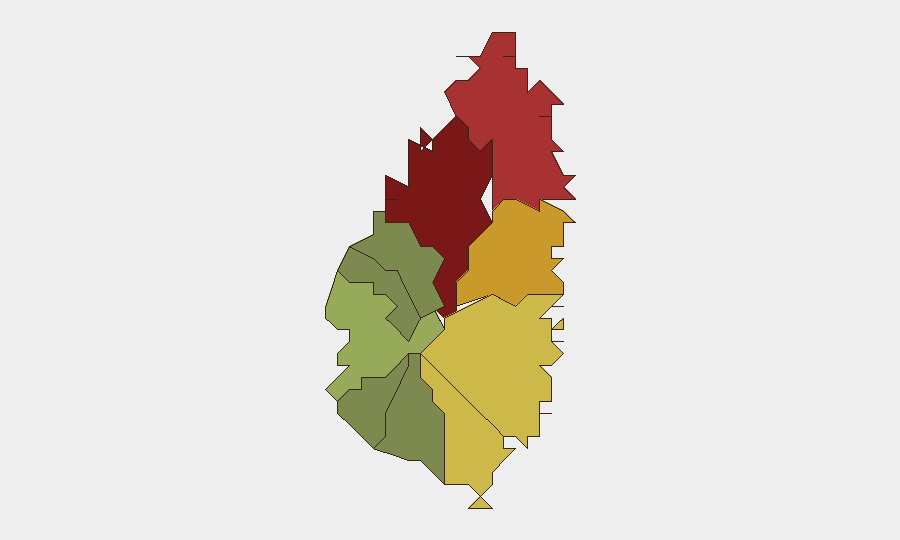
Saint Lucia remains a low-threat jurisdiction globally (rank #163; composite score 6) with no discrete security events recorded in GeoBit's tracking window. However, the past week has surfaced elevated transport-safety risk, a governance process affecting maritime confidence, and evidence of Saint Lucian involvement in regional narcotics networks. The capital and northern districts (Castries, Gros Islet) continue to drive national risk concentration, driven by persistent urban crime and gang activity rather than acute incident spikes.
Key Developments
- Multi-casualty road collision, Millennium Highway (Castries), Friday 4 September — Two-vehicle crash injured nine people; one driver required extrication. Incident on major transport artery signals ongoing road-safety risk and potential travel disruption.
- Minibus crash, Pierrot (Vieux Fort), Friday 4 September — Vehicle veered off road and struck wall; two adult casualties treated and transported. Second significant transport incident within 24 hours.
- Commission of Inquiry into deadly boat collision commences, 8 September — Mario Michel appointed to lead inquiry (running through March 2027) into a prior fatal maritime collision. Process addresses institutional accountability and may influence public confidence in marine-transport safety.
- Police Commissioner reiterates firearm-licence revocation power, 3–4 September — Commissioner Verne Garde publicly stated that licences can be revoked immediately for misuse, following viral video of businessman brandishing gun. Reflects enforcement messaging on unlicensed weapons use and personal security.
- "Not sustained" investigative finding clarified by Police Welfare Association, 4 September — Public statement by Sergeant Ann Joseph on investigation involving Minister Richard Frederick; emphasized that "not sustained" does not mean allegations are false or closed permanently. Signals rule-of-law perception concerns regarding elite accountability.
- Two Saint Lucian nationals arrested in major cocaine seizure, Trinidad and Tobago, 2–3 September — Trinidad and Tobago Police Service seized ~416.5 kg cocaine (US$28.7M) in Longdenville; three arrested, two Saint Lucian nationals aged 37 and 38. Highlights organized-crime links across regional networks.
- Taiwan enhances RSLPF cybercrime and police capacity, reported 3–4 September — Saint Lucian police officers attended Taiwan workshops on cybercrime prevention and AI literacy; new technology transfer underway. Reflects capacity-building in investigative and digital-surveillance domains.
- Pigeon Island National Landmark closed for renovations, announced 3 September, active through September — Temporary public closure in Gros Islet for month-long infrastructure work; affects tourism and northern-area access.
Highest-Risk Areas
Castries (risk 95) and Gros Islet (risk 78) dominate the national threat profile, reflecting persistent urban crime, gang activity, and informal-economy friction in the capital and northern tourism zones. Dennery (72), Vieux Fort (68), and Micoud (65) form a secondary risk band, likely driven by drug-transit vulnerabilities and localized criminal networks. Southern and western parishes (Laborie, Choiseul, Anse La Raye, Canaries) remain significantly lower-risk, suggesting geographic concentration of organized-crime and violent-crime drivers in urban and eastern corridors.
How GeoBit Would Assist
Security teams should employ Intel Sweep and web-OSINT monitoring to track transport-safety incidents, police investigations, and political-accountability narratives that affect operational confidence. AOI Monitoring with alerting on Castries and Gros Islet would provide early warning of crime spikes, demonstrations, or port/maritime disruptions. Network & Actor Analysis would map Saint Lucian involvement in transnational narcotics and firearms networks, enabling risk contextualization for personnel and supply-chain movements.
7-Day Outlook
Road-safety risk remains elevated; transport operators and travelers should anticipate periodic congestion and incident response on main corridors. The maritime commission process will gradually clarify governance gaps; no acute marine-transport closure is imminent. Regional narcotics enforcement activity signals sustained criminal-network presence but does not indicate destabilization of Saint Lucia's internal security environment in the near term.
Highest-Risk Areas — Ranked
| # | State / Region | Risk |
|---|---|---|
| 1 | Castries | 95 |
| 2 | Gros Islet | 78 |
| 3 | Dennery | 72 |
| 4 | Vieux Fort | 68 |
| 5 | Micoud | 65 |
| 6 | Soufrière | 42 |
| 7 | Laborie | 38 |
| 8 | Choiseul | 35 |
| 9 | Anse La Raye | 28 |
| 10 | Canaries | 12 |
Sources
- stluciatimes.com
- martinique.franceantilles.fr
- stluciatimes.com
- ground.news
- ground.news
- saintluciadailypost.com
- htsstlucia.org
- asianexpressbd.com
- asianexpressbd.com
- saintluciadailypost.com
- stluciatimes.com
- pulsefeed.lk
- nltimes.nl
- pnghausbung.com
- saintluciadailypost.com
- stluciatimes.com
- stluciatimes.com
- stluciatimes.com
Previous Weekly Briefs
A new Saint Lucia brief is written every Monday, covering the week — each with its own risk map and downloadable CSV. Use the calendar to go further back.
- September 3, 2026
- August 31, 2026
- August 29, 2026
- August 26, 2026
- August 24, 2026
- August 22, 2026
- August 20, 2026
📅 Browse past briefs by calendar →
Highlighted days have a brief. Tap a day for that day's map & analysis, or “csv” for that day's dataset ($5).
Atlas — our AI intelligence desk — emails them this snapshot personally. Nothing else, no list.