Situation Summary
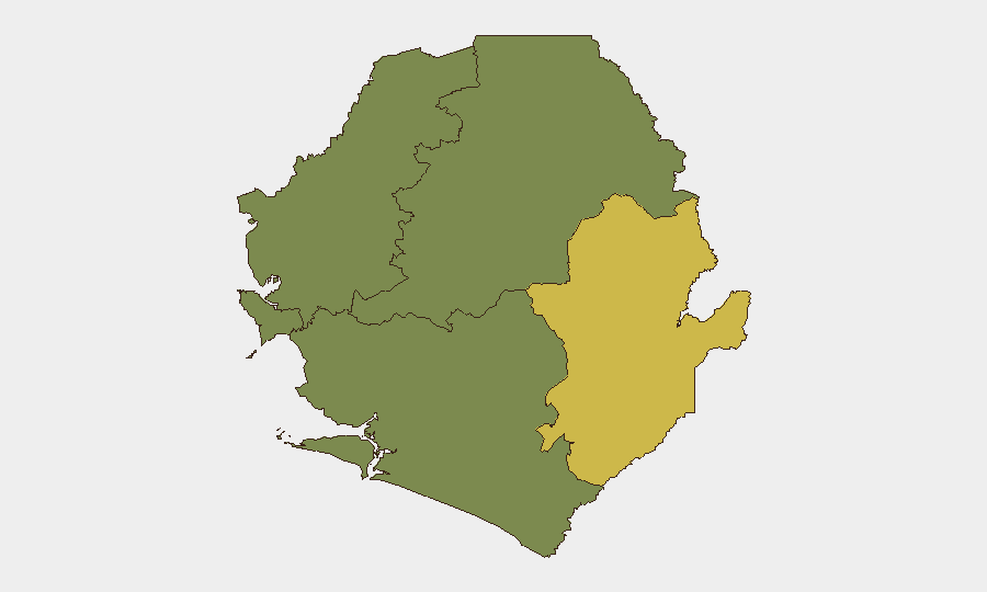
Sierra Leone remains a low-threat environment globally (#103 composite score) with minimal confirmed incident activity in the past 24–48 hours. The security landscape is heavily concentrated in the Eastern Province, which accounts for the majority of national risk exposure. Overall stability appears sustained, though localized vulnerabilities in resource-extraction regions and cross-border areas warrant continued monitoring.
Key Developments
- No confirmed security or instability incidents reported in the last 24–48 hours. Live web research did not surface any verified arrests, protests, violent crime, infrastructure disruptions, or official travel advisories from Sierra Leone in the current window.
- Freetown (9 Jul 2026) — A high-profile fraud case involving defendants Admire and Dausy was adjourned by Magistrate Mustapha Braima; uncorroborated via social media source and not indicative of broader security degradation.
- Planned domestic violence and human rights conference scheduled (9 Jul 2026) — A national conference on domestic violence, human rights, and policy reform proceeded as scheduled; a convening event rather than a security incident.
Highest-Risk Areas
Eastern Province dominates the national risk profile (composite score 68), significantly outpacing all other regions. This concentration reflects known vulnerabilities associated with artisanal and small-scale mining activity, cross-border trafficking, and limited state presence in remote districts. Western Area (score 35)—which includes the capital Freetown and surrounding urban zones—ranks second, driven primarily by urban crime and petty theft patterns typical of major African urban centers. The three remaining provinces (Northern, North West, and Southern) register minimal tracked risk, indicating either lower incident frequency, better security infrastructure, or reduced reporting density. Organizations with personnel or operations in Eastern Province should apply heightened due-diligence protocols; those in Freetown should maintain standard urban-area precautions.
How GeoBit Would Assist
Security teams should deploy AOI Monitoring & Early Warning on Eastern Province mining zones and cross-border transit corridors to detect emerging trafficking, labor, or conflict signals before escalation. Intel Sweep and multi-language OSINT fusion (targeting local media, radio SIGINT, and social platforms) will improve detection of localized crime, protest, or instability events that may not surface in English-language reporting. Risk & Threat Assessment and Network & Actor Analysis capabilities enable systematic tracking of criminal and trafficking networks that operate across provincial boundaries, informing route planning and personnel movement decisions.
7-Day Outlook
No acute security deterioration is anticipated in the near term. Continued monitoring of Eastern Province for trafficking activity and resource-sector labor disputes remains prudent, particularly given seasonal patterns in artisanal mining. Routine security posture (residential area awareness, transport vetting, and periodic vulnerability assessments in Freetown) is sufficient for most corporate operations.
Highest-Risk Areas — Ranked
| # | State / Region | Risk |
|---|---|---|
| 1 | Eastern Province | 68 |
| 2 | Western Area | 35 |
| 3 | North West Province, Sierra Leone | 0 |
| 4 | Northern Province, Sierra Leone | 0 |
| 5 | Southern Province, Sierra Leone | 0 |
Previous Daily Briefs
A new Sierra Leone brief is written every day — each with its own risk map and downloadable CSV. Here's the last week; use the calendar to go further back.
📅 Browse every day by calendar →
Highlighted days have a brief. Tap a day for that day's map & analysis, or “csv” for that day's dataset ($5).
Atlas — our AI intelligence desk — emails them this snapshot personally. Nothing else, no list.