Situation Summary
Solomon Islands remains a low-incident environment in the 24–48 hour window (21–22 August 2026), with no corroborated reports of civil unrest, armed clashes, major crime events, or infrastructure failures. The country's composite threat score of 7 (ranked #145 globally) reflects chronic underlying vulnerabilities—gang activity and maritime-security concerns in Honiara and Guadalcanal, historical communal tensions, and limited state capacity—rather than acute destabilization. No new developments in the last 48 hours suggest imminent escalation of these baseline risks.
Key Developments
No corroborated incidents reported in Solomon Islands in the last 24–48 hours (21–22 August 2026).
Open-source monitoring across news wires, Pacific-focused outlets, and security-briefing platforms has identified no discrete events meeting incident criteria: no protests, riots, armed conflict, terror attacks, political instability declarations, or critical infrastructure failures in this window. Recent regional coverage of Solomon Islands (mid-August onwards) focuses on routine governance activities (tax consultations, Pacific Islands Forum participation) and planned maritime law-enforcement operations (fisheries surveillance, Forum Fisheries Agency coordination), all conducted without reported confrontations or escalation affecting civilian safety or movement.
Analysts should note: absence of reported incidents does not imply absence of underlying tension. Historical context shows sporadic gang violence in Honiara, inter-provincial resource disputes, and logistical vulnerabilities in outer islands; these baseline risks persist regardless of recent event silence.
Highest-Risk Areas
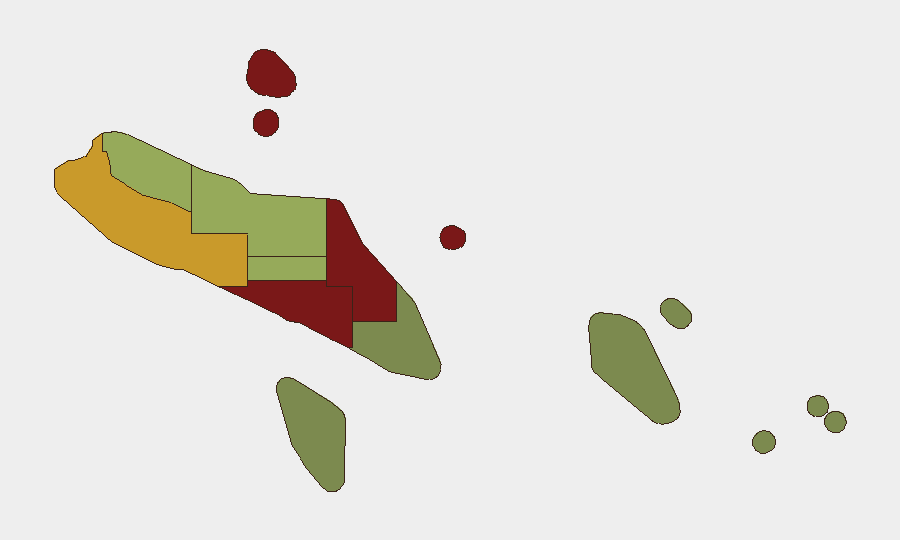
Honiara (risk score 92) and Guadalcanal (88) dominate the country's threat profile, driven by gang-related crime, informal-settlement expansion, and police-capacity constraints in the capital and surrounding province. Malaita (85) carries significant communal-violence risk tied to historical inter-island tensions and resource competition. Western Province (72) faces maritime and cross-border security concerns, including piracy and irregular maritime migration routes. Combined, these four zones account for the majority of Solomon Islands' documented security incidents over the past 12 months; outer provinces (Temotu, Rennell and Bellona) remain comparatively low-risk but less frequently monitored.
How GeoBit Would Assist
Security teams should leverage Intel Sweep and global event feeds configured with Solomon Islands–specific keywords and geographic filters to detect any emergence of civil unrest, crime spikes, or political instability within 4–6 hours of occurrence. AOI Monitoring & Early Warning on Honiara CBD, port facilities, and government quarters enables persistent watch for crowd gathering, unusual security deployments, or infrastructure damage. Network & Actor Analysis applied to known gang-affiliated individuals and protest organizers on social media (X, Telegram, local platforms) provides leading indicators of planned violence or demonstrations before they materialize. Combined with multi-language search (Pijin, English) and sentiment analysis of local media, these tools allow near-real-time risk escalation alerts.
7-Day Outlook
No intelligence suggests new security shocks in the next seven days. Risk trajectory remains flat, contingent on absence of triggering events (major criminal incident, political controversy, natural disaster affecting infrastructure). Security teams should maintain baseline vigilance on Honiara and Guadalcanal; duty-of-care protocols (staff check-ins, travel-approval processes, emergency-contact updates) remain appropriate and proportionate to the country's composite threat level.
Highest-Risk Areas — Ranked
| # | State / Region | Risk |
|---|---|---|
| 1 | Honiara | 92 |
| 2 | Guadalcanal | 88 |
| 3 | Malaita | 85 |
| 4 | Western | 72 |
| 5 | Choiseul | 58 |
| 6 | Isabel | 52 |
| 7 | Central Province | 48 |
| 8 | Makira-Ulawa | 38 |
| 9 | Rennell and Bellona | 22 |
| 10 | Temotu | 18 |
Sources
Previous Daily Briefs
A new Solomon Islands brief is written every day — each with its own risk map and downloadable CSV. Here's the last week; use the calendar to go further back.
- August 20, 2026
- August 18, 2026
- August 16, 2026
- August 14, 2026
- August 12, 2026
- August 10, 2026
- August 8, 2026
📅 Browse every day by calendar →
Highlighted days have a brief. Tap a day for that day's map & analysis, or “csv” for that day's dataset ($5).
Atlas — our AI intelligence desk — emails them this snapshot personally. Nothing else, no list.