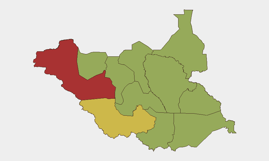
Situation Summary
South Sudan remains in a state of chronic instability driven by ethnic violence and fragmented armed-group activity, with a composite threat score of 67 placing it at #17 globally. The conflict landscape is characterized by competition between the SSPDF and SPLA-IO factions, inter-communal clashes, and localized banditry across multiple states. Recent administrative and diplomatic signals (noted in 2026-07-21 event logs) suggest elevated political tension, though no major kinetic escalation has been independently verified in the past 24–48 hours. The security environment remains volatile and personnel/asset exposure across non-capital regions carries substantial risk.
Key Developments
Data Integrity Note: Web research covering the past 24–48 hours has not yielded independently time-stamped incidents specific to South Sudan within 2026-07-21 to 2026-07-22. Available reporting relates to:
- Broader Sudan (not South Sudan) conflicts, or
- Earlier 2025–early 2026 clashes (Jonglei SSPDF–SPLA-IO escalations dating to December 2025–January 2026; Nasir helicopter incident referenced in past-tense context).
Event Signals (2026-07-21): Platform event feeds registered public statements, administrative sanctions affecting schools/hospitals, military-force activity, and interstate diplomatic disapproval (involving Egypt/Nile-related statements). These signals do not yet carry corroborated geographic or operational detail.
Recommendation: Corporate security teams should monitor UNMISS press releases, local Juba media, and verified South Sudan–focused social channels for real-time incident confirmation; GeoBit's event feeds will be updated as incidents are cross-verified.
Highest-Risk Areas
Western Bahr el Ghazal State (76.6) is the single highest-risk region, driven by ongoing ethnic militia activity and resource competition. Western Equatoria (60.5) follows, reflecting instability in the southwestern corridor and cross-border pressures. Upper Nile (53.5) remains volatile due to sustained SSPDF–SPLA-IO competition and localized communal conflict. The majority of remaining states (Northern Bahr el Ghazal, Ruweng, Unity, Warrap, Lakes, Jonglei, Greater Pibor, Central Equatoria, Eastern Equatoria) cluster at 46.6, indicating widespread mid-to-high baseline risk. All non-capital deployments should assume elevated threat levels; travel outside secure compounds requires threat assessment and armed escort coordination.
How GeoBit Would Assist
Persistent Monitoring & Early Warning: Area-of-Interest (AOI) monitoring with alerting on high-risk states (Western Bahr el Ghazal, Western Equatoria, Upper Nile) enables real-time notification of clashes, checkpoints, and movement by armed groups.
Route & Journey Planning: Routing and Network Analysis tools identify safe corridors and alternative pathways for personnel movement, accounting for current conflict zones and checkpoint locations.
Conflict & Force Intelligence: Battle mapping and force-structure tracking of SSPDF, SPLA-IO, and militia positions enable security teams to assess operational risk around specific asset locations or movement corridors.
Multi-Source OSINT: Intel Sweep combining X/Twitter, radio SIGINT, YouTube monitoring, and entity extraction provide 24/7 situational awareness beyond official channels and fill gaps in verified reporting.
7-Day Outlook
No major shift in the overall conflict trajectory is anticipated over the next 7 days; state-level ethnic and factional clashes are likely to persist at baseline levels. The 2026-07-21 diplomatic signals and administrative actions warrant close observation for secondary escalation, particularly if accompanied by military repositioning or formal statements by SSPDF leadership. Personnel in Western Bahr el Ghazal, Western Equatoria, and Upper Nile should maintain heightened alert posture and consider contingency evacuation protocols.
Highest-Risk Areas — Ranked
| # | State / Region | Risk |
|---|---|---|
| 1 | Western Bahr el Ghazal State | 76.6 |
| 2 | Western Equatoria | 60.5 |
| 3 | Upper Nile | 53.5 |
| 4 | Northern Bahr el Ghazal | 46.6 |
| 5 | Ruweng Administrative Area | 46.6 |
| 6 | Unity | 46.6 |
| 7 | Warrap | 46.6 |
| 8 | Lakes | 46.6 |
| 9 | Jonglei | 46.6 |
| 10 | Greater Pibor Administrative Area | 46.6 |
| 11 | Central Equatoria | 46.6 |
| 12 | Eastern Equatoria | 46.6 |
Sources
Previous Daily Briefs
A new South Sudan brief is written every day — each with its own risk map and downloadable CSV. Here's the last week; use the calendar to go further back.
📅 Browse every day by calendar →
Highlighted days have a brief. Tap a day for that day's map & analysis, or “csv” for that day's dataset ($5).
Atlas — our AI intelligence desk — emails them this snapshot personally. Nothing else, no list.