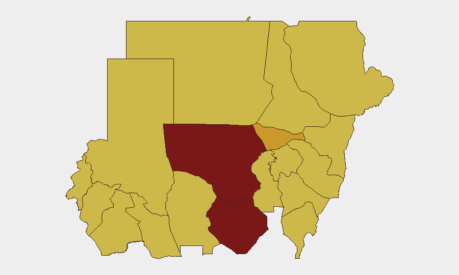
Situation Summary
Sudan remains in active civil war with intensifying multi-front combat across North Kordofan, South Kordofan, and secondary theaters in Darfur and Blue Nile states. Over the past 48 hours, UN assessments have flagged significant escalation around El Obeid (North Kordofan) involving drone strikes on civilian infrastructure and coordinated ground operations. The conflict is increasingly characterized by drone employment against transport corridors and populated centers, with humanitarian access degrading. Trajectory remains upward; no de-escalation indicators are present.
Key Developments
- El Obeid, North Kordofan (26–29 June): UN officials issued warnings of intensified drone strikes and ground fighting, with risk assessment of wider assault on the city and severe civilian harm. Reported targets included power, water, fuel, and displacement-site infrastructure.
- Kordofan region multi-front fighting (26–29 June): Combat escalated across Dilling, Kadugli, and Babanusa in parallel with El Obeid operations, indicating coordinated pressure by one or more parties on multiple axes.
- Transport corridor disruption (recent weeks, reiterated 26–29 June): Drone strikes on bridges and road networks in Kordofan and Darfur corridors have isolated communities and severely constrained humanitarian movement.
- Blue Nile and White Nile volatility (recent days, current): Clashes in Kurmuk, Geissan, and Bau reported as ongoing, with parties contesting territorial control in resource-rich areas.
- Drone strike pattern expansion: UN briefings note growing use of unmanned systems in civilian-infrastructure targeting, signaling tactical shift from conventional force employment and higher risk to non-combatants.
Highest-Risk Areas
North Kordofan and South Kordofan together account for the highest composite threat scores (100 and 87.1 respectively) and are the current epicenter of active combat operations. El Obeid's status as a major population center and logistics hub makes it a focal point; surrounding rural areas in North Kordofan face acute risk from ongoing drone and artillery activity. Al Khartum (capital, risk 71) remains elevated due to proximity to fighting and political volatility. Secondary high-risk zones cluster in Blue Nile, Red Sea, and eastern Darfur states (risk 70–70.5 each), where territorial contestation and resource competition fuel sustained clashes.
How GeoBit Would Assist
AOI Monitoring & Early Warning with persistent watch on El Obeid, Kordofan transport nodes, and Blue Nile flashpoints would enable duty-of-care teams to receive real-time alerting on new drone activity, ground movement, or civilian impact. Conflict & Military capabilities—including battle mapping and force-structure analysis—help corporate teams understand which actors control specific corridors and populated areas, reducing routing risk and informing relocation decisions. Satellite & Imagery analysis combined with Intel Sweep (multi-language OSINT, X/Telegram feeds, and event corroboration) provides layered situational awareness on active conflict zones, infrastructure damage, and humanitarian access bottlenecks, allowing security teams to adjust operations before conditions deteriorate further.
7-Day Outlook
Continued military escalation is expected in North Kordofan and surrounding Kordofan states through early July, with drone strikes likely to persist against both military and civilian infrastructure. Humanitarian conditions will degrade further, and civilian displacement will increase. No major ceasefire negotiations or external intervention indicators are visible; the conflict trajectory remains volatile and deteriorating.
Highest-Risk Areas — Ranked
| # | State / Region | Risk |
|---|---|---|
| 1 | North Kordofan State | 100 |
| 2 | South Kordofan | 87.1 |
| 3 | Al Khartum | 71 |
| 4 | Red Sea State | 70.5 |
| 5 | Central Darfur State | 70.5 |
| 6 | Blue Nile | 70 |
| 7 | River Nile State | 70 |
| 8 | Aj Jazira | 70 |
| 9 | Al Qadarif State | 70 |
| 10 | Kassala State | 70 |
| 11 | Sennar State | 70 |
| 12 | South Darfur State | 70 |
Sources
Previous Daily Briefs
A new Sudan brief is written every day — each with its own risk map and downloadable CSV. Here's the last week; use the calendar to go further back.
📅 Browse every day by calendar →
Highlighted days have a brief. Tap a day for that day's map & analysis, or “csv” for that day's dataset ($5).