Situation Summary
Suriname remains at a low acute-incident level, with no verified security, crime, civil-unrest, or infrastructure incidents reported in the last 24–48 hours across major local news aggregators and official advisories. The U.S. State Department maintains a Level 1 travel advisory, consistent with the country's composite threat ranking of 4 globally (#128). Sub-national risk remains concentrated in the interior and eastern border regions, where organized criminal activity and gold-mining violence drive elevated risk scores.
Key Developments
No verified incidents dated August 1–2, 2026 have been identified across cross-checked Surinamese news outlets, police reports, or official travel advisories within the 24–48-hour window. This represents a relatively stable reporting period for the country.
Historical context (for situational awareness only):
- A vandalism incident affecting Telesur fiber-optic infrastructure was reported in early-to-mid July but lacks a precise incident date within the last 48 hours; infrastructure targeting remains a minor but recurring concern.
- The July 31 public statement involving SCOT (Supreme Court of Justice) and the Public Prosecutor is outside the 24–48-hour window but warrants monitoring for implications to judicial independence and rule-of-law signals in coming days.
Highest-Risk Areas
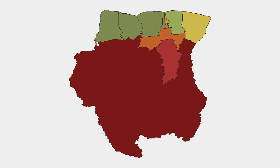
Sipaliwini District (risk score 92) and Brokopondo District (78) dominate the risk landscape, driven by illegal gold mining, weak state presence, and organized criminal supply-chain activity in the interior. Para District (74) and the capital Paramaribo (71) reflect secondary concentrations tied to urban gang activity, drug trafficking transshipment, and port-area crime. Marowijne District (68), bordering Guyana and French Guiana, remains vulnerable to cross-border smuggling and criminal movement. By contrast, western and northern coastal districts (Nickerie, Coronie, Saramacca) show substantially lower risk, reflecting greater state capacity and economic integration.
Corporate and NGO personnel should treat the interior (Sipaliwini, Brokopondo, Para) and border zones (Marowijne) as persistent elevated-risk areas regardless of current incident reporting.
How GeoBit Would Assist
Security teams with personnel or assets in Suriname should deploy Area-of-Interest (AOI) Monitoring & Early Warning focused on Sipaliwini, Brokopondo, and Marowijne to detect organized criminal activity, mining-related violence, or supply-chain disruptions before they escalate. Multi-language Intel Sweep and local news aggregator monitoring (combined with X/Telegram OSINT) will provide rapid detection of any emerging civil unrest, port incidents, or judicial-sector instability tied to ongoing SCOT proceedings. Routing & Network Analysis can identify alternative supply, personnel, and evacuation routes that avoid high-risk interior and border zones, supporting duty-of-care planning.
7-Day Outlook
Near-term conditions are expected to remain stable absent new triggering events; however, the judicial statement of July 31 warrants close watch for signs of political or institutional strain. Monitoring should continue on infrastructure resilience (particularly telecommunications in the interior) and any escalation in gold-mining-related violence or cross-border criminal activity, both of which can move rapidly but remain the primary sub-national threat drivers.
Highest-Risk Areas — Ranked
| # | State / Region | Risk |
|---|---|---|
| 1 | Sipaliwini | 92 |
| 2 | Brokopondo | 78 |
| 3 | Para | 74 |
| 4 | Paramaribo | 71 |
| 5 | Marowijne | 68 |
| 6 | Commewijne | 42 |
| 7 | Wanica | 38 |
| 8 | Saramacca | 29 |
| 9 | Coronie | 12 |
| 10 | Nickerie | 8 |
Sources
- geobit.ai
- shoeket.com
- surinamenieuwscentrale.com
- surinamenieuwscentrale.com
- surinamenieuwscentrale.com
- miragenews.com
- srnieuws.com
- surinametimes.com
- surinamesuntimes.com
- surinamenieuwscentrale.com
- surinamenieuwscentrale.com
- sun.sr
- waterkant.net
- surinamenieuwscentrale.com
- travel.state.gov
- srnieuws.com
- srnieuws.com
- surinametimes.com
Previous Daily Briefs
A new Suriname brief is written every day — each with its own risk map and downloadable CSV. Here's the last week; use the calendar to go further back.
📅 Browse every day by calendar →
Highlighted days have a brief. Tap a day for that day's map & analysis, or “csv” for that day's dataset ($5).
Atlas — our AI intelligence desk — emails them this snapshot personally. Nothing else, no list.