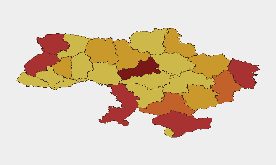
Situation Summary
Ukraine remains under sustained Russian air and missile bombardment, with overnight strikes on 11–12 July causing casualties and infrastructure damage across multiple regions. Front-line ground combat continues in parallel, maintaining active-war conditions across the country. NATO leadership warnings about potential fatigue in Western support signal risk of political instability if external security guarantees weaken. The composite threat environment—military, infrastructure, civil services, and political—places Ukraine at global rank #4 and requires continuous operational vigilance for corporate assets and personnel.
Key Developments
- Kyiv – Overnight missile and drone strikes (11–12 July). Russian forces conducted a combined air attack overnight, injuring at least 10 people and damaging residential areas and infrastructure across multiple districts. Air-raid alerts and transport disruptions remain active.
- Zaporizhzhia – Fatal missile barrage (11 July). Russian missiles and drones struck Zaporizhzhia city, killing at least 8 and wounding dozens; heightened air-raid posture and medical response activity ongoing across the region.
- Nationwide – Large-scale strike campaign (11–12 July overnight). Ukrainian and international sources report a widespread Russian missile and drone offensive across central and eastern oblasts beyond Kyiv and Zaporizhzhia, with cascading air-raid alerts and infrastructure disruptions.
- Kyiv – Utility outages amid continued strikes. Thousands of residents remain without heating; ongoing Russian attacks on energy infrastructure create vulnerability to power and water-supply interruptions, compounding civilian hardship and potential public frustration.
- NATO leadership warning on support fatigue (11 July, Brussels). Secretary-General Mark Rutte publicly urged European allies to maintain focus on Ukraine, signaling concern that geopolitical distraction could erode external security commitments and increase Ukrainian political-instability risk.
- Front-line and border activity (11–12 July). Continuing ground combat and artillery exchanges reported across multiple front-line sectors (eastern and southern axes); mines, shelling, and military checkpoints maintain high travel risk near occupied and contested areas.
Highest-Risk Areas
Kyiv (risk 100) remains the primary target for Russian strikes and the seat of political decision-making, making it both operationally and strategically critical. Cherkasy Oblast (93.9) and the southern-coastal regions—Odesa (78.5) and Autonomous Republic of Crimea (77.3)—face compounded risks from both air strikes and potential amphibious/maritime threats. Eastern oblasts (Luhansk 76.1, Donetsk 74.8, Kharkiv 72.5) remain active combat zones with ongoing ground warfare, mine contamination, and checkpoints affecting mobility. Lviv Oblast (78), despite being in the west, has been targeted in recent strike campaigns; it functions as a logistics and transit hub, making infrastructure disruption there high-impact for supply chains and evacuations.
How GeoBit Would Assist
Intel Sweep and OSINT fusion across multiple platforms (X/Telegram, YouTube, local media, radio SIGINT) provide real-time corroboration of strike reports, casualty figures, and infrastructure status—critical for confirming safety of personnel and facilities. AOI Monitoring & Early Warning with persistent watches on Kyiv, key logistics hubs (Lviv), and front-line sectors enable 24/7 alerting on new strikes, mobility restrictions, and route closures. Routing & Network Analysis supplies alternative transport corridors and safe-passage planning when primary roads are disrupted by shelling or checkpoints, and Conflict & Military battle-mapping and force-structure tracking clarify front-line positions and casualty trends to inform evacuation and continuity decisions.
7-Day Outlook
Russian strike tempo is likely to remain elevated or increase as part of a sustained air campaign; corporate teams should expect intermittent air-raid alerts, power disruptions, and transport delays nationwide, particularly in Kyiv and Zaporizhzhia. Ground combat will persist on established fronts with no immediate de-escalation signal. Western support uncertainty, if unresolved diplomatically, may drive Ukrainian government instability or shift military posture, warranting continued monitoring of official announcements and diplomatic channels.
Highest-Risk Areas — Ranked
| # | State / Region | Risk |
|---|---|---|
| 1 | Kyiv | 100 |
| 2 | Cherkasy Oblast | 93.9 |
| 3 | Odesa Oblast | 78.5 |
| 4 | Lviv Oblast | 78 |
| 5 | Autonomous Republic of Crimea | 77.3 |
| 6 | Volyn Oblast | 76.3 |
| 7 | Luhansk Oblast | 76.1 |
| 8 | Donetsk Oblast | 74.8 |
| 9 | Kherson Oblast | 73 |
| 10 | Kharkiv Oblast | 72.5 |
| 11 | Ternopil Oblast | 72.1 |
| 12 | Sumy Oblast | 71.8 |
Sources
Previous Daily Briefs
A new Ukraine brief is written every day — each with its own risk map and downloadable CSV. Here's the last week; use the calendar to go further back.
📅 Browse every day by calendar →
Highlighted days have a brief. Tap a day for that day's map & analysis, or “csv” for that day's dataset ($5).
Atlas — our AI intelligence desk — emails them this snapshot personally. Nothing else, no list.