Situation Summary
Yemen is experiencing a sharp military escalation following airstrikes on Sanaa International Airport by the Saudi-led coalition and retaliatory ballistic-missile and drone attacks by Houthi forces on Saudi Arabian infrastructure. The 2022 UN-brokered truce, which had held for several years, is now visibly fracturing under renewed airspace disputes, Iranian involvement, and direct threats to regional aviation. National risk remains elevated at composite score 98 (#12 globally), with Amanat Al Asimah (Sanaa capital region) at critical 98.5 and multiple northern governorates at 68–71, signaling nationwide exposure to renewed large-scale conflict.
Key Developments
- Sanaa International Airport, Sanaa Governorate – Monday (last 24–48h)
Saudi-led coalition aircraft struck the runway to prevent an Iranian aircraft from landing, citing Houthi obstruction of Yemeni national flights and violation of airspace rules. Direct impact on aviation infrastructure and civilian transit.
- Abha International Airport, South-Western Saudi Arabia – Monday (last 24–48h)
Houthis launched ballistic missiles and drones in response; Saudi air defenses reported interception with no initial casualties or damage. Cross-border escalation directly affecting regional civilian aviation.
- Houthi Airspace Warning – Monday (last 24–48h)
Houthi military spokesperson Yahya Saree publicly warned international airlines against flying in Saudi airspace until the Sanaa blockade is lifted, framing Saudi airspace as a conflict zone and raising overfly risk for commercial routes.
- Iranian Delegation Landing, Hodeidah Airport – Monday (last 24–48h)
An Iranian flight carrying a Houthi delegation successfully landed at Hodeidah (Hudaydah Governorate) hours after Sanaa strikes, signaling continued Iranian–Houthi coordination and operational use of alternative Houthi-controlled airports.
- UN Security Council Emergency Meeting – Monday (last 24–48h)
Members convened to address Yemen/Saudi escalations, condemning Houthi ballistic-missile launches and expressing concern over Iranian material support to the group. Diplomatic recognition of heightened instability.
- Yemen Defense Ministry Statement, Aden – Monday (last 24–48h)
The internationally recognized government stated its "patience has run out" and vowed to respond to any Iranian or Houthi airspace violations, signaling intent for further military action.
- Social Media Escalation Narrative – Last 48h
X and Facebook posts characterize the airstrikes and missile attacks as the start of "war," exaggerating but corroborating real events and accelerating perception-driven risk.
- Regime-Stability and Conflict Trajectory – Mid-July 2026
Current assessments indicate escalating military tension between state forces and Houthi-aligned actors is pushing Yemen toward renewed large-scale conflict after relative stabilization under the 2022 truce.
Highest-Risk Areas
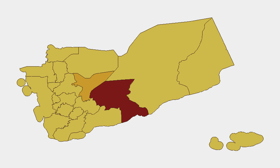
Amanat Al Asimah (Sanaa capital region, 98.5 risk) is the epicenter, hosting the contested international airport and serving as the contested seat of government. Shabwah Governorate (91.2) and Marib (71.2) remain high-risk due to ongoing militia activity and military positioning. The northern belt—Sa'dah, Al Jawf, Hajjah, and 'Amran governorates (all 68–69)—maintains elevated risk from sustained Houthi presence and cross-border military operations. These regions drive national risk because they are centers of armed-group control, Iranian supply lines, and direct military confrontation between state and non-state forces.
How GeoBit Would Assist
Security teams should deploy Intel Sweep and OSINT fusion to track real-time developments in Sanaa and Hodeidah airports, combined with X/Twitter & Telegram OSINT to monitor Houthi military statements and escalation messaging. AOI Monitoring & Early Warning on Amanat Al Asimah, Abha border zone, and key airports enables persistent alerting on airstrikes and attacks. Conflict & Military force-structure tracking and Maritime & Aviation tracking provide early indication of coalition and Houthi operational posture changes, critical for duty-of-care decisions.
7-Day Outlook
Military escalation is likely to persist through mid-to-late July, with additional airstrikes and retaliatory attacks probable if airspace disputes remain unresolved. Airlines and cross-border supply chains face elevated risk; civilian casualty potential and humanitarian disruption will increase if the truce formally collapses. Diplomatic intervention by the UN and regional actors may slow but is unlikely to halt near-term military operations.
Highest-Risk Areas — Ranked
| # | State / Region | Risk |
|---|---|---|
| 1 | Amanat Al Asimah | 98.5 |
| 2 | Shabwah Governorate | 91.2 |
| 3 | Marib Governorate | 71.2 |
| 4 | Ta'izz Governorate | 69.5 |
| 5 | Al Jawf Governorate | 69.2 |
| 6 | Sa'dah Governorate | 68.5 |
| 7 | Hajjah Governorate | 68.5 |
| 8 | Al Mahwit Governorate | 68.5 |
| 9 | Al Hudaydah Governorate | 68.5 |
| 10 | 'Amran Governorate | 68.5 |
| 11 | Sana'a Governorate | 68.5 |
| 12 | Raymah Governorate | 68.5 |
Sources
Previous Daily Briefs
A new Yemen brief is written every day — each with its own risk map and downloadable CSV. Here's the last week; use the calendar to go further back.
📅 Browse every day by calendar →
Highlighted days have a brief. Tap a day for that day's map & analysis, or “csv” for that day's dataset ($5).
Atlas — our AI intelligence desk — emails them this snapshot personally. Nothing else, no list.