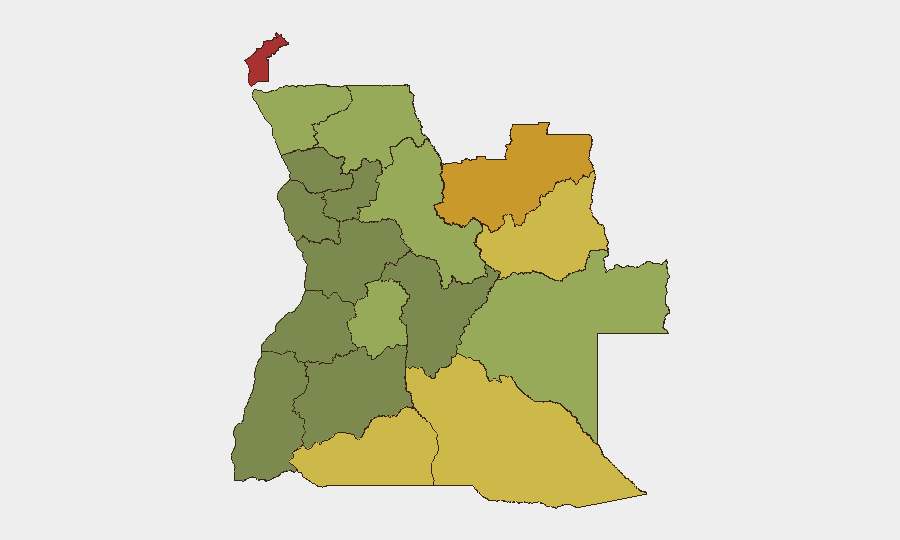
Situation Summary
Angola remains a mid-range global security concern (rank #49, composite score 37) with no tracked incidents in the current reporting period. The security environment is regionally fragmented: northeastern and eastern border provinces face persistent resource-conflict, trafficking, and militia activity, while central and southern regions show lower acute threat levels. Cholera circulation represents the most-documented recent health signal but does not constitute an active security event as of 13 July 2026.
Key Developments
No reliably documented, multi-source-confirmed security, civil-unrest, crime, or infrastructure incidents meeting location, date, and corroboration criteria were identified in Angola during the 24–48-hour window preceding this brief. Open-source and X/Twitter indexed feeds for this period contain no significant security or travel-risk developments. Teams should rely on premium alert feeds, local-language Angolan outlets, and real-time monitoring of Angola-specific social-media channels for incident capture, as open-source coverage remains sparse for near-real-time incident reporting in this geography.
Highest-Risk Areas
Cabinda Province (score 78) and the Lunda provinces (Norte: 72; Sul: 68) drive Angola's sub-national risk profile, driven by overlapping resource competition, armed-group activity, trafficking networks, and cross-border instability linked to Democratic Republic of Congo and Zambia. Cuando Cubango, Cunene, and Moxico provinces (scores 64, 62, 58 respectively) present elevated secondary risk along southern and eastern borders. Central provinces (Huambo, Uíge, Malanje) and coastal/southwestern regions (Bié, Huíla) show materially lower composite threat but remain subject to localized criminal and political activity; Luanda and other major urban centers are not ranked in the top-risk list, reflecting lower relative intensity despite absolute population exposure.
How GeoBit Would Assist
Security teams with personnel or assets in Angola should implement AOI Monitoring & Early Warning on Cabinda and the Lunda provinces to capture emerging armed-group movement, trafficking activity, and infrastructure disruption with automated alerting. Intel Sweep (global event feeds, X/Twitter & Telegram OSINT, multi-language search, and OSINT fusion) will support continuous near-real-time incident detection once local-outlet and social-media collection is configured. Routing & Network Analysis allows rapid assessment of alternative travel corridors in event of border closure or localized unrest; GIS & Spatial Analysis supports facility-risk mapping and personnel-movement planning, particularly in higher-risk eastern and northeastern zones.
7-Day Outlook
No specific acute triggers are visible on the current horizon. Activity is expected to remain consistent with baseline: low-level resource competition and trafficking in border zones, routine governance and service delivery in urban centers, and seasonal health concerns (including cholera monitoring). Security teams should maintain standard duty-of-care protocols, refresh travel authorizations for high-risk provinces, and confirm local-language monitoring of regional media to detect early signals of cross-border incursion or political volatility.
Report Date: 2026-07-13 | Global Rank: #49 | Composite Score: 37 | Tracked Events (24–48h): 0
Highest-Risk Areas — Ranked
| # | State / Region | Risk |
|---|---|---|
| 1 | Cabinda Province | 78 |
| 2 | Lunda Norte Province | 72 |
| 3 | Lunda Sul Province | 68 |
| 4 | Cuando Cubango Province | 64 |
| 5 | Cunene Province | 62 |
| 6 | Moxico Province | 58 |
| 7 | Zaire Province | 54 |
| 8 | Huambo Province | 50 |
| 9 | Uíge Province | 48 |
| 10 | Malanje Province | 42 |
| 11 | Bié Province | 35 |
| 12 | Huíla Province | 32 |
Sources
Previous Daily Briefs
A new Angola brief is written every day — each with its own risk map and downloadable CSV. Here's the last week; use the calendar to go further back.
📅 Browse every day by calendar →
Highlighted days have a brief. Tap a day for that day's map & analysis, or “csv” for that day's dataset ($5).
Atlas — our AI intelligence desk — emails them this snapshot personally. Nothing else, no list.