Situation Summary
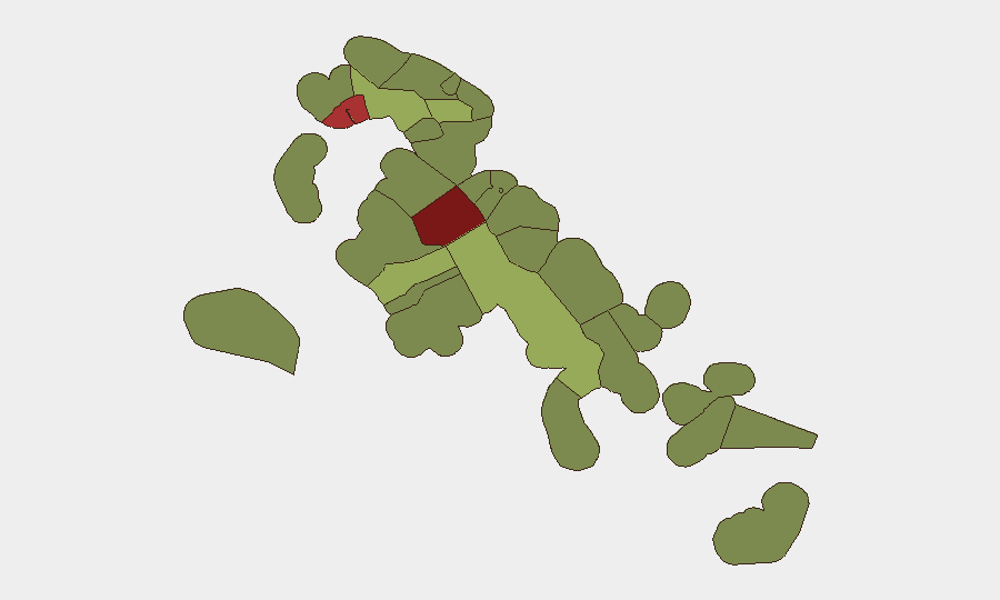
The Bahamas remains a stable mid-range jurisdiction (#77 globally) with a composite threat score of 21, but concentrates significant crime and civil-unrest risk in New Providence (Nassau) and secondary hotspots in Freeport and central Abaco. August 2026 has been marked by elevated homicide activity on West Bay Street in Nassau and a government-triggered civil unrest event in Blue Hills; however, no new verified security incidents have been reported in the past 24–48 hours. The security environment remains volatile in high-risk zones but does not indicate acute escalation.
Key Developments
No new confirmed security, crime, civil-unrest, or infrastructure incidents were verified in Bahamas during the 24–48-hour window ending 2026-08-11 05:13 UTC. The most recent tracked events are from 2026-08-04 and earlier:
- West Bay Street, Nassau (New Providence) – Two shootings reported 2026-08-03 to 2026-08-04, including one fatality on 2026-08-03 and a double shooting near noon on 2026-08-04 with one death and two hospitalizations; perpetrators and motives remain unconfirmed. These incidents reflect August's elevated homicide trend.
- Blue Hills Shantytown, Nassau (New Providence) – Government demolition of 64 structures on 2026-08-01 triggered localized civil unrest and assault on task-force personnel; potential for renewal of unrest remains unresolved.
- Blue Hills Power Station, Nassau (New Providence) – Lightning-triggered explosion on 2026-08-01 caused service loss; restoration timeline was unclear at time of reporting.
No new incidents have emerged from secondary risk zones (Freeport, Abaco, Andros, Exuma) in the current reporting window.
Highest-Risk Areas
New Providence (risk 92) drives the country-level threat profile, concentrating homicides, armed robbery, and gang activity in Nassau's urban core and shantytown districts. The City of Freeport (risk 78) ranks as the second-highest-risk jurisdiction, reflecting persistent property crime, violent crime, and gang-related activity associated with the Free Trade Zone. Central Abaco (risk 52) and Central Andros (risk 48) represent tertiary urban and settlement-based risk zones. Risk in outer islands (Cat Island, Mangrove Cay, South Abaco) remains materially lower and largely property and maritime-crime driven. Corporate and expatriate personnel should exercise heightened vigilance in Nassau (especially West Bay Street, downtown, and Blue Hills corridor) and Freeport; outer-island operations face substantially lower threat.
How GeoBit Would Assist
Security teams managing Bahamas operations would benefit from AOI Monitoring & Early Warning to track Nassau, Freeport, and secondary urban centers for new homicide, unrest, or infrastructure incidents with automated alerting; OSINT fusion (X/Twitter, local broadcast, police reports, and Telegram channels) to corroborate incident reports and motive attribution in real time; and Risk & Threat Assessment modeling to update personnel movement and asset-protection posture as threat levels fluctuate by sub-national zone. Continuous Intel Sweep against local media and security sources would provide 12–24-hour early warning of civil unrest renewal in Blue Hills or similar flashpoints.
7-Day Outlook
Near-term trajectory remains volatile but not escalating. Homicide activity in Nassau is seasonally elevated in August; the Blue Hills unrest is localized and does not signal broader civil disorder. Unless new unrest or infrastructure disruption emerges, the security picture is expected to remain within current baseline (mid-range crime, periodic violence, low political instability). Monitor West Bay Street and Blue Hills for secondary incidents; no systemic destabilization is anticipated.
Highest-Risk Areas — Ranked
| # | State / Region | Risk |
|---|---|---|
| 1 | New Providence | 92 |
| 2 | City of Freeport | 78 |
| 3 | Central Abaco | 52 |
| 4 | Central Andros | 48 |
| 5 | Exuma | 45 |
| 6 | East Grand Bahama | 42 |
| 7 | South Andros | 38 |
| 8 | North Abaco | 35 |
| 9 | North Eleuthera | 33 |
| 10 | South Abaco | 32 |
| 11 | Cat Island | 30 |
| 12 | Mangrove Cay | 28 |
Sources
Previous Daily Briefs
A new Bahamas brief is written every day — each with its own risk map and downloadable CSV. Here's the last week; use the calendar to go further back.
📅 Browse every day by calendar →
Highlighted days have a brief. Tap a day for that day's map & analysis, or “csv” for that day's dataset ($5).
Atlas — our AI intelligence desk — emails them this snapshot personally. Nothing else, no list.