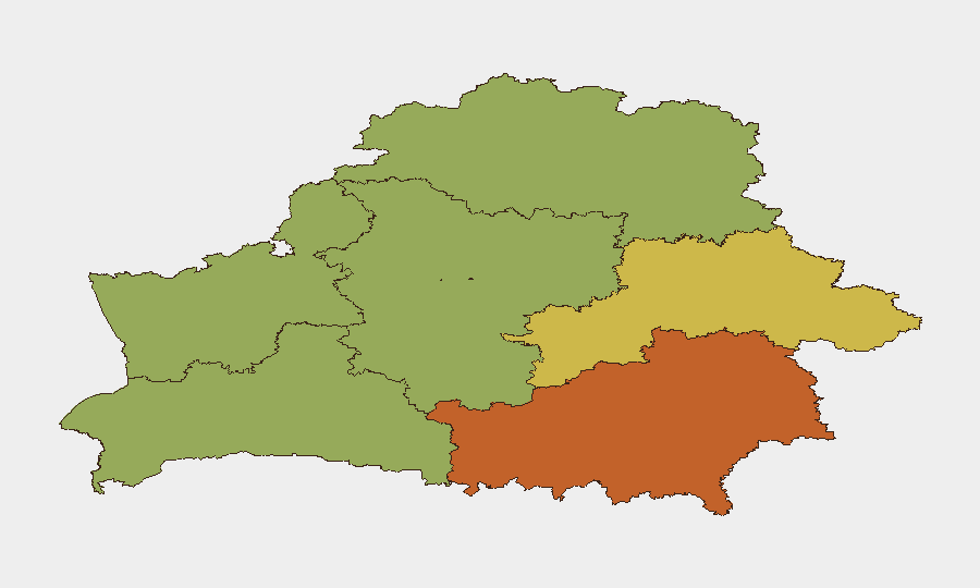
Situation Summary
Belarus remains a low-threat environment globally (rank #139, composite score 8), with no confirmed security incidents of strategic significance in the past 48 hours. Routine infrastructure maintenance, regional road accidents, and military readiness exercises dominate the current event landscape. Strategic-level activity—Lukashenko's visit to Moscow for security consultations and ongoing border-management operations—reflects normal bilateral engagement rather than crisis indicators. The security posture remains stable, though elevated police preparedness for civil unrest suggests authorities are maintaining heightened readiness.
Key Developments
- Minsk – Transport Disruption (27–28 Aug 2026). Temporary closure of central Nezalezhnosti Avenue (Yanka Kupala to Kazlova Street) for asphalting works, 20:00–19:00, causing bus/trolleybus route diversions and potential access delays to/from Minsk National Airport. No incidents reported.
- Iŭje District, Grodno Region – Fatal Road Accident (28 Aug 2026). Head-on collision between vehicles resulted in one fatality and three injuries. Underscores ongoing regional road-safety risk; no evidence of foul play.
- National – Interior Ministry Protest-Suppression Exercises (26–27 Aug 2026). Large-scale command-and-staff drills in Minsk Region simulating civil unrest, blocked routes, crowd control, vehicle arson, and hostage rescue. While simulated, these exercises indicate sustained police and security-force preparedness for potential demonstrations and signal willingness to deploy force.
- Moscow – Presidential Security Consultations (27–28 Aug 2026). Lukashenko arrived in Russia on 27 August for talks with Putin on regional and international security matters, following a surprise combat-readiness inspection of Belarusian forces. Reflects ongoing military integration and heightened operational readiness.
- Latvia–Belarus Border – Migrant Smuggling Interdiction (28 Aug 2026). Latvian security services confirmed discovery of two underground tunnels near the border used for illegal migrant crossings; related operations have interdicted routes and apprehended migrants. Indicates persistent cross-border trafficking flows but no security threat to Belarus proper.
Highest-Risk Areas
Homyel Region (risk 75) and Minsk (risk 68) remain the highest-risk sub-national zones, likely reflecting proximity to the Ukrainian conflict zone and concentration of government/security infrastructure, respectively. Mahilyow, Brest, and Hrodna regions score moderate-to-elevated risk (55–62), while Minsk Region and Vitsebsk carry lower scores (48, 45). Risk drivers appear to be transport corridors, border-management activities, and potential civil-unrest flashpoints rather than active insurgency or terrorism. No current data indicates that any region faces imminent security degradation.
How GeoBit Would Assist
Security teams with personnel or assets in Belarus should employ AOI Monitoring & Early Warning to track Minsk, Homyel, and regional transport hubs for emerging unrest, accident clusters, or infrastructure incidents with 24–48 hour lead time. OSINT fusion—combining Telegram monitoring, local media aggregation, and multi-language sentiment analysis—provides real-time visibility into protest planning and security-force posture shifts. Routing & Network Analysis helps duty-of-care teams plan alternative transport routes around temporary infrastructure works and high-accident zones, particularly Nezalezhnosti Avenue and regional highways in Grodno and Mahilyow.
7-Day Outlook
No significant threat escalation is forecast for the next seven days. Routine infrastructure maintenance and traffic management will continue in central Minsk; road-safety incidents remain a low-level baseline risk. Security-force exercises are likely to persist as part of normal preparedness cycles. Continued monitoring of Lukashenko-Putin coordination and cross-border migrant activity is warranted to detect any shifts in regional military posture or stability signaling.
Highest-Risk Areas — Ranked
| # | State / Region | Risk |
|---|---|---|
| 1 | Homyel Region | 75 |
| 2 | Minsk | 68 |
| 3 | Mahilyow Region | 62 |
| 4 | Brest Region | 55 |
| 5 | Hrodna Region | 52 |
| 6 | Minsk Region | 48 |
| 7 | Vitsebsk Region | 45 |
Sources
Previous Daily Briefs
A new Belarus brief is written every day — each with its own risk map and downloadable CSV. Here's the last week; use the calendar to go further back.
- August 26, 2026
- August 24, 2026
- August 22, 2026
- August 20, 2026
- August 18, 2026
- August 15, 2026
- August 13, 2026
📅 Browse every day by calendar →
Highlighted days have a brief. Tap a day for that day's map & analysis, or “csv” for that day's dataset ($5).
Atlas — our AI intelligence desk — emails them this snapshot personally. Nothing else, no list.