Situation Summary
Benin faces a dual-layer security picture: acute northern border instability driven by cross-border jihadist activity and weapons trafficking, and concurrent organized-crime pressure in the southern commercial hub. The country remains #null globally in GeoBit's composite ranking (score 17), reflecting fragmented but manageable threat concentrations rather than nationwide systemic instability. The past 48 hours have witnessed coordinated law-enforcement action against drug networks in the south and a major explosives interdiction in the north, suggesting both operational readiness and persistent vulnerability to smuggling corridors.
Key Developments
- Godomey, Abomey-Calavi (Atlantique Department), 28 Jul 2026: Republican Police arrested 52 suspects in a major anti-drug raid targeting trafficking and distribution networks in the Godomey district. Detainees remain under investigation to determine roles within the smuggling chain.
- Godomey, Abomey-Calavi (Atlantique Department), 28 Jul 2026: Police discovered a human skull in a tricycle and arrested two suspects in connection with the discovery. Criminal investigation is ongoing with heightened police presence in the area.
- Godomey interchange, Abomey-Calavi (Atlantique Department), 28 Jul 2026: A truck loaded with matchsticks caught fire at the Godomey interchange, causing significant traffic disruption. No official casualty figures have been reported; incident raised concerns over hazardous-material transport safety on this major commercial corridor.
- Anoum checkpoint, Sonahoulou–Djougou axis (Atacora/Donga Departments), 28–29 Jul 2026: Customs intercepted 3,295 sticks of explosives (≈500 kg) en route from Kétao (Togo) to Malanville in northern Benin. Seizure is part of an ongoing pattern of weapons and ammunition interdictions along the northern smuggling corridor.
- Northern border advisory update, 27 Jul 2026: Foreign travel advisory updated to continue strong discouragement of travel within 50 km of borders with Burkina Faso, Niger, Nigeria, and Togo, citing sustained terrorist activity and elevated kidnapping risk around Boukoumbé, Natitingou, Kérou, Kandi, and Segbana.
- Cotonou security advisory update, 27 Jul 2026: Advisory flags continued robbery and theft pressure on beaches, at Dantokpa Market (morning and evening hours), and near the port. Motorcycle-taxi robberies and injuries remain a concern; armed robberies on rural roads nationwide are occasionally reported.
Highest-Risk Areas
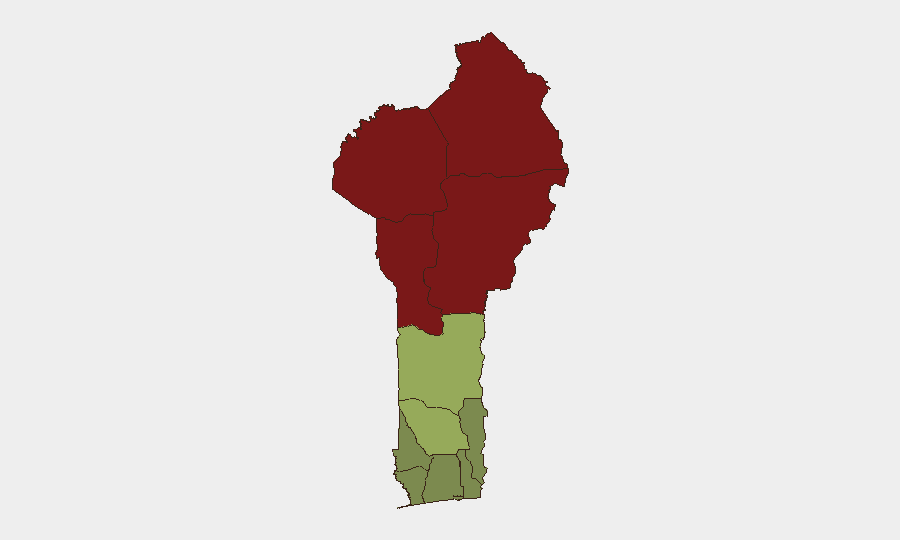
Alibori, Atakora, Donga, and Borgou departments dominate the risk ranking (scores 92, 88, 85, 83 respectively), forming a continuous high-threat band across Benin's northern frontier with Burkina Faso, Niger, and Nigeria. Jihadist activity, weapons trafficking, and kidnapping risk drive these elevations. The southern commercial zone—Atlantique, Littoral, and Ouémé departments (scores 28, 25, 22)—carries significantly lower but persistent organized-crime and urban-safety risk, concentrated in Cotonou and transport corridors like Godomey.
How GeoBit Would Assist
A security team with personnel or assets in Benin would deploy AOI Monitoring & Early Warning on the northern border departments and Godomey commercial corridor to detect emerging incident clusters before operational impact. OSINT fusion & corroboration across local media, Telegram, and regional feeds would track both jihadist-activity signals in the north and organized-crime networks in the south. Routing & Network Analysis would identify safer alternative transport pathways avoiding Godomey and northern smuggling checkpoints, while Intel Sweep and conflict-event feeds would maintain real-time situational awareness on arrests, seizures, and travel-advisory updates.
7-Day Outlook
The near-term trajectory suggests sustained but controlled law-enforcement pressure on organized-crime networks in the south, unlikely to disrupt commercial operations in Cotonou or Atlantique in the short term. Northern border risk remains elevated and stable; no immediate escalation signals, but the 500 kg explosives interdiction underscores persistent weapons-smuggling risk. Duty-of-care teams should maintain heightened vigilance on staff movements to/from northern departments and monitor Godomey-axis transport for both security and safety hazards.
Highest-Risk Areas — Ranked
| # | State / Region | Risk |
|---|---|---|
| 1 | Alibori Department | 92 |
| 2 | Atakora Department | 88 |
| 3 | Donga Department | 85 |
| 4 | Borgou Department | 83 |
| 5 | Zou Department | 45 |
| 6 | Collines Department | 42 |
| 7 | Plateau Department | 38 |
| 8 | Kouffo Department | 35 |
| 9 | Mono Department | 32 |
| 10 | Atlantique Department | 28 |
| 11 | Littoral | 25 |
| 12 | Ouémé Department | 22 |
Sources
Previous Daily Briefs
A new Benin brief is written every day — each with its own risk map and downloadable CSV. Here's the last week; use the calendar to go further back.
📅 Browse every day by calendar →
Highlighted days have a brief. Tap a day for that day's map & analysis, or “csv” for that day's dataset ($5).
Atlas — our AI intelligence desk — emails them this snapshot personally. Nothing else, no list.