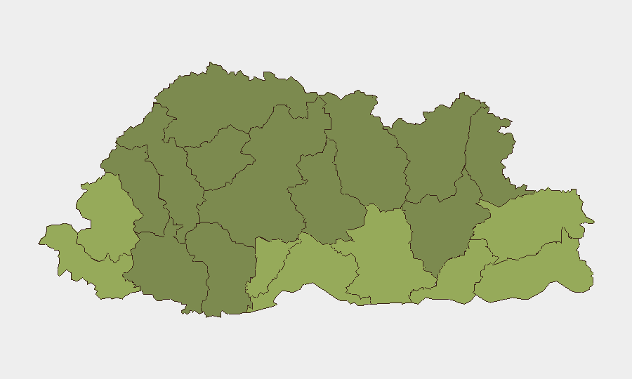
Situation Summary
Bhutan remains a low-threat environment globally (rank 176, composite score 3) with no tracked security events in the current reporting window. The country's stability reflects decades of institutionalized governance, limited civil unrest, and strong border controls. However, sub-national risk concentration in southern border districts—particularly Samtse, Sarpang, and Haa—indicates localized vulnerabilities that warrant monitoring, likely tied to cross-border dynamics, terrain challenges, and remote administration capacity.
Key Developments
No discrete security incidents were confirmed in Bhutan during the 24–48 hour window ending 8 August 2026. Bhutan Broadcasting Service (BBS) published routine crime and infrastructure updates on 8 August, but neither constituted an active threat event or significant disruption. The absence of reported incidents is consistent with Bhutan's baseline security posture.
Highest-Risk Areas
Bhutan's risk profile is heavily weighted toward its southern border districts. Samtse (risk 58), Sarpang (55), and Haa (52) rank as the three highest-risk zones, collectively accounting for a significant portion of sub-national threat concentration. These districts share geography (proximity to India, difficult terrain, sparse settlement patterns) and administrative constraints that complicate law enforcement and border management. Risk diminishes progressively northward and eastward, with central and northern districts (Wangdue Phodrang, Lhuntse, Gasa) registering substantially lower composite scores, reflecting better road access, population density, and state capacity.
How GeoBit Would Assist
Corporate security teams with personnel or assets in Bhutan should employ GeoBit's AOI Monitoring & Early Warning capability to establish persistent watches on Samtse and Sarpang districts, configured to alert on cross-border activity, informal movement, and crime signals. OSINT fusion—drawing from X/Twitter, Bhutanese media (BBS, Kuensel), NGO reports, and local government communications—provides real-time situational awareness unavailable in aggregate risk scoring. For supply chain and travel planning, Routing & Network Analysis supports identification of alternative routes and contingency logistics that avoid high-risk border zones during periods of elevated activity.
7-Day Outlook
No significant escalation is anticipated in the near term. Bhutan's political and security institutions show no signs of stress, and regional dynamics (India–China border management, monsoon logistics) are within normal seasonal parameters. Continued routine monitoring of southern districts remains prudent for duty-of-care compliance, but no alert-level changes are warranted at this time.
Data Confidence: Global threat ranking based on zero tracked events in current window. Sub-national risk scores reflect composite analysis; specific drivers of southern district elevation require live-source corroboration and are recommended for follow-up research.
Highest-Risk Areas — Ranked
| # | State / Region | Risk |
|---|---|---|
| 1 | Samtse District | 58 |
| 2 | Sarpang District | 55 |
| 3 | Haa District | 52 |
| 4 | Pemagatshel District | 50 |
| 5 | Samdrup Jongkhar District | 48 |
| 6 | Tsirang District | 45 |
| 7 | Zhemgang District | 42 |
| 8 | Trashigang District | 40 |
| 9 | Mongar District | 38 |
| 10 | Gasa District | 35 |
| 11 | Lhuntse District | 32 |
| 12 | Wangdue Phodrang District | 30 |
Sources
Previous Daily Briefs
A new Bhutan brief is written every day — each with its own risk map and downloadable CSV. Here's the last week; use the calendar to go further back.
📅 Browse every day by calendar →
Highlighted days have a brief. Tap a day for that day's map & analysis, or “csv” for that day's dataset ($5).
Atlas — our AI intelligence desk — emails them this snapshot personally. Nothing else, no list.