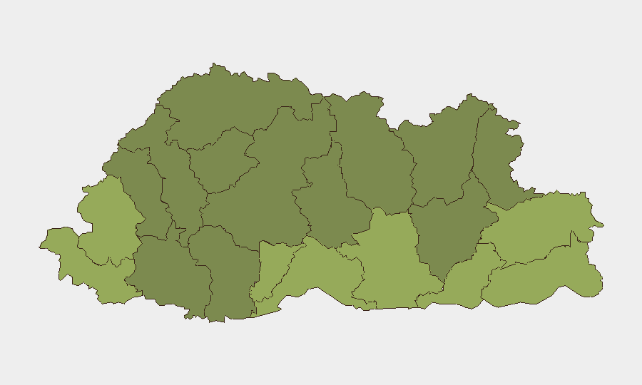
Situation Summary
Bhutan remains a stable, low-threat environment with no confirmed security incidents, civil unrest, or infrastructure disruptions reported in the past 24–48 hours. The national composite threat score stands at 3 (global rank #178), and routine operations continue across all districts, including southern border areas. Risk concentration in southern districts reflects endemic cross-border dynamics rather than active incidents or deteriorating conditions.
Key Developments
- Thimphu, 16 August 2026 – Earthquake preparedness exercise. A full-scale earthquake simulation was conducted in the capital with support from Nepalese experts and regional coordination, testing emergency response systems, hospital protocols, and equipment mobilisation. This drill reflects ongoing investment in disaster-response capability but carries no immediate security implication. [16 Aug]
- Nationwide baseline – zero tracked security incidents, 15–16 August. No confirmed reports of civil unrest, political instability, conflict, major crime, infrastructure disruption, or travel-risk events across Bhutan in the most recent 24–48-hour window. Standard low-threat operational environment maintained.
Highest-Risk Areas
Southern border districts—Samtse (risk 58), Sarpang (55), Haa (52), Pemagatshel (50), and Samdrup Jongkhar (48)—account for the top five sub-national rankings. These areas face endemic cross-border smuggling, trafficking, and irregular migration pressures stemming from porous boundaries with India and Bangladesh, compounded by limited local capacity and terrain challenges. Risk scores in these districts are significantly elevated relative to the national baseline but do not indicate active conflict, terrorism, or imminent instability. Central and northern districts (Lhuntse, Gasa, Mongar) register lower composite scores, reflecting stronger state presence and fewer transnational pressure points.
How GeoBit Would Assist
AOI Monitoring & Early Warning and Intel Sweep capabilities enable persistent watch on Samtse, Sarpang, and Haa districts for cross-border activity, trafficking networks, and irregular movement patterns—generating early alerts before such activity escalates. OSINT fusion (X, Telegram, local news, radio SIGINT) tracks emerging political or civil sentiment in real time across all districts. GIS & Spatial Analysis and Routing & Network Analysis support duty-of-care teams in planning safe travel corridors and identifying alternative routes around known pressure points; Satellite & Imagery analysis provides independent verification of border-area conditions and infrastructure status.
7-Day Outlook
Bhutan's security posture is expected to remain stable over the next seven days, with no indicators of escalating threats or sudden incidents. Southern districts will continue to experience routine cross-border pressures; the earthquake drill represents scheduled capacity-building rather than a response to acute risk. Monitoring should remain routine, with emphasis on early-warning triggers in higher-risk southern regions.
Highest-Risk Areas — Ranked
| # | State / Region | Risk |
|---|---|---|
| 1 | Samtse District | 58 |
| 2 | Sarpang District | 55 |
| 3 | Haa District | 52 |
| 4 | Pemagatshel District | 50 |
| 5 | Samdrup Jongkhar District | 48 |
| 6 | Tsirang District | 45 |
| 7 | Zhemgang District | 42 |
| 8 | Trashigang District | 40 |
| 9 | Mongar District | 38 |
| 10 | Gasa District | 35 |
| 11 | Lhuntse District | 32 |
| 12 | Wangdue Phodrang District | 30 |
Sources
Previous Daily Briefs
A new Bhutan brief is written every day — each with its own risk map and downloadable CSV. Here's the last week; use the calendar to go further back.
- August 14, 2026
- August 12, 2026
- August 10, 2026
- August 8, 2026
- August 6, 2026
- August 5, 2026
- August 4, 2026
📅 Browse every day by calendar →
Highlighted days have a brief. Tap a day for that day's map & analysis, or “csv” for that day's dataset ($5).
Atlas — our AI intelligence desk — emails them this snapshot personally. Nothing else, no list.