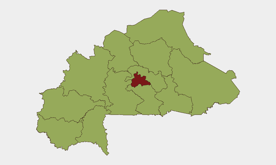
Situation Summary
Burkina Faso remains a high-threat environment (composite rank #14 globally) driven principally by active insurgency, terrorism, and kidnapping risk across multiple regions. No new kinetic attacks or significant incidents have been independently verified in the past 48 hours; however, the threat picture is sustained by persistent military operations, nationwide curfews, checkpoints, and movement restrictions that remain in force. Recent diplomatic rupture with France—including closure of French embassy services—has eliminated a key consular support channel for foreign nationals. The security posture reflects active state counterterrorism operations balanced against continued militant capability and border-area instability.
Key Developments
- Border areas (Ghana–Burkina Faso) – 19–20 July 2026: Heightened military and diplomatic tension recorded around border crossings and adjacent zones; no direct clash confirmed, but cross-border mobility and commercial logistics face increased friction and potential delays at frontier checkpoints.
- Ouagadougou and nationwide – as of mid-July, ongoing: French diplomatic mission closure (embassy and consulate) and cessation of French consular services; France maintains blanket advisory against all travel to Burkina Faso, removing evacuation and administrative support options for French and some allied nationals.
- Nationwide – 20–22 July 2026: Persistent curfews, security checkpoints, and civilian movement restrictions remain in effect across high-risk regions and operational zones; exact scope and timing vary and may shift rapidly without advance notice.
- Centre region – context: first two weeks of July, operationally relevant: State-linked reporting of security force operations killing militants and dismantling bases in multiple locations (Mangodara, Tougouri, Taparko, Kantchari, Foutouri); while pre-dating this 48-hour window, these actions explain sustained checkpoint presence and restricted movement protocols in effect today.
Highest-Risk Areas
Centre region dominates the sub-national ranking (85.3), reflecting the concentration of militant activity, IED deployment, and armed group presence in and around Ouagadougou's hinterland and central provinces. The remaining nine regions cluster at 55.3, indicating diffused but persistent threat across Upper-Basins, Boucle du Mouhoun, Sahel, and northern/eastern zones—each hosting active insurgent cells, kidnapping networks, and sporadic combat. Border regions (particularly north and east) and areas with limited state control remain highest-risk for kidnapping, banditry, and ambush. The dispersion of elevated risk across nearly the entire country reflects Burkina Faso's systemic insurgency rather than localized conflict.
How GeoBit Would Assist
Corporate security and duty-of-care teams would deploy Intel Sweep and OSINT fusion to monitor real-time event feeds, Telegram/social signals, and multi-language media for emerging incidents or checkpoint/curfew changes affecting personnel movement. AOI (Area-of-Interest) Monitoring & Early Warning with persistent watch on Centre region, border crossings, and key transport corridors would provide alerting on fresh violence, military operations, or diplomatic shifts. Routing & Network Analysis would enable security teams to model alternative travel routes, assess border-crossing viability, and plan contingency evacuations as curfew and checkpoint conditions evolve.
7-Day Outlook
No imminent escalation is signaled by current open-source data; however, the absence of reported new attacks over 48 hours does not indicate de-escalation. Curfews, checkpoints, and border tensions are likely to persist or intensify as state operations continue. Any breakdown in Ghana–Burkina Faso relations or further diplomatic isolation would increase isolation risk for foreign personnel and complicate logistics access.
Highest-Risk Areas — Ranked
| # | State / Region | Risk |
|---|---|---|
| 1 | Centre | 85.3 |
| 2 | Upper-Basins | 55.3 |
| 3 | Boucle du Mouhoun | 55.3 |
| 4 | Central-West | 55.3 |
| 5 | Central-South | 55.3 |
| 6 | Central-East | 55.3 |
| 7 | Waterfalls | 55.3 |
| 8 | Southwest | 55.3 |
| 9 | Sahel | 55.3 |
| 10 | Central-North | 55.3 |
| 11 | East | 55.3 |
| 12 | North | 55.3 |
Sources
Previous Daily Briefs
A new Burkina Faso brief is written every day — each with its own risk map and downloadable CSV. Here's the last week; use the calendar to go further back.
📅 Browse every day by calendar →
Highlighted days have a brief. Tap a day for that day's map & analysis, or “csv” for that day's dataset ($5).
Atlas — our AI intelligence desk — emails them this snapshot personally. Nothing else, no list.