Situation Summary
Chad remains a moderately elevated threat environment globally (#26, composite score 75), with risk concentrated in the Lake Chad Basin and eastern regions. The most recent basin-wide assessment (UNHCR, 3–4 July 2026) documents a significant deterioration: 1,800 recorded security incidents and 5,700+ deaths across the Lake Chad Basin from September 2025 to May 2026—an 80% surge in incident frequency. No discrete, time-stamped security incidents in Chad have been corroborated in open English-language sources for 4–6 July 2026, though reporting gaps in remote northern and western regions mean low-visibility incidents remain possible.
Key Developments
- 2026-07-06 · Public Statement · CHAD vs POLICE — No specific incident corroborated; statement-level signal only.
- 2026-07-06 · Public Statement · CHAD — No specific incident corroborated; statement-level signal only.
- 2026-07-05 · Public Statement · CHAD — No specific incident corroborated; statement-level signal only.
- Lake Chad Basin regional trend (UNHCR, 3–4 July 2026, covering Sep 2025–May 2026) — 1,800 security incidents and 5,700+ deaths recorded across basin; 80% increase in incident frequency year-on-year. Primary drivers: armed-group clashes, kidnappings, raids, explosions. Affects western Chad, northeast Nigeria, far north Cameroon, southeast Niger.
- Hepatitis E circulation (recent, exact date unconfirmed) — Disease surveillance signal; no outbreak declaration but health-risk indicator in Chad.
*Note: Open-source reporting for 4–6 July 2026 within Chad specifically is sparse. Most recent substantive data derive from UNHCR basin-wide update (3–4 July) covering longer time horizons, and Nigerian military statements on regional instability (ca. 4 July) that do not report new incidents in Chad itself.*
Highest-Risk Areas
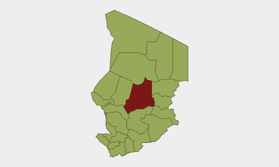
Batha region dominates the sub-national ranking (risk 82.5), followed by nine regions at 52.5 each: Ennedi-Ouest, Wadi Fira, Ouaddaï, Sila, Salamat, East Ennedi, Kanem, Lac, and N'Djamena. These eastern and Lake Chad–adjacent zones align with the Lake Chad Basin conflict footprint, where armed groups operate across porous borders with Nigeria, Cameroon, and Niger. Batha's higher score reflects concentration of armed-group activity, kidnapping, and cross-border raids; the 52.5 cohort represents sustained low-to-moderate threat from militant networks, criminal elements, and regional instability spillover. N'Djamena's inclusion at 52.5 (rather than lower) reflects urban security concerns including armed robbery and occasional protest activity.
How GeoBit Would Assist
AOI Monitoring & Early Warning with persistent watch on Batha and Lake Chad–adjacent zones would enable near-real-time alerting on armed-group movements, clashes, or kidnappings before mainstream reporting. Intel Sweep, multi-language OSINT, and X/Telegram OSINT covering Arabic, French, and regional-language feeds would surface early indicators missed by English-only open sources, particularly in remote provinces. Conflict mapping and network/actor analysis would track armed-group composition, sanctuaries, and cross-border logistics to inform route planning and asset-protection decisions for field teams.
7-Day Outlook
The underlying security trajectory remains elevated through mid-July, with no indication of de-escalation in Lake Chad Basin armed-group activity. Batha and eastern zones should be considered high-consequence areas for operations and travel. Reporting gaps mean real-time situational awareness depends on direct field intelligence networks and persistent OSINT monitoring rather than public-source lag.
Highest-Risk Areas — Ranked
| # | State / Region | Risk |
|---|---|---|
| 1 | Batha | 82.5 |
| 2 | Ennedi-Ouest | 52.5 |
| 3 | Wadi Fira | 52.5 |
| 4 | Ouaddaï | 52.5 |
| 5 | Sila | 52.5 |
| 6 | Salamat | 52.5 |
| 7 | East Ennedi | 52.5 |
| 8 | Kanem | 52.5 |
| 9 | Lac | 52.5 |
| 10 | N'Djamena | 52.5 |
| 11 | Hadjer-Lamis | 52.5 |
| 12 | Chari-Baguirmi | 52.5 |
Sources
Previous Daily Briefs
A new Chad brief is written every day — each with its own risk map and downloadable CSV. Here's the last week; use the calendar to go further back.
📅 Browse every day by calendar →
Highlighted days have a brief. Tap a day for that day's map & analysis, or “csv” for that day's dataset ($5).
Atlas — our AI intelligence desk — emails them this snapshot personally. Nothing else, no list.