Situation Summary
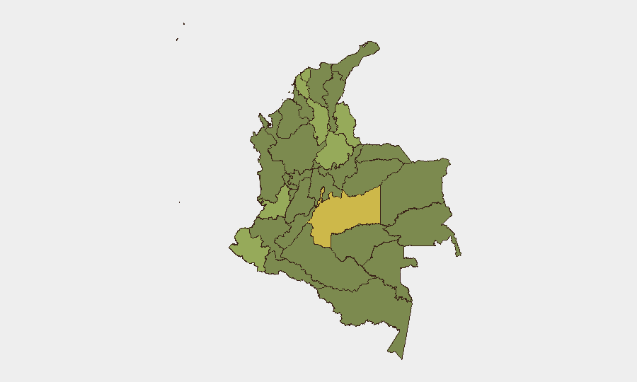
Colombia remains at composite threat level 62 globally (#35), with 332 tracked events reflecting elevated tension across government, law enforcement, and security institutions. Multiple high-profile developments over 1–2 July signal institutional strain, including an assassination of the Attorney General, military mobilization, and documented discord between executive and legislative branches. The threat landscape is geographically concentrated in frontier and coca-producing departments, with Meta, the Capital District, and Norte de Santander presenting the highest composite risk scores.
Key Developments
- 2026-07-01 · Attorney General assassination — High-impact loss of senior justice official; institutional and investigative capacity likely disrupted. Location and operational details pending clarification.
- 2026-07-01 · Military conventional force deployment — Army mobilization noted; scope and target area not yet specified in available signals.
- 2026-07-01 · Government territory occupation — Indicates state control operations, likely counter-insurgent or counter-narcotics in nature; specific location unclear.
- 2026-07-02 · Secretariat vs. Runner investigation — Intelligence/investigative action; suggests internal or inter-agency friction or pursuit of a targeted actor.
- 2026-07-02 · High-level arrest/detention (Colombia–US nexus) — Bilateral law-enforcement action; possible extradition-related or narcotics-trafficking case.
- 2026-07-02 · Congressional disapproval of President — Legislative challenge to executive authority; signals institutional discord on policy or security response.
- 2026-07-01 · Prosecutor public statement — Justice sector voice; likely response to Attorney General incident or institutional crisis management.
Highest-Risk Areas
Meta Department (64.2) and the Capital District (61.0) dominate the risk landscape, followed by the tri-border Norte de Santander (53.3) and southern Nariño (50.6). Meta's elevated score reflects coca cultivation, irregular armed group activity, and competition for territorial control in the Llanos region. The Capital District concentration reflects both political tension (evidenced by recent congressional–executive friction) and organized crime networks. Norte de Santander and Nariño remain conduits for drug trafficking and harbor active ELN and dissident FARC presence. Mid-tier risk in Santander, Atlántico, and Valle del Cauca suggests secondary conflict nodes and urban crime pressure.
How GeoBit Would Assist
Corporate security teams would deploy Intel Sweep and multi-language event feeds to track real-time developments in institutional stability and armed-group activity, cross-referenced with network and actor analysis to map which officials, agencies, or criminal organizations are driving current instability. Area-of-interest monitoring with alerting on Meta, Norte de Santander, and Nariño would provide early warning of territorial shifts, displacement, or trafficking route disruptions affecting supply chains or personnel safety. Conflict and military mapping, paired with satellite and imagery analysis, would enable security teams to assess army deployments and occupation operations in coca zones and monitor risk to regional assets.
7-Day Outlook
The assassination of the Attorney General and concurrent military mobilization suggest a potential crisis response or security operation targeting a high-value actor or group; expect continued institutional friction and possible further arrests or detentions. The next 48–72 hours will likely see clarity on the scope of military operations and whether U.S.–Colombia coordination signals a major counter-narcotics or counter-insurgency action. Personnel and asset security in Meta, Capital District, and Norte de Santander should remain elevated pending stabilization of institutional messaging and confirmation of operational objectives.
Highest-Risk Areas — Ranked
| # | State / Region | Risk |
|---|---|---|
| 1 | Meta Department | 64.2 |
| 2 | Capital District | 61 |
| 3 | Norte de Santander Department | 53.3 |
| 4 | Nariño | 50.6 |
| 5 | Santander Department | 44.2 |
| 6 | Atlántico Department | 43.6 |
| 7 | Valle del Cauca Department | 42 |
| 8 | Bolívar Department | 41.5 |
| 9 | Cundinamarca Department | 39.8 |
| 10 | Antioquia Department | 37.7 |
| 11 | Amazonas | 36.6 |
| 12 | Caquetá Department | 36.3 |
Previous Daily Briefs
A new Colombia brief is written every day — each with its own risk map and downloadable CSV. Here's the last week; use the calendar to go further back.
📅 Browse every day by calendar →
Highlighted days have a brief. Tap a day for that day's map & analysis, or “csv” for that day's dataset ($5).