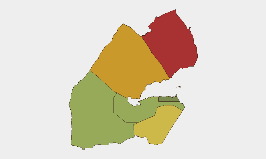
Situation Summary
Djibouti remains a stable, low-threat operating environment (global rank #86, composite score 18) with no tracked security events of national significance in the current reporting cycle. Recent incidents—a U.S. military aircraft accident, a naval engagement with a suspected smuggling vessel, and isolated violent crime—represent localized events rather than systemic instability. The northern and eastern regions (Obock, Tadjourah, Ali Sabieh) carry elevated risk profiles, driven by maritime trafficking, remote terrain, and proximity to Yemen; the capital and surrounding areas remain relatively secure for routine business and diplomatic operations.
Key Developments
- Chabelley Airfield, Djibouti City area (9–10 Aug 2026): U.S. Embassy confirmed a U.S. MQ-9A Reaper drone crashed shortly after takeoff near Chabelley Airfield; no casualties or property damage reported. Investigation ongoing; cause not yet disclosed.
- Djibouti territorial waters (8 Aug 2026): Djiboutian naval forces engaged a suspected Yemeni smuggling vessel; exchange of fire resulted in two Djiboutian soldiers wounded. Vessel intercepted and incident attributed to routine maritime enforcement operations.
- Hodan area, Djibouti City (11 Aug 2026): Police arrested a male suspect in connection with stabbing his girlfriend multiple times near a bakery; victim transported with abdominal and back wounds. Suspect detained at Gabode prison; classified as interpersonal violence, not organized crime or terrorism.
- Djibouti City (11 Aug 2026): Police arrested a suspect accused of using AI-generated tools to produce fraudulent WAAFI mobile payment confirmations. Emerging financial-crime concern; limited location detail available.
Highest-Risk Areas
Obock (score 78) and Tadjourah (score 72) in the north dominate the sub-national risk profile, reflecting their proximity to Yemen, remote geography, and historical use as transit corridors for maritime smuggling and irregular migration. Ali Sabieh (score 65) in the southwest adds cross-border trafficking and porous frontier dynamics to the risk picture. By contrast, Djibouti City and immediate surroundings (score 35) remain the safest zone, hosting diplomatic, military, and commercial infrastructure with robust security presence. Risk in northern and eastern regions should inform supply-chain routing, personnel movement, and asset-protection posture for organizations with operations across the country.
How GeoBit Would Assist
Teams operating in Djibouti should employ AOI Monitoring & Early Warning to track the northern Red Sea and Gulf of Aden approaches for maritime threat emergence; OSINT fusion and X/Twitter & Telegram intelligence to detect emerging crime networks and financial-fraud schemes (as flagged by the recent AI-payment case); and Routing & Network Analysis to identify secure alternate routes for personnel and supply movements, especially in Obock and Tadjourah. Satellite and maritime tracking capabilities would provide real-time visibility into port activity and vessel movements relevant to smuggling interdiction.
7-Day Outlook
No imminent escalation is expected; the recent incidents appear isolated and localized. Continued low-level maritime interdiction operations along the Yemen border should be anticipated as routine. Security teams should maintain standard duty-of-care protocols in Djibouti City and exercise heightened situational awareness for personnel transiting the north; the drone accident investigation may yield procedural or airspace-management updates worth monitoring.
Highest-Risk Areas — Ranked
| # | State / Region | Risk |
|---|---|---|
| 1 | Obock | 78 |
| 2 | Tadjourah | 72 |
| 3 | Ali Sabieh | 65 |
| 4 | Arta | 48 |
| 5 | Dikhil | 42 |
| 6 | Djibouti | 35 |
Sources
Previous Daily Briefs
A new Djibouti brief is written every day — each with its own risk map and downloadable CSV. Here's the last week; use the calendar to go further back.
📅 Browse every day by calendar →
Highlighted days have a brief. Tap a day for that day's map & analysis, or “csv” for that day's dataset ($5).
Atlas — our AI intelligence desk — emails them this snapshot personally. Nothing else, no list.