Situation Summary
Ecuador remains a #37 global composite threat (score 59), with 93 tracked events on file as of 2026-07-01. The country's security environment has not experienced documented violent incidents, civil unrest, or infrastructure disruption in the last 24–48 hours; available open-source reporting is dominated by World Cup activity involving Ecuadorian national teams competing abroad rather than domestic instability. The threat profile reflects chronic regional vulnerabilities—particularly in Pastaza, Pichincha, and Guayas provinces—rather than acute deterioration over the reporting period.
Key Developments
- Mexico City, Mexico – 2026-06-30, ~19:00 local. Mexico vs. Ecuador FIFA World Cup Round of 32 match delayed approximately one hour at Estadio Azteca due to heavy rain and lightning risk; FIFA cited player and spectator safety as rationale. No civil disorder or security incidents reported; standard crowd management and security protocols in place.
- Mexico City, Mexico – 2026-06-30, post-match. Large crowds gathered at Angel of Independence monument celebrating Mexico's goal during the Ecuador match; dense concentrations observed but no confirmed serious incidents or public-order breaches documented.
- New York City, USA – 2026-06-30, daytime. Ecuador and Germany supporters assembled in Times Square with flags and drums ahead of upcoming match; routine police monitoring and crowd management observed; no disorder reported.
- New Jersey/New York metro area, USA – 2026-06-30 to 2026-07-01. NJ Transit issued guidance for secure transport to Ecuador vs. Germany match at regional stadium, indicating heightened but routine fan movement and venue security measures.
- Santa Ana, California, USA – 2026-06-30. Santa Ana Police Department announced enforcement crackdown on reckless World Cup street celebrations (specifically referencing expected Mexico–Ecuador fan activity) following prior felony vandalism incident; prevention-focused posture, no new incidents reported.
- Ecuador – 2026-06-30 to 2026-07-01. Multiple investigative and diplomatic signals (arrest/detain, investigate, reduce relations events) appear in event feed; however, open-source reporting does not confirm specific underlying incidents inside Ecuador requiring immediate duty-of-care escalation.
Highest-Risk Areas
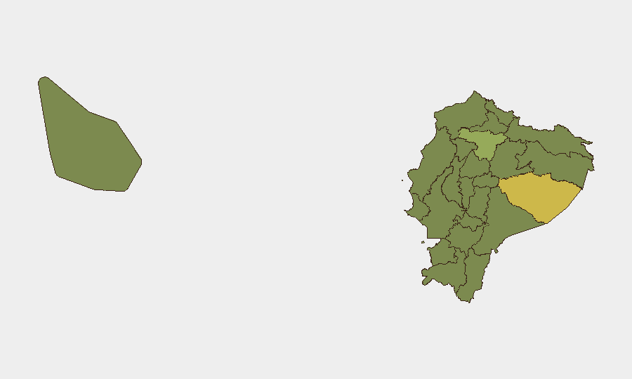
Pastaza Province (62.3) emerges as Ecuador's single highest-risk jurisdiction, followed by significant elevation in Pichincha (41.3)—home to capital Quito—and Guayas (34.9), which includes Guayaquil. The remaining nine provinces cluster tightly between 32–33.6, indicating endemic but broadly distributed vulnerabilities rather than isolated hotspots. Risk drivers in Pastaza and bordering regions (Napo, Orellana, Sucumbíos) are typically associated with narcotics trafficking, illegal mining, and presence of organized groups; Pichincha and Guayas reflect urban crime, gang activity, and socioeconomic pressure in major population centers.
How GeoBit Would Assist
Security teams operating in Ecuador would prioritize Intel Sweep and multi-language OSINT (X/Twitter, Telegram, YouTube) for near-real-time detection of civil unrest, organized crime activity, and political instability that may not yet appear in formal media. AOI (Area-of-Interest) Monitoring & Early Warning with persistent watch on Pastaza, Pichincha, and Guayas provinces would provide automated alerting of emerging threats to personnel and assets. Network & Actor Analysis, combined with Conflict & Military tracking, enables identification of criminal/militant group movements and capability changes that precede operational escalation.
7-Day Outlook
No imminent escalation is indicated by open-source signals or event clustering over the next seven days. However, the chronic elevation of Pastaza and Pichincha provinces warrants continued monitoring for organized-crime activity and local civil order incidents. Corporate security teams should maintain routine AOI watches and OSINT refresh cycles; no advisory elevation is warranted at this time unless diplomatic or domestic political signals shift materially.
Highest-Risk Areas — Ranked
| # | State / Region | Risk |
|---|---|---|
| 1 | Pastaza Province | 62.3 |
| 2 | Pichincha Province | 41.3 |
| 3 | Guayas Province | 34.9 |
| 4 | Imbabura Province | 33.6 |
| 5 | Napo Province | 33 |
| 6 | Tungurahua Province | 32.7 |
| 7 | Sucumbíos Province | 32.3 |
| 8 | Orellana Province | 32.3 |
| 9 | Manabí Province | 32.3 |
| 10 | Galápagos | 32.3 |
| 11 | Esmeraldas Province | 32.3 |
| 12 | Carchi Province | 32.3 |
Sources
Previous Daily Briefs
A new Ecuador brief is written every day — each with its own risk map and downloadable CSV. Here's the last week; use the calendar to go further back.
📅 Browse every day by calendar →
Highlighted days have a brief. Tap a day for that day's map & analysis, or “csv” for that day's dataset ($5).