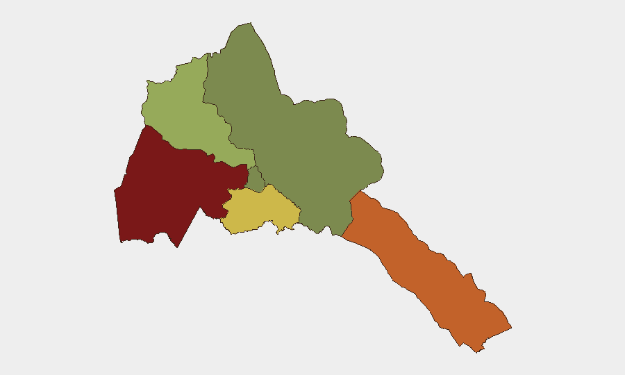
Situation Summary
Eritrea itself remains internally stable with no verified security incidents or unrest reported within its borders in the past 48 hours. However, the country's military posture and alleged operational involvement in renewed clashes across the Ethiopia–Tigray border substantially elevate regional risk. Recent fighting in Western Tigray and multiple reports of Eritrean command-level presence and coordination suggest active military engagement despite official denials, creating volatility that could rapidly affect travel corridors, supply chains, and personnel safety in border regions and diaspora communities.
Key Developments
- Western Tigray / Shererina area clashes – Aug 2–3, 2026: Tigray's interim administration reported renewed Ethiopian federal offensive at dawn Saturday; Al Jazeera confirmed heavy artillery and drone strikes, with hundreds of Tigrayans fleeing into Sudan by Sunday afternoon. Fighting subsided by Sunday, but extent of casualties and tactical objectives remain unclear.
- Eritrean military commanders reported entering Tigray – Aug 2, 2026: Social media reporting indicates Eritrean regime military commanders were present in Ethiopia's Tigray region on this date, suggesting active operational coordination; major newswires have not independently verified, but aligns with documented Eritrean anti-TPLF activity.
- Heavy weapons repositioning reported on Ethiopia–Eritrea axis – Aug 2–4, 2026: Conflict monitors cited movement of heavy weapons toward southern Tigray border, with analysts warning of escalating militarization; claims remain largely video- and social-media sourced pending independent confirmation.
- Ethiopia's ambassador to Kenya explicitly names Eritrea as command hub – Aug 2–4, 2026: Diplomatic statement asserts any renewed TPLF offensive would be "led from Asmara," attributing Eritrea a central coordinating role; Eritrea's information ministry responded with denials and counter-accusations of media fabrication.
- Australia updates travel advisory – early August 2026: Smartraveller raised caution levels for Eritrea overall, citing risk of potential conflict with neighboring countries rather than internal incidents.
Highest-Risk Areas
Gash-Barka (risk 92) and Southern Red Sea Region (risk 75) are significantly more exposed than other Eritrean territory, driven by proximity to the Ethiopia–Tigray conflict theater and historical patterns of cross-border military activity. Debub Region (risk 68) faces elevated risk from the same dynamic. By contrast, Maekel Region (risk 18), which includes the capital Asmara, remains relatively insulated from immediate fighting but remains subject to broader political volatility and military mobilization. Northern Red Sea Region shows minimal tracked risk at present.
How GeoBit Would Assist
Corporate security teams should employ AOI Monitoring & Early Warning on border crossings and military positions in Gash-Barka and Southern Red Sea Region to detect escalation signals before they affect operations. Conflict & Military tracking—including force structure and weapons-capability assessment—combined with OSINT fusion (social media, YouTube conflict monitors, and multi-language open reporting) will enable real-time corroboration of unverified claims of Eritrean military presence and coordination. Routing & Network Analysis can model alternative supply and personnel evacuation corridors if border volatility intensifies.
7-Day Outlook
Short-term risk of major escalation inside Eritrea remains low, but the pattern of reported military buildup and Eritrean command involvement in neighboring Tigray conflict suggests sustained elevated regional tension. If Ethiopian–TPLF clashes resume at scale, spillover effects—including military mobilization, supply-chain disruption, and diplomatic escalation—are probable within 7–14 days. Personnel and asset security teams should maintain heightened monitoring of border regions and prepare contingency plans for rapid personnel repositioning.
Highest-Risk Areas — Ranked
| # | State / Region | Risk |
|---|---|---|
| 1 | Gash-Barka | 92 |
| 2 | Southern Red Sea Region | 75 |
| 3 | Debub Region | 68 |
| 4 | Anseba | 55 |
| 5 | Maekel Region | 18 |
| 6 | Northen Red Sea Region | 0 |
Sources
Previous Daily Briefs
A new Eritrea brief is written every day — each with its own risk map and downloadable CSV. Here's the last week; use the calendar to go further back.
📅 Browse every day by calendar →
Highlighted days have a brief. Tap a day for that day's map & analysis, or “csv” for that day's dataset ($5).
Atlas — our AI intelligence desk — emails them this snapshot personally. Nothing else, no list.