Situation Summary
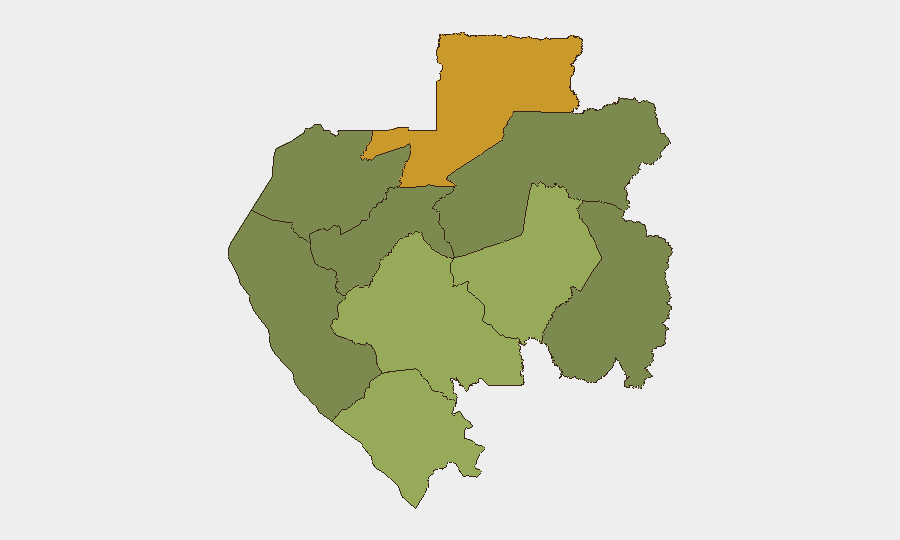
Gabon remains a low-threat environment globally (#144 composite rank) with no confirmed security incidents in the last 24–48 hours. The underlying political climate remains tense due to the three-month detention of opposition leader Alain Claude Bilie By Nze in Libreville, which human-rights groups have characterized as arbitrary; however, this has not generated measurable civil unrest or travel-disruption events in recent days. The northern forest province of Woleu-Ntem carries significantly elevated sub-national risk (score 72) driven by cross-border factors and remote-area governance gaps, but no acute incident-level activity has been reported there in the last two days.
Key Developments
- No incident-level events meeting 24–48-hour criteria were identified in open-source reporting or social-media streams as of 29 July 2026. OpenWatch and mainstream outlets show 25 monitored events over the past seven days but flag no actionable discrete incidents, clashes, protests, or infrastructure failures with precise recent timestamps.
- Political detention and opposition pressure remain ambient-level concerns in Libreville. Opposition leader Alain Claude Bilie By Nze remains in solitary confinement since 15 April; international media and civil-society monitoring continue to highlight this as a governance-legitimacy risk for the interim CTRI authorities, but no new protests or related security events have been clearly dated to the last 48 hours.
- Wildfire activity in neighbouring Congo carries potential transboundary air-quality and evacuation-route implications. A tracked regional wildfire (Event 1029642, Congo–Gabon border zone) is flagged in the event feed; no direct Gabon territory impact has been reported, but seasonal fire risk in the equatorial region warrants monitoring for transport or health-service disruption.
- No changes to consular posture, curfews, or travel alerts reported in the last 48 hours. French diplomatic presence remains present; no new advisories have been issued by major capitals regarding Libreville or internal transport corridors.
Highest-Risk Areas
Woleu-Ntem Province (risk 72) dominates the sub-national threat landscape, reflecting its remote northeastern position, limited state capacity, and proximity to Equatorial Guinea and Cameroon borders—zones where smuggling, wildlife trafficking, and cross-border militia activity create structural vulnerability. Ogooué-Lolo (58) and Ngounié (48) provinces follow, driven by similar factors: weak road infrastructure, dispersed population, and limited security-force presence. By contrast, Estuaire Province (15), home to Libreville and the capital's formal administrative and commercial hubs, carries substantially lower risk despite ambient political tension. Risk concentration in the forest interior suggests that corporate operations in remote mining, timber, or hydrocarbon zones face greater exposure to lawlessness and accident hazard than urban or coastal operations.
How GeoBit Would Assist
Teams managing operations in Gabon's higher-risk provinces would benefit from AOI Monitoring & Early Warning on Woleu-Ntem and Ogooué-Lolo, coupled with Intel Sweep and multi-language OSINT to detect emerging cross-border smuggling networks or militia activity before they affect access roads. Satellite & Imagery analysis and Environmental & Health monitoring are useful for wildfire, flooding, and disease-outbreak early warning in remote zones. Routing & Network Analysis supports secure journey planning for personnel traveling to mining or exploration sites where formal infrastructure is sparse.
7-Day Outlook
No significant escalation in political unrest or security incidents is anticipated over the next seven days absent a major development in the opposition leader's legal status or a new regime action perceived as severe. Seasonal weather patterns (wet season) may increase accident risk on interior roads and worsen air quality near the Congo border. Routine monitoring of Libreville political channels and cross-border networks should continue as baseline practice.
Highest-Risk Areas — Ranked
| # | State / Region | Risk |
|---|---|---|
| 1 | Woleu-Ntem | 72 |
| 2 | Ogooué-Lolo Province | 58 |
| 3 | Ngounié Province | 48 |
| 4 | Nyanga Province | 42 |
| 5 | Haut-Ogooué Province | 35 |
| 6 | Moyen-Ogooué Province | 28 |
| 7 | Ogooué-Maritime Province | 25 |
| 8 | Estuaire Province | 15 |
| 9 | Ogooué-Ivindo | 0 |
Sources
Previous Daily Briefs
A new Gabon brief is written every day — each with its own risk map and downloadable CSV. Here's the last week; use the calendar to go further back.
📅 Browse every day by calendar →
Highlighted days have a brief. Tap a day for that day's map & analysis, or “csv” for that day's dataset ($5).
Atlas — our AI intelligence desk — emails them this snapshot personally. Nothing else, no list.