Situation Summary
Haiti remains under extreme security pressure, ranking #31 globally with gang violence as the primary driver. Port-au-Prince is experiencing a sustained surge in kidnappings targeting high-level officials and civilians, armed ambush-style attacks on main urban routes, and continued gang territorial control despite ongoing multinational and Haitian police suppression operations. The security picture is deteriorating in the short term, with authorities implementing maximum-alert measures and new checkpoints even as some strategic roads are being cleared.
Key Developments
- Port-au-Prince, Delmas–city center (Friday, July 31): Ecclésiaste Thélémaque, Chief of Staff to the Minister of National Education, was kidnapped while returning home. This marks an escalation in targeting high-level government officials, significantly raising kidnap risk for government, NGO, and diplomatic personnel in the capital.
- Port-au-Prince, Delmas 33 near Peace Hospital (Saturday, August 1): Businessman Clifford Handal and his father were attacked by heavily armed individuals in a sustained-gunfire ambush. An armored vehicle escort enabled their escape, confirming active armed kidnap-attempt capability on main urban routes.
- Port-au-Prince metropolitan area (Saturday, August 1): Haitian National Police High Command announced new security measures in response to gang territorial control and recent high-profile kidnappings. New checkpoints and operations are expected, raising short-term movement risk across the capital.
- Port-au-Prince, strategic roads and central districts (July 31–August 1): The UN-backed Gang Suppression Force and specialized police units continued operations, with some major roads partially reopened. High volatility persists near cleared roads and contested neighborhoods due to ongoing clashes.
- Port-au-Prince and surrounding communes (last 48 hours, as of August 1): Authorities report maximum-alert status, with more than 5,500 violent deaths within the past year and gangs expanding territorial control. Recent attacks, kidnappings, and police operations underscore an extreme baseline security environment.
- Tabarre sector, eastern Port-au-Prince (updated through end of July): The Force de Réponse Groupée (FRG) continues targeted security operations following a June 21 raid. Sporadic clashes are likely near gang positions and police staging areas, affecting movement in the sector.
- National level (Saturday, August 1): Prime Minister Alix Didier Fils-Aimé reiterated commitment to improving security and institutional conditions for upcoming elections. Continued political instability signals risk of protests, counter-actions by armed groups, and violence around official buildings.
Highest-Risk Areas
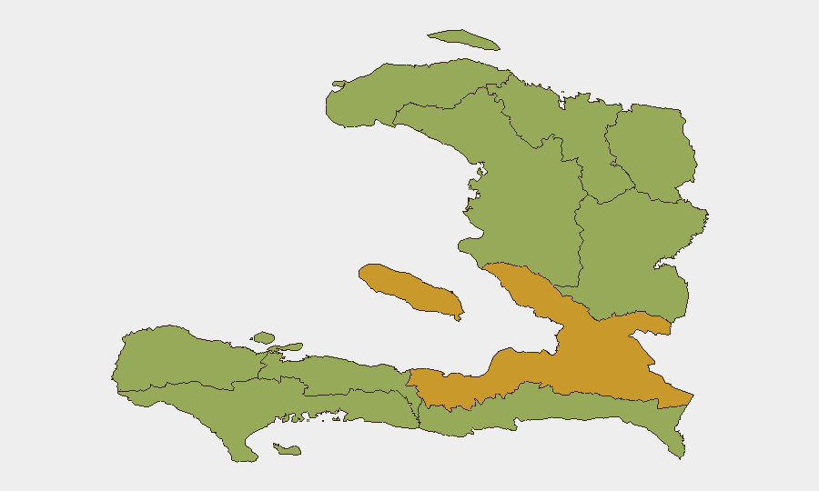
*de l'Ouest* Department (risk score 72.9) dominates the national threat profile, driven primarily by gang territorial control and kidnapping activity in Port-au-Prince and surrounding urban centers. *Centre* Department (54.3) follows significantly, while *Sud*, *Artibonite*, *Grande-Anse*, *Nippes*, and remaining northern and eastern departments cluster between 42.9–44.3. The sharp differential reflects Port-au-Prince's role as the epicenter of gang violence and a magnet for kidnapping, extortion, and armed assault targeting civilians and officials.
How GeoBit Would Assist
Security teams should deploy AOI Monitoring & Early Warning (persistent watch on Port-au-Prince districts, Delmas corridor, and key institutional buildings) paired with Intel Sweep and multi-language OSINT (X, Telegram, local radio SIGINT) to detect kidnap planning, gang movement, and police operations in real time. Routing & Network Analysis enables identification of secure movement corridors and checkpoints, while Conflict & Military mapping tracks Gang Suppression Force and police positions to avoid active clash zones.
7-Day Outlook
Gang kidnappings of high-value targets are likely to continue or intensify as criminal organizations test state security capacity and secure ransom leverage. Increased police checkpoints and multinational operations will create short-term movement friction and volatility across Port-au-Prince. Election-related political activity and statements will probably trigger secondary protest or gang-motivated violence, sustaining maximum-alert conditions through early August.
Highest-Risk Areas — Ranked
| # | State / Region | Risk |
|---|---|---|
| 1 | de l'Ouest Department | 72.9 |
| 2 | Centre Department | 54.3 |
| 3 | Sud Department | 44.3 |
| 4 | Artibonite Department | 44.3 |
| 5 | Grande-Anse Department | 42.9 |
| 6 | Nippes Department | 42.9 |
| 7 | Nord-Ouest Department | 42.9 |
| 8 | Nord Department | 42.9 |
| 9 | Nord-Est Department | 42.9 |
| 10 | Sud-Est Department | 42.9 |
Sources
Previous Daily Briefs
A new Haiti brief is written every day — each with its own risk map and downloadable CSV. Here's the last week; use the calendar to go further back.
📅 Browse every day by calendar →
Highlighted days have a brief. Tap a day for that day's map & analysis, or “csv” for that day's dataset ($5).
Atlas — our AI intelligence desk — emails them this snapshot personally. Nothing else, no list.