Situation Summary
Iran remains at elevated composite threat level (#4 globally, score 100) amid active ceasefire negotiations with the United States and ongoing regional security assertions. The immediate security environment is characterized by de-escalatory maritime movements in the Strait of Hormuz—where Iran has eased wartime shipping restrictions—alongside continued political rhetoric positioning Iran's military posture as non-negotiable. No major civil unrest, terror attacks, or infrastructure sabotage incidents were documented inside Iran in the last 24–48 hours; current instability is concentrated in diplomatic and military-capability signaling rather than domestic crises.
Key Developments
- Strait of Hormuz (June 23–24): Iran has partially eased wartime restrictions on maritime traffic, now allowing a limited, coordinated daily vessel flow. This shift reduces immediate interdiction risk for commercial shipping but preserves Iran's operational control over passage conditions and the ability to rapidly re-tighten restrictions.
- Tehran (June 24): President Pezeshkian stated during a Pakistan visit that Iran will not accept limits on its missile capabilities as part of current peace accords and rejected international inspector access to damaged nuclear sites—signaling continued military assertion and nuclear opacity in negotiations.
- Abu Dhabi / Gulf Region (June 24): U.S. Secretary of State Marco Rubio traveled to reassure Gulf partners that Iran's missile and drone programs remain unconstrained under the initial ceasefire framework, reflecting regional concern over Iran's strike capabilities developed during the conflict.
- Gulf Capitals (June 24–25): Iran's government framed the initial war-ending agreement as a "declaration of US defeat," while simultaneously floating proposals to charge environmental/security fees for Hormuz passage—indicating continued contest over maritime security arrangements and control.
- Regional Military Balance (ongoing through June 24): U.S. analysis notes Iran's earlier missile and drone campaigns degraded at least 20 U.S. military sites across the region; these degraded U.S. air-defense systems remain a live factor in current deterrence calculations.
Highest-Risk Areas
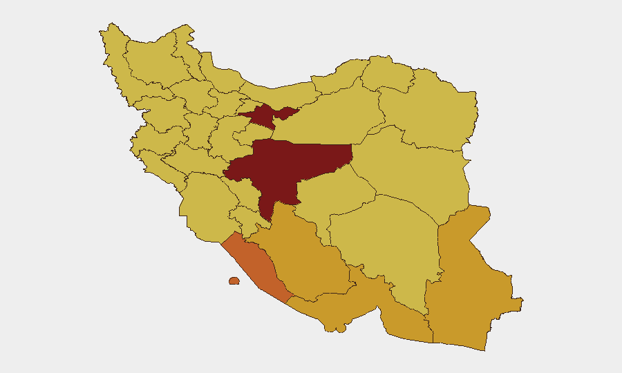
Tehran Province (risk 100) and Isfahan Province (risk 94) dominate the sub-national ranking and likely reflect concentration of government institutions, security-force activity, and political decision-making in the capital and major administrative centers. The southern maritime provinces—Bushehr (73), Hormozgan (71.3), and Fars (71.9)—rank high due to naval infrastructure, Strait of Hormuz proximity, and exposure to U.S. military presence during the recent conflict. Sistan and Baluchestan (71.4) and border provinces (West Azerbaijan, East Azerbaijan, South Khorasan) carry sustained elevation tied to separatist and sectarian tensions documented since February 2026.
How GeoBit Would Assist
Security teams monitoring Iran would employ Intel Sweep and multi-language OSINT feeds to track government statements, military positioning, and maritime traffic signals in near-real-time. AOI Monitoring & Early Warning on Tehran, Isfahan, and Hormozgan provinces—combined with Maritime tracking of Strait of Hormuz vessel movements and Network & Actor Analysis of Iranian military and security-force communications—would enable persistent detection of escalation or unrest before major incidents crystallize. Conflict & Military force-structure and capability tracking would complement open-source assessment of Iran's current operational posture.
7-Day Outlook
Ceasefire momentum is expected to hold in the near term, with further easing of Hormuz restrictions likely as negotiations advance. However, political rhetoric around Iran's nuclear program, missile capabilities, and maritime control suggests continued friction in final accord terms, creating volatility risk around June 25–30 if talks stall. Domestic security risk remains subdued; primary concern is rapid escalation in maritime or air operations should diplomatic negotiations collapse.
Highest-Risk Areas — Ranked
| # | State / Region | Risk |
|---|---|---|
| 1 | Tehran Province | 100 |
| 2 | Isfahan Province | 94 |
| 3 | Bushehr Province | 73 |
| 4 | Fars Province | 71.9 |
| 5 | Sistan and Baluchestan Province | 71.4 |
| 6 | Hormozgan Province | 71.3 |
| 7 | East Azerbaijan Province | 70.8 |
| 8 | Chaharmahal and Bakhtiyari Province | 70.6 |
| 9 | West Azerbaijan Province | 70.6 |
| 10 | South Khorasan Province | 70.6 |
| 11 | Razavi Khorasan | 70.1 |
| 12 | Khuzestan Province | 70.1 |
Sources
Previous Daily Briefs
A new Iran brief is written every day — each with its own risk map and downloadable CSV. Here's the last week; use the calendar to go further back.
📅 Browse every day by calendar →
Highlighted days have a brief. Tap a day for that day's map & analysis, or “csv” for that day's dataset ($5).