Situation Summary
Israel remains at threat level #3 globally (composite score 100) driven by active armed conflict, with 432 tracked events in the current reporting cycle. Recent event signals indicate escalating multi-domain tension: unconventional violence by Hamas, Israeli aerial weapons use, property seizure in Palestinian areas, and coordinated international diplomatic pressure (UK sanctions, Turkish disapproval, UN rejection). The trajectory points toward sustained high-intensity operations with compounding diplomatic isolation.
Key Developments
Web Research Limitation: GeoBit's live web research (last 24–48 hours, June 30–July 2, 2026) could not surface reliably time-stamped, independently corroborated incidents specific to that window. Available sources lack clear publication dates or are archived/closed liveblog material without verifiable incident timing. The following signals are drawn from GeoBit's event-feed analysis and require on-ground validation:
- South District / Gaza Strip (June 30–July 1) – Unconventional violence reported by Hamas; concurrent Israeli property seizure and threat escalation against Palestinian areas indicates ground-level tactical friction and potential for civilian displacement.
- Aerial operations region-wide (June 30) – Israeli aerial weapons deployment tracked across multiple districts; no specific target location confirmed in available reporting, but signals suggest sustained air campaign operations.
- Cross-border (June 29–July 1) – Turkish public statements and disapproval on June 29–30, followed by UK administrative sanctions on July 1, indicate diplomatic pressure intensifying parallel to kinetic activity; potential for further international condemnation or restrictions on Israeli entities.
- International escalation (June 30–July 1) – Israeli threats toward Palestinian entities and rejection of UN positions signal hardened posture; combined with military official statements on July 1, suggests command consensus on continued operations without international constraint.
Note: Specific locations, precise incident counts, and casualty figures for the 24–48 hour window could not be independently verified. Corporate security teams should supplement this brief with direct feeds from IDF statements, Magen David Adom (MDA) emergency alerts, and Israeli media wires (YNet, Haaretz, KAN) for real-time incident confirmation.
Highest-Risk Areas
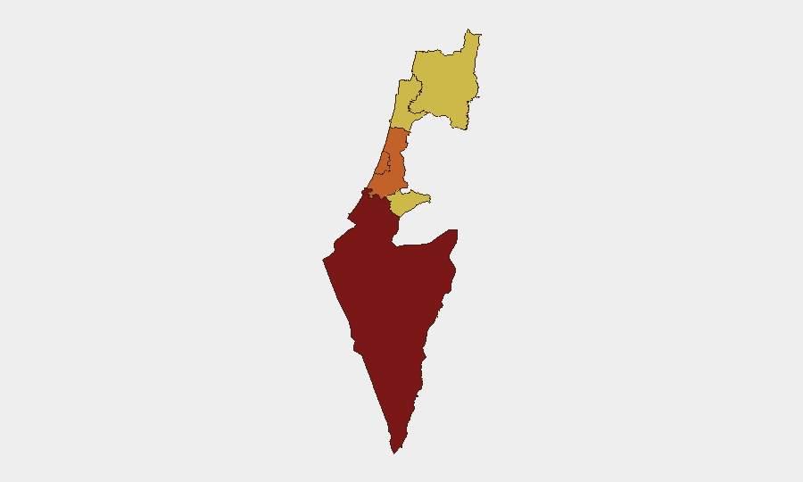
South District (risk 100) dominates the threat landscape and is the primary driver of Israel's #3 global ranking—active conflict zone with dense population and ongoing unconventional-violence operations. Tel Aviv, Center, and Jerusalem Districts (risk 73–74 range) face secondary but significant exposure through airspace vulnerability, transportation choke points, and symbolic targeting risk. Haifa and North Districts (risk 70) reflect cross-border spillover from Lebanon and Syria, where Israeli security-zone operations and Hezbollah presence create persistent strike and retaliation potential. Risk concentration in the South reflects both ground-force intensity and civilian population density; secondary districts face primarily air and indirect-fire threats.
How GeoBit Would Assist
Security teams should activate AOI Monitoring & Early Warning on South District, Tel Aviv, and Jerusalem—persistent watch with alerting on movement, gatherings, and incident signatures. Multi-language OSINT fusion (X, Telegram, YouTube, local Israeli media) combined with temporal and entity extraction provides real-time incident corroboration and actor identification. Battle mapping and force-structure tracking enable duty-of-care teams to plot safe corridors and monitor Israeli/Palestinian/militant unit positions for dynamic route planning.
7-Day Outlook
Sustained kinetic operations in the South are expected to continue; international diplomatic pressure (sanctions, public statements) will likely increase without military de-escalation. Risk of spillover into secondary districts through air operations or retaliation remains elevated. Corporate assets and personnel in South, Tel Aviv, and Center Districts should assume persistent threat posture and maintain 24–48 hour contingency-evacuation readiness.
Highest-Risk Areas — Ranked
| # | State / Region | Risk |
|---|---|---|
| 1 | South District | 100 |
| 2 | Tel-Aviv District | 73.8 |
| 3 | Center District | 73.7 |
| 4 | Jerusalem District | 70.3 |
| 5 | Haifa District | 70 |
| 6 | North District | 70 |
Sources
Previous Daily Briefs
A new Israel brief is written every day — each with its own risk map and downloadable CSV. Here's the last week; use the calendar to go further back.
📅 Browse every day by calendar →
Highlighted days have a brief. Tap a day for that day's map & analysis, or “csv” for that day's dataset ($5).