Situation Summary
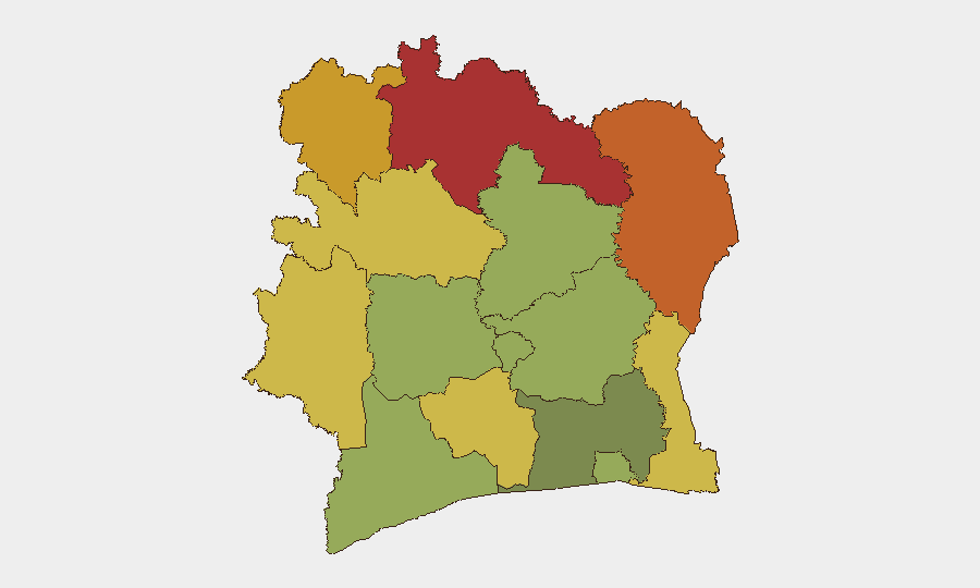
Ivory Coast remains ranked #54 globally with a composite threat score of 21, reflecting a fragmented but manageable security environment. The northern border districts—Savanes, Zanzan, Denguélé, and Comoé—drive the majority of measured risk, driven by persistent cross-border activity and limited state capacity in remote areas. Abidjan and southern coastal zones remain substantially more stable, though recent severe weather has created secondary humanitarian and infrastructure disruption. Overall trajectory is stable pending seasonal and political developments.
Key Developments
- Abidjan (Attécoubé and Yopougon districts) – 23–24 July 2026
Torrential rainfall resulted in severe urban flooding, with at least 10 confirmed fatalities reported in Attécoubé and Yopougon, including a family of nine. Submerged roads, including Carrefour 09 Kilos, have disrupted local mobility and pose immediate transit hazard to personnel and supply chains.
- Abidjan (citywide) – 23–24 July 2026
Infrastructure damage from flooding has caused localized road closures and transit delays across multiple communes. Travel via secondary and tertiary routes is advised until drainage and road-safety assessments are completed.
- National – 23 July 2026
The Conseil National de Sécurité released a statement affirming that ongoing defense and security operations have maintained national-level stability. The assessment suggests no acute political or civil unrest at the center, though it is a strategic political statement rather than an operational incident report.
- Governance activity – 24 July 2026
A demonstration or rally related to governance issues was recorded in GEOBIT event feeds. Specific location, turnout, and outcome remain limited in open reporting; monitoring of Abidjan and regional administrative centers recommended.
Note on coverage limitations:
GEOBIT's 24–48-hour event horizon for Ivory Coast is currently constrained by limited real-time cross-border and remote-region reporting. Northern districts (Savanes, Zanzan) see infrequent discrete incident disclosure; corroboration of activities in those zones typically requires 3–7-day lag or official government announcements. The flooding event in Abidjan is the only discrete, location-specific incident confirmed within the brief window.
Highest-Risk Areas
The four northern districts—Savanes (78), Zanzan (75), Denguélé (72), and Comoé (70)—account for the majority of Ivory Coast's measured composite risk, reflecting sparse state presence, cross-border smuggling corridors, and periodic militant activity originating in Mali and Burkina Faso. Montagnes (68) and Woroba (65) districts extend this belt of elevated risk westward. In contrast, Abidjan (45) and the southern coastal belt remain substantially lower-risk environments, with threats concentrated on weather/infrastructure resilience and occasional civil-order incidents rather than organized armed activity. Any significant deterioration in the northern border region would require immediate escalation; southern operations remain routine-hazard focused.
How GeoBit Would Assist
A corporate security team operating in Ivory Coast should deploy AOI Monitoring & Early Warning on Savanes, Zanzan, and Comoé districts to detect cross-border movement and resource-extraction disruption in near-real time. Multi-language OSINT (X/Twitter, local media, Telegram) with sentiment and temporal analysis would capture governance unrest, flooding impacts, and road-closure alerts faster than official channels. Routing & Network Analysis and satellite/imagery review would enable dynamic rerouting of personnel and supply chains around Abidjan flooding and northern access constraints.
7-Day Outlook
The northern border threat level is expected to remain elevated and episodic; seasonal rains will exacerbate Abidjan and southern infrastructure fragility through August. Governance demonstrations are likely to recur around administrative decisions or economic grievances; no imminent political crisis is signaled by current official statements. Personnel should anticipate persistent mobility challenges in Abidjan and route-planning delays in the north; northern travel should remain restricted to essential, vetted movements.
Highest-Risk Areas — Ranked
| # | State / Region | Risk |
|---|---|---|
| 1 | Savanes District | 78 |
| 2 | Zanzan District | 75 |
| 3 | Denguélé District | 72 |
| 4 | Comoé District | 70 |
| 5 | Montagnes District | 68 |
| 6 | Woroba District | 65 |
| 7 | Gôh-Djiboua District | 60 |
| 8 | Sassandra-Marahoué District | 58 |
| 9 | Vallée du Bandama District | 55 |
| 10 | Bas-Sassandra District | 52 |
| 11 | Lacs District | 48 |
| 12 | Abidjan | 45 |
Previous Daily Briefs
A new Ivory Coast brief is written every day — each with its own risk map and downloadable CSV. Here's the last week; use the calendar to go further back.
📅 Browse every day by calendar →
Highlighted days have a brief. Tap a day for that day's map & analysis, or “csv” for that day's dataset ($5).
Atlas — our AI intelligence desk — emails them this snapshot personally. Nothing else, no list.