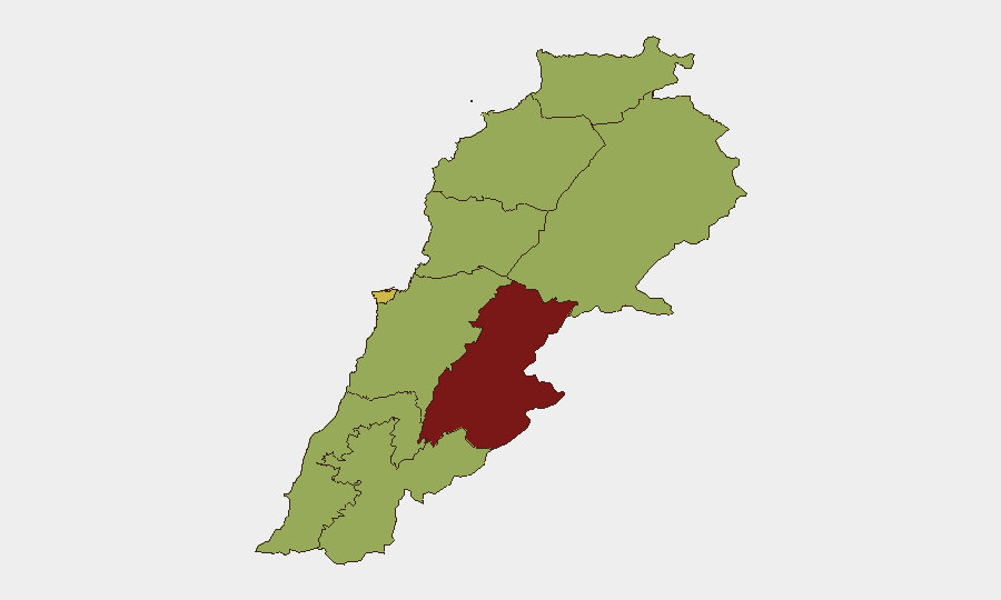
Situation Summary
Lebanon remains in active conflict, with Israeli military operations ongoing in southern regions despite a nominal ceasefire framework agreed in late June 2026. Hezbollah infrastructure and border localities continue to experience airstrikes and artillery fire, compounded by sporadic ground exchanges along the Israeli security zone. Beirut and other urban centers face intermittent disruptions from protests, security cordons, and air-alert related road closures, creating unpredictable access constraints for civilians and international personnel. The overall trajectory is volatile, with de-escalation fragile and re-escalation risk elevated.
Key Developments
- Maroun al-Ras and southern border ridgelines (29 June): Israeli artillery and drone strikes hit areas around Maroun al-Ras in Bint Jbeil District, with secondary fires reported; Hezbollah-linked accounts posted impact footage consistent with targeting Hezbollah positions near the Israeli border fence.
- Nabatieh area (29 June): Multiple reports of Israeli airstrikes on suspected Hezbollah infrastructure north of Nabatieh; residents and conflict monitors documented overhead jets and explosions across the South Governorate.
- East of Tyre/Sour (29 June): Israeli drone surveillance and at least one precision strike reported on agricultural plots and structures east of Tyre; local authorities implemented temporary road closures.
- Border exchanges, South Governorate (ongoing, 29 June): Continuing fire and overflights documented along multiple segments of the southern border, including areas opposite Metula and Kiryat Shmona, indicating sustained Israeli ground and aerial operations within the self-declared security zone.
- Rafic Hariri International Airport access routes (29 June): Intermittent road closures and heavy congestion on key approach roads reported, attributed to security checks and air-alert disruptions; Canadian travel advisory confirms sporadic airport-access degradation due to air strikes.
- Beirut district protests (evening 29 June): Small political gatherings and road-blocking demonstrations documented over the ceasefire framework and government performance; protests creating localized travel delays and security checkpoints in central areas.
- Beqaa Valley security activity (29 June): Heightened security checkpoints and sporadic celebratory gunfire reported; NGOs advising staff to limit non-essential evening movement, consistent with Beqaa's elevated risk profile.
- Countrywide travel guidance (29 June): Multiple embassies and governments reiterated "avoid all travel" advisories citing latest Israeli strikes and escalation risk; Canadian government updated overall Lebanon risk to avoid all travel due to volatile conditions.
Highest-Risk Areas
Beqaa Governorate (84.7 composite risk) is the single highest-risk region, driven by armed activity, sporadic gunfire, and security-checkpoint density. Beirut (65.3) faces secondary risk from protest activity, air-alert disruptions, and airport-access volatility, creating duty-of-care exposure for staff movement and evacuation planning. The southern governorates—Nabatieh, South, and others clustered at 54.7–54.9—experience direct Israeli military pressure, with airstrikes, drone surveillance, and ground exchanges creating sustained kinetic risk for anyone in or transiting these areas. North and Akkar governorates face tertiary but non-negligible risk from spillover activity and security checks.
How GeoBit Would Assist
Security teams should deploy AOI Monitoring & Early Warning on Beqaa Valley and southern border localities to receive automated alerts on new strike patterns and security checkpoint activity, reducing reactive response lag. Conflict & Military battle mapping and satellite imagery analysis enable near-real-time assessment of Hezbollah infrastructure targeting and Israeli force positioning, critical for evacuation route planning. Routing & Network Analysis capability supports dynamic alternative-route and journey planning around documented closures and air-alert zones, protecting personnel movement to and from Beirut airport and other choke points.
7-Day Outlook
Israeli operations in the south are likely to continue at current or elevated tempo, with ceasefire compliance deteriorating. Beirut protests and government instability may increase, creating secondary but recurring road-closure and access-delay risk. Re-escalation potential remains high; any significant cross-border incident or Hezbollah retaliation could trigger rapid shift to full-scale conflict and mass-casualty events.
Highest-Risk Areas — Ranked
| # | State / Region | Risk |
|---|---|---|
| 1 | Beqaa Governorate | 84.7 |
| 2 | Beirut Governorate | 65.3 |
| 3 | Nabatieh Governorate | 54.9 |
| 4 | North Governorate | 54.7 |
| 5 | Akkar Governorate | 54.7 |
| 6 | Keserwan-Jbeil Governorate | 54.7 |
| 7 | Mount Lebanon Governorate | 54.7 |
| 8 | South Governorate | 54.7 |
| 9 | Baalbek-Hermel Governorate | 54.7 |
Sources
Previous Daily Briefs
A new Lebanon brief is written every day — each with its own risk map and downloadable CSV. Here's the last week; use the calendar to go further back.
📅 Browse every day by calendar →
Highlighted days have a brief. Tap a day for that day's map & analysis, or “csv” for that day's dataset ($5).