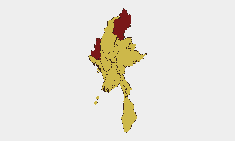
Situation Summary
Myanmar remains in active conflict across multiple fronts, with the military government engaged in conventional operations against armed ethnic organizations (notably Kachin Independence Organization forces in the north) and facing domestic rejection and physical assaults on 23 June. The security environment is characterized by persistent sub-national armed-group activity, civil unrest, and military counter-operations, with no major de-escalation indicators. Flooding concurrent with active conflict has compounded humanitarian and access challenges. Overall threat trajectory remains elevated with no near-term resolution pathway evident.
Key Developments
- 23 June, multiple locations: Conventional military force engagements reported involving Kachin forces versus Myanmar military; specific tactical details and casualty counts not independently corroborated in current open-source reporting.
- 23 June, nationwide: Multiple physical assault incidents and rejection actions recorded; limited geographic specificity available in verified reporting.
- 23 June: Military government and Development Council forces reported to have engaged in physical assaults; exact locations and context under verification.
- Recent (date not time-stamped): Flooding event reported across Myanmar (ID 1103937); humanitarian impact and infrastructure damage assessment ongoing.
Data caveat: GeoBit Intelligence notes a current 24–48 hour verification gap in independently corroborated, time-stamped incident reports from open sources. While conflict activity is assessed as ongoing, specific recent incidents cannot be robustly validated from available English-language open-source intelligence at this time. Security teams should cross-reference local media, NGO field reports, and community networks for ground-truth confirmation.
Highest-Risk Areas
Kachin State (risk score 100) remains the primary theater, reflecting sustained conventional military operations between government and ethnic armed organizations with no de-escalation. Chin State (86.3) and Shan State (70.7) follow as secondary conflict zones with active insurgent presence and military operations. Yangon (70.4), the commercial capital, presents elevated risk driven by urban protest activity, rejection incidents, and police-civilian friction; this directly affects corporate operations, supply chains, and expatriate presence. Ten additional regions cluster at risk score 70, indicating conflict is geographically dispersed rather than concentrated, multiplying area-denial and access challenges across the country.
How GeoBit Would Assist
Intel Sweep and multi-language OSINT (X/Twitter, Telegram, local media feeds) enable 24-hour monitoring of conflict developments and civil unrest in real time, filling current reporting gaps as incidents are posted and cross-referenced. AOI (Area-of-Interest) Monitoring with alerting on Kachin State, Yangon, and Shan State enables duty-of-care teams to receive automated notifications when activity spikes in zones where personnel or assets operate. Battle mapping and force-structure tracking clarify military and armed-group dispositions and recent maneuver, supporting route planning and movement decisions. GIS and satellite imagery analysis assess infrastructure damage (roads, ports, power, fuel supply) and humanitarian impact (flooding), informing supply-chain resilience and staff welfare decisions.
7-Day Outlook
No major escalation or ceasefire signals are evident. Conventional military operations in Kachin and Shan are likely to continue at present intensity; urban unrest in Yangon may fluctuate with political or security-force actions. Flooding impact may temporarily disrupt logistics and humanitarian access, further constraining movement. Risk remains elevated and unchanged through early July absent major political or military shift.
Highest-Risk Areas — Ranked
| # | State / Region | Risk |
|---|---|---|
| 1 | Kachin State | 100 |
| 2 | Chin | 86.3 |
| 3 | Shan State | 70.7 |
| 4 | Yangon | 70.4 |
| 5 | Tanintharyi Region | 70 |
| 6 | Sagaing Region | 70 |
| 7 | Wa State (Northern Region) | 70 |
| 8 | Magway | 70 |
| 9 | Mandalay | 70 |
| 10 | Rakhine | 70 |
| 11 | Ayeyarwady | 70 |
| 12 | Naypyitaw Union Territory | 70 |
Sources
Previous Daily Briefs
A new Myanmar brief is written every day — each with its own risk map and downloadable CSV. Here's the last week; use the calendar to go further back.
📅 Browse every day by calendar →
Highlighted days have a brief. Tap a day for that day's map & analysis, or “csv” for that day's dataset ($5).