Situation Summary
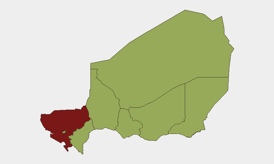
Niger remains classified as a moderate-to-high global security risk (rank #18, composite score 82) amid ongoing governance tensions, cross-border pressures, and localized instability. Recent signals suggest elevated diplomatic friction between Niger and Nigeria, coupled with domestic investigative and administrative actions. The security environment remains fragmented by region, with Tillabéri Region presenting substantially elevated risk compared to the remainder of the country.
Key Developments
- 2026-06-29, nationwide: Nigerian authorities launched an investigation into an unspecified matter; timing and scope remain unclear from available signals.
- 2026-06-29, nationwide: A disapproval statement issued by Niger's government or a major domestic actor; context requires verification.
- 2026-06-28, nationwide: Domestic disapproval signal recorded; specific grievance or actor not yet clarified.
- 2026-06-27, Niamey area (inferred): Niger's government issued a public statement in response to or directed at Nigeria, suggesting bilateral diplomatic activity.
- 2026-06-27, unspecified location: A demand was made by Nigeria toward Niger's ministry or ministerial officials.
- 2026-06-27, unspecified location: Property seizure or damage incident involving Nigerian nationals and Niger police; scale and casualties not yet confirmed.
- 2026-06-27, regional: African Union or regional body issued disapproval signal related to Nigeria, potentially implicating Niger's bilateral posture.
- 2026-06-27, unspecified location: Media sanctions were imposed on Niger by or related to Nigeria, suggesting information control or press restrictions.
Note: Event signals indicate diplomatic and administrative friction; specific casualty counts, tactical details, and verified locations remain incomplete pending corroboration.
Highest-Risk Areas
Tillabéri Region (risk score 87) stands as Niger's clear security outlier, more than 30 points above all other tracked regions and driving the country's overall threat profile. Agadez, Zinder, Diffa, Niamey, Tahoua, Dosso, and Maradi regions cluster at risk score 57, indicating more uniform but still-elevated baseline insecurity. The concentration of critical infrastructure, humanitarian activity, and cross-border exposure in Tillabéri (bordering Mali and Burkina Faso) likely explains its disproportionate risk ranking; operations and personnel deployment in that region warrant heightened security protocols and contingency planning.
How GeoBit Would Assist
Security teams operating in Niger should employ Intel Sweep and global event feeds to monitor Niamey's diplomatic signaling and bilateral dynamics with Nigeria in real time. AOI Monitoring & Early Warning with persistent watch on Tillabéri Region, combined with multi-language OSINT (French, Arabic, local languages) and X/Twitter & Telegram OSINT, enables early detection of localized flare-ups, criminal activity, or protest escalation before they impact corporate assets or personnel. GIS & Spatial Analysis and alternative route/journey planning tools allow duty-of-care teams to identify secure transit corridors and contingency evacuation routes, particularly for operations in or transiting through high-risk zones.
7-Day Outlook
Diplomatic tension between Niger and Nigeria is likely to remain elevated over the next week, with potential for further public statements or administrative actions. Tillabéri Region should be monitored closely for any security incident spillover from the broader Sahel instability; absence of major incident reporting does not indicate reduced underlying threat. Corporate operations should maintain heightened situational awareness and ensure communication and evacuation protocols are current.
Highest-Risk Areas — Ranked
| # | State / Region | Risk |
|---|---|---|
| 1 | Tillabéri Region | 87 |
| 2 | Agadez Region | 57 |
| 3 | Zinder Region | 57 |
| 4 | Diffa Region | 57 |
| 5 | Niamey | 57 |
| 6 | Tahoua Region | 57 |
| 7 | Dosso Region | 57 |
| 8 | Maradi Region | 57 |
Sources
Previous Daily Briefs
A new Niger brief is written every day — each with its own risk map and downloadable CSV. Here's the last week; use the calendar to go further back.
📅 Browse every day by calendar →
Highlighted days have a brief. Tap a day for that day's map & analysis, or “csv” for that day's dataset ($5).