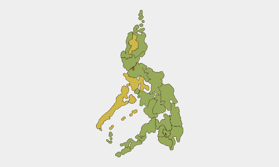
Situation Summary
The Philippines remains a moderate global security concern (rank #36, composite score 62) with 144 tracked threat events, characterized by a mixture of armed crime, political unrest, and targeted violence concentrated in specific high-risk zones. Metro Manila dominates the sub-national ranking (73.1) and continues to host both large-scale political demonstrations and organized crime activity, while the Mindanao corridor—particularly Maguindanao del Sur—faces renewed armed group and clan-related violence. The security environment shows no immediate systemic destabilization but reflects persistent criminality and localized conflict that demands sustained monitoring and tactical awareness.
Key Developments
- Shariff Aguak, Maguindanao del Sur – 18 July, 06:30 hrs
Grenade attack on an Army transport along the Cotabato City–Isulan Highway injured 2 soldiers and 3 civilians; suspects on a motorcycle fled toward Mamasapano, prompting joint military–police pursuit operations and heightened security checkpoints across the corridor.
- Cotabato City – 17–19 July (overnight and weekend)
Three separate shooting incidents killed 4 people and injured 6, including an off-duty police officer struck by stray fire; police attribute incidents to clan feuds (rido) and have reinforced patrols and checkpoints throughout the city.
- Marikina City, Metro Manila – reported 19 July
Eight suspects impersonating police, NBI, and SWAT personnel conducted an armed home invasion and robbery of a businessman; multiple criminal charges filed, investigation ongoing with additional suspects at large.
- Liwasang Bonifacio, Manila – 19 July
Thousands gathered for a United People's Initiative "People's Indignation Rally" on political issues; event was peaceful but created significant foot-traffic and crowd-management considerations in central Manila.
- Echague, Isabela (Barangay Malibago) – 17 July
Barangay councilor shot dead inside his resort; incident under investigation and indicative of targeted political or communal violence in provincial areas.
- Lubao, Pampanga – 17 July
Barangay captain arrested within 12 hours of allegedly shooting a truck driver during a traffic dispute; case reflects armed violence tied to road altercations and rapid law-enforcement response.
Highest-Risk Areas
Metro Manila's rank-1 position (73.1) reflects overlapping organized crime, armed robbery, and mass-gathering risks in a high-density urban environment; the capital remains a magnet for both criminal activity and political mobilization. Mindanao's western and central zones—Cordillera, Mimaropa, and Soccsksargen (66, 66, and 55.3 respectively)—are driven by armed group presence, clan violence, and periodic military operations, with the Shariff Aguak grenade attack and Cotabato City shooting spree illustrating active tactical threats along key transportation routes. Bicol, Davao, and Northern Mindanao regions (47–46 range) remain moderately elevated due to residual criminal networks and localized insurgent activity.
How GeoBit Would Assist
Security and duty-of-care teams should employ AOI Monitoring & Early Warning on Metro Manila, Cotabato City, and Shariff Aguak corridors to detect emerging violence signals in real-time; Routing & Network Analysis to identify safe transit alternatives avoiding checkpoint congestion and conflict zones; and OSINT Fusion & Corroboration (X/Telegram, local news, radio SIGINT) to track rido clan activity, police operations, and armed group movements before they escalate. Conflict & Military capability enables tracking of Western Mindanao Command operations and force positioning.
7-Day Outlook
The Mindanao armed-violence cluster is likely to sustain elevated security operations and checkpoint presence along the Cotabato–Isulan corridor for 7–10 days while military and police pursue the grenade-attack perpetrators. Metro Manila will continue hosting periodic mass gatherings; crime (robbery, impersonation) will remain endemic. No imminent shift to wider instability is signaled, but targeted violence and clan feuds will remain recurring tactical risks in provincial and Mindanao zones.
Highest-Risk Areas — Ranked
| # | State / Region | Risk |
|---|---|---|
| 1 | Metro Manila | 73.1 |
| 2 | Cordillera Administrative Region | 66 |
| 3 | Mimaropa | 66 |
| 4 | Soccsksargen | 55.3 |
| 5 | Bicol Region | 47.4 |
| 6 | Davao Region | 45.8 |
| 7 | Northern Mindanao | 44.7 |
| 8 | Negros Island Region | 44.7 |
| 9 | Zamboanga Peninsula | 44.7 |
| 10 | Cagayan Valley | 44.2 |
| 11 | Western Visayas | 44.2 |
| 12 | Bangsamoro | 43.1 |
Sources
Previous Daily Briefs
A new Philippines brief is written every day — each with its own risk map and downloadable CSV. Here's the last week; use the calendar to go further back.
📅 Browse every day by calendar →
Highlighted days have a brief. Tap a day for that day's map & analysis, or “csv” for that day's dataset ($5).
Atlas — our AI intelligence desk — emails them this snapshot personally. Nothing else, no list.