Situation Summary
Somalia remains in active civil conflict, with al-Shabaab conducting sustained operations against Somali government and AUSSOM forces across central and southern regions. The past 48 hours have seen intensified militant assault activity, particularly in the strategically contested Afgooye–Mogadishu corridor, coupled with government-led counter-operations targeting al-Shabaab infrastructure and senior operatives. The threat environment is characterized by tactical reciprocity: government raids on militant media and command nodes are followed by al-Shabaab attacks on fixed positions and transport corridors. Without major policy or military shifts, this cycle is expected to persist through the near term.
Key Developments
- Sabiid Bridge, Lower Shabelle (night of 28–29 July 2026): Al-Shabaab militants executed a heavy overnight assault on a Somali government forces base in Afgooye district, using small arms and heavy weapons; sustained gunfire reported by residents, casualties unconfirmed as of reporting.
- Miirtaqwo, Middle Shabelle (25 July, reported 26 July 2026): NISA and international partners conducted a targeted operation against an al-Shabaab facility ("Security House"), killing senior Radio Andalus propaganda chief Abdisamad Mohamed and operative Ali Salad; extremist broadcast equipment destroyed.
- Tardo, Hiiraan (25 July, reported 26 July 2026): NISA security forces killed 14 al-Shabaab fighters and destroyed a militant vehicle in a second coordinated operation; militants had been mobilized for planned attacks in Goobo and Waabweyn.
- Hirshabelle State coordinated operations (weekend 25–26 July, reported 26–27 July 2026): NISA reported cumulative results across Miirtaqwo and Tardo: 16 militants killed, two senior al-Shabaab media officials eliminated, and Radio Andalus infrastructure degraded as part of an intensified campaign.
- Jowhar Airfield / Sabuun Bridge, Middle Shabelle (29 July 2026): AUSSOM Sector 5 and Somali security forces conducted a security patrol around Sabuun Bridge, east of Jowhar, to secure a key crossing previously exploited by al-Shabaab for inter-regional movement; patrol proceeded without civilian disruption.
- Afgooye–Mogadishu corridor security posture (late 28–29 July 2026): Repeated clashes documented in the Sabiid Bridge vicinity, with the latest heavy attack underscoring continued militant contestation of this corridor critical to the capital's supply and movement security.
Highest-Risk Areas
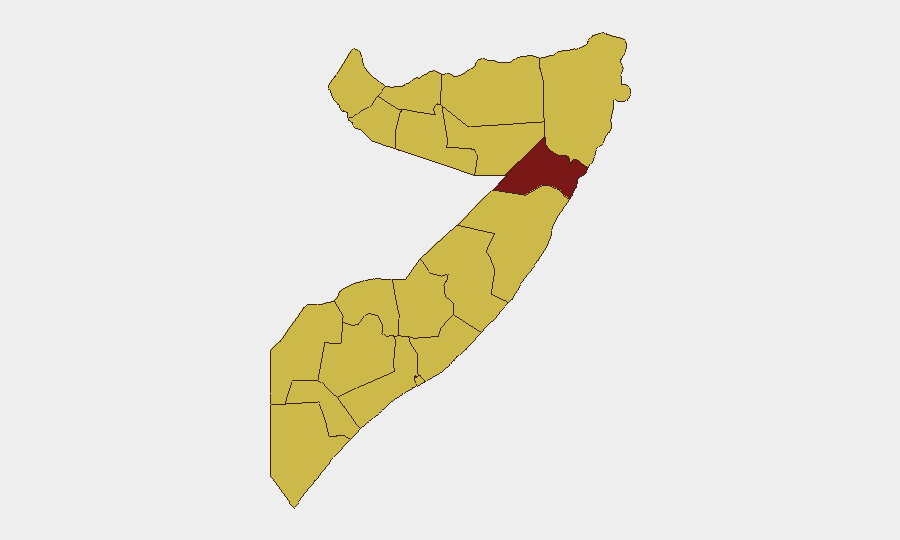
Nugaal dominates the sub-national ranking (96.6) and remains the primary driver of Somalia's global threat score. However, the current operational intensity is concentrated in central and southern regions: Lower Shabelle and Middle Shabelle are the acute flashpoints, with Lower Shabelle hosting the contested Sabiid Bridge logistics corridor and Middle Shabelle the site of both NISA counter-operations and ongoing al-Shabaab activity. Hiiraan and Bakool round out the high-activity zone. The disparity between Nugaal's ranking and current tactical focus likely reflects al-Shabaab's distributed geographic presence and Nugaal's historically limited state capacity; the rankings should be read alongside live event density, which is currently heaviest south and central.
How GeoBit Would Assist
Security teams operating in Somalia should employ AOI Monitoring & Early Warning for persistent watch on the Afgooye–Mogadishu corridor, Jowhar area, and known al-Shabaab operational nodes to receive alerts ahead of major clashes. Battle Mapping and Force Structure analysis would clarify government and militant dispositions around Sabiid Bridge and Sabuun Bridge to support movement planning. OSINT fusion, X/Telegram monitoring, and sentiment analysis would track al-Shabaab and government claims and counter-claims in real time, enabling rapid validation of incident reports and casualty claims that often lag official confirmation.
7-Day Outlook
Government counter-operations against al-Shabaab media and command infrastructure are likely to continue, generating retaliatory militant attacks on fixed and mobile targets in Lower and Middle Shabelle. The Afgooye–Mogadishu corridor will remain a contested zone; transit risk is elevated. No major force repositioning or negotiated pause is anticipated in the next seven days.
Highest-Risk Areas — Ranked
| # | State / Region | Risk |
|---|---|---|
| 1 | Nugaal | 96.6 |
| 2 | Awdal | 66.6 |
| 3 | Woqooyi Galbeed | 66.6 |
| 4 | Gedo | 66.6 |
| 5 | Bakool | 66.6 |
| 6 | Bay | 66.6 |
| 7 | Middle Juba | 66.6 |
| 8 | Lower Shabelle | 66.6 |
| 9 | Sahil | 66.6 |
| 10 | Togdheer | 66.6 |
| 11 | Hiiraan | 66.6 |
| 12 | Middle Shebelle | 66.6 |
Sources
Previous Daily Briefs
A new Somalia brief is written every day — each with its own risk map and downloadable CSV. Here's the last week; use the calendar to go further back.
📅 Browse every day by calendar →
Highlighted days have a brief. Tap a day for that day's map & analysis, or “csv” for that day's dataset ($5).
Atlas — our AI intelligence desk — emails them this snapshot personally. Nothing else, no list.