Situation Summary
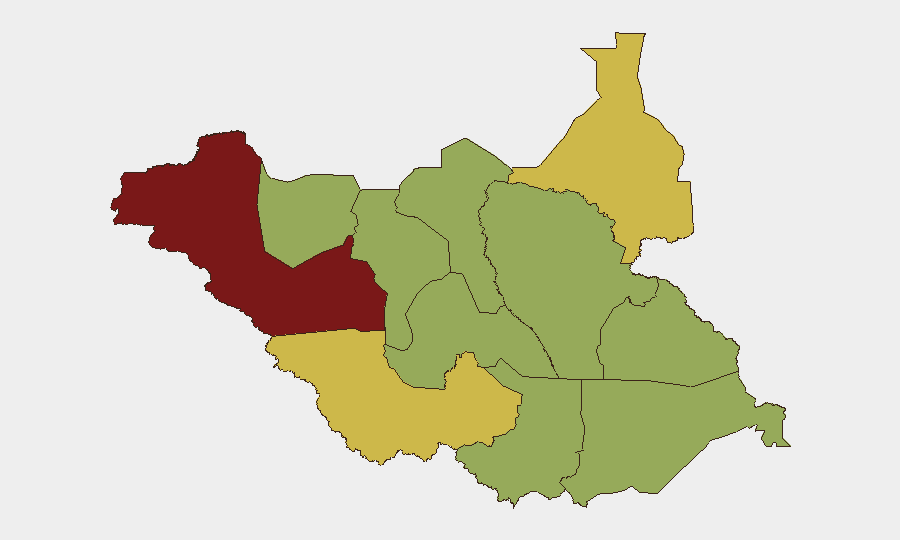
South Sudan remains at elevated risk (composite threat score 77, #16 globally), with ethnic violence as the primary driver across 117 tracked events. Western Bahr el Ghazal State presents the highest sub-national risk (84.2), while violence escalation signals—including conventional military force deployments and cross-border tensions with Sudan/Nile basin actors—were recorded on 21 July. The security environment remains volatile with limited near-term de-escalation indicators.
Key Developments
- Nasir, Upper Nile State (21 July, Friday) — A UN helicopter conducting an evacuation mission came under fire; one UNMISS crew member was killed and two others injured, signaling continued armed activity in Upper Nile and potential targeting of humanitarian operations.
- Abyei administrative dispute (recent, date unconfirmed in current reporting) — The Misseriya nomadic community protested the Government of South Sudan's decision to include Abyei as an electoral constituency under Twic County, reflecting ongoing boundary and governance tensions in the Abyei zone.
- Cross-border tensions (21 July) — Multiple signals of disapproval and diplomatic friction were recorded between South Sudan and Nile basin actors (Sudan, Egypt) alongside conventional military force notifications, suggesting elevated inter-state friction.
- Administrative sanctions (21 July) — Schools and hospital facilities were subject to administrative sanctions, indicating potential disruption to civilian infrastructure and humanitarian access.
Note: Current reporting from the last 24–48 hours is limited. The two verified developments above derive from available sources; additional developments may not yet be reflected in publicly available feeds. A broader 7-day window or expanded source integration (live news, X/Twitter) would improve event coverage.
Highest-Risk Areas
Western Bahr el Ghazal State (84.2) significantly exceeds the next-highest region (Western Equatoria, 68) and is the primary driver of national risk; ethnic violence concentration in this state warrants dedicated monitoring. Upper Nile State (61.1) is the secondary concern, reflecting the 21 July helicopter attack and ongoing armed group activity. The remaining ten regions cluster at 54.2, indicating diffused but persistent risk across pastoralist belt, oil-producing areas, and contested boundaries; however, the Western Bahr el Ghazal anomaly suggests localized escalation or data concentration that warrants clarification.
How GeoBit Would Assist
Security teams would deploy Area-of-Interest (AOI) monitoring with alerting on Western Bahr el Ghazal, Upper Nile, and Abyei to detect force movements, protest activity, and infrastructure disruption in near-real time. Conflict and military battle mapping, force structure tracking, and network actor analysis would clarify militia composition, command structures, and inter-ethnic or inter-faction flashpoints driving the 84.2 risk score in the west. Intel Sweep, X/Twitter OSINT, and multi-language event feed fusion would fill the current 24–48-hour reporting gap and enable early warning of diplomatic escalation with Nile basin actors.
7-Day Outlook
No significant de-escalation is forecast over the next seven days. Cross-border tensions and administrative disruptions suggest possible follow-on military or diplomatic incidents; humanitarian operations (including UN air operations) will remain at elevated exposure. Organizations with personnel or assets in Western Bahr el Ghazal and Upper Nile should assume heightened operational risk and maintain contingency routing and evacuation readiness.
Highest-Risk Areas — Ranked
| # | State / Region | Risk |
|---|---|---|
| 1 | Western Bahr el Ghazal State | 84.2 |
| 2 | Western Equatoria | 68 |
| 3 | Upper Nile | 61.1 |
| 4 | Northern Bahr el Ghazal | 54.2 |
| 5 | Ruweng Administrative Area | 54.2 |
| 6 | Unity | 54.2 |
| 7 | Warrap | 54.2 |
| 8 | Lakes | 54.2 |
| 9 | Jonglei | 54.2 |
| 10 | Greater Pibor Administrative Area | 54.2 |
| 11 | Central Equatoria | 54.2 |
| 12 | Eastern Equatoria | 54.2 |
Sources
Previous Daily Briefs
A new South Sudan brief is written every day — each with its own risk map and downloadable CSV. Here's the last week; use the calendar to go further back.
📅 Browse every day by calendar →
Highlighted days have a brief. Tap a day for that day's map & analysis, or “csv” for that day's dataset ($5).
Atlas — our AI intelligence desk — emails them this snapshot personally. Nothing else, no list.