Situation Summary
Suriname presents a stable security environment in the 24–48 hour window of 2 August 2026, with no verified new incidents reported across national news aggregators, threat feeds, or open-source intelligence. The country's composite threat score remains low (4/100 globally), and no discrete events have been recorded in the current reporting period. Routine lower-level crime and internal migration/trafficking pressures continue, particularly in remote interior regions, but without newly reported escalation or major incidents in the specified timeframe.
Key Developments
- No verified incidents reported, 1–2 August 2026. Cross-referenced monitoring of Suriname Nieuws Centrale, SRNieuws, Waterkant, and Suriname Times confirms an absence of new security, crime, civil-unrest, or infrastructure events in the last 24–48 hours. The most recent tracked incident (police investigation and small-arms matter) dates to 2 July 2026, more than four weeks prior.
- News cycle stability across all monitored districts. National news feeds show no August 1–2 postings for crime, robbery, assault, traffic fatality, or political-instability items; the latest reported incidents in open sources are dated late July (e.g., a 28 July extortion case) or late June, indicating no acute developments in the current window.
- No imminent escalation indicators. GeoBit's Suriname threat assessment for early August notes the absence of indicators pointing to near-term instability, major criminal or political events, or infrastructure failures within the 24–48 hour band.
Highest-Risk Areas
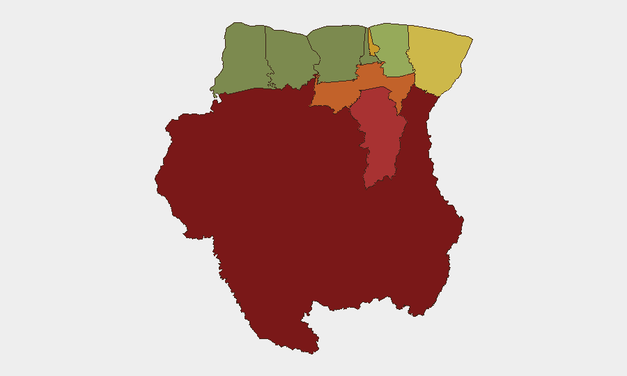
Sipaliwini (risk 92), Brokopondo (78), and Para (74) dominate the sub-national risk landscape and reflect the interior mining, logging, and remote-area vulnerabilities—including limited state presence, trafficking routes, and armed-group activity in border zones. Paramaribo (71) and Marowijne (68) carry elevated risk due to urban crime, gang presence, and cross-border instability with French Guiana. Coastal and northern districts (Commewijne, Wanica, Saramacca, Coronie, Nickerie) present significantly lower risk profiles, with Nickerie (8) the safest tracked area. Organizations with personnel or assets in Sipaliwini, Brokopondo, or Paramaribo should apply heightened duty-of-care protocols.
How GeoBit Would Assist
Corporate security teams would deploy AOI Monitoring & Early Warning to track high-risk districts (Sipaliwini, Brokopondo, Paramaribo) for emerging incidents, combined with Intel Sweep and multi-language OSINT (Portuguese, Spanish, Dutch) to ingest local news, social media, and Telegram channels ahead of mainstream reporting. Risk & Threat Assessment and Routing & Network Analysis capabilities would support contingency planning, alternative-route identification, and rapid duty-of-care response in event of unexpected escalation in interior or urban zones.
7-Day Outlook
No indicators suggest material change in Suriname's threat profile over the next seven days. Seasonal patterns and structural crime/trafficking pressures are expected to persist in interior and border regions; coastal and capital-area operations should remain operationally viable under standard risk protocols. Security teams should maintain baseline monitoring and alert thresholds for any sudden shift in interior activity or crime reporting.
Highest-Risk Areas — Ranked
| # | State / Region | Risk |
|---|---|---|
| 1 | Sipaliwini | 92 |
| 2 | Brokopondo | 78 |
| 3 | Para | 74 |
| 4 | Paramaribo | 71 |
| 5 | Marowijne | 68 |
| 6 | Commewijne | 42 |
| 7 | Wanica | 38 |
| 8 | Saramacca | 29 |
| 9 | Coronie | 12 |
| 10 | Nickerie | 8 |
Sources
- geobit.ai
- shoeket.com
- shoeket.com
- srnieuws.com
- surinamenieuwscentrale.com
- miragenews.com
- surinamenieuwscentrale.com
- surinamenieuwscentrale.com
- surinametimes.com
- surinamenieuwscentrale.com
- surinamesuntimes.com
- surinamenieuwscentrale.com
- surinamenieuwscentrale.com
- surinamenieuwscentrale.com
- srnieuws.com
- surinametimes.com
- whitehouse.gov
- tjaglcs.army.mil
Previous Daily Briefs
A new Suriname brief is written every day — each with its own risk map and downloadable CSV. Here's the last week; use the calendar to go further back.
📅 Browse every day by calendar →
Highlighted days have a brief. Tap a day for that day's map & analysis, or “csv” for that day's dataset ($5).
Atlas — our AI intelligence desk — emails them this snapshot personally. Nothing else, no list.