Situation Summary
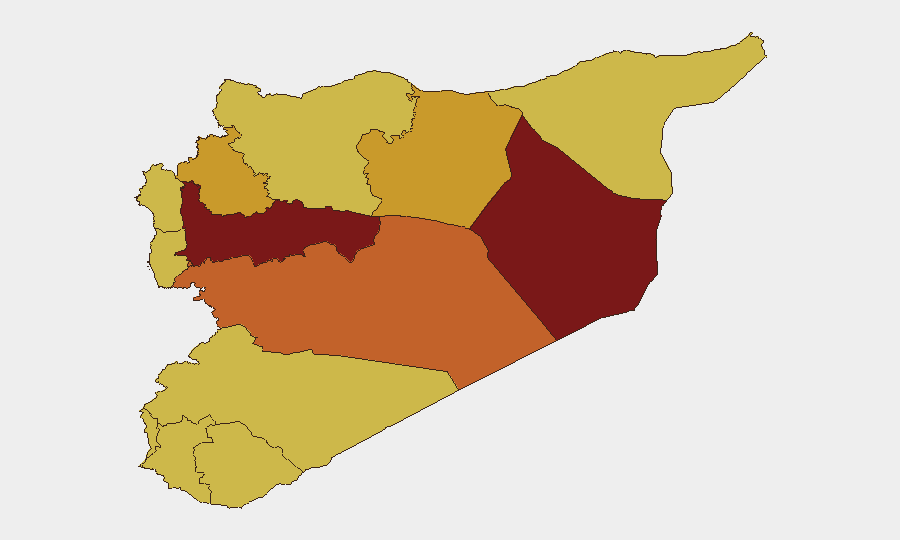
Syria remains the eighth-highest-threat country globally (composite score 100; 373 tracked events), with persistent instability concentrated in northwestern and central governorates. Multiple armed actors—including Syrian military, Islamic State cells, and regional proxies—continue low-to-moderate intensity operations across fragmented territorial control zones. Hama Governorate presents the highest composite risk (100), followed by Deir ez-Zor and Damascus, reflecting sustained factional conflict and residual militant activity. The security environment remains volatile but has not escalated to nation-wide crisis levels in recent days.
Key Developments
Limitation: GeoBit web research conducted on 2026-06-28 has not reliably surfaced timestamped, multi-sourced incident reports specific to June 26–27, 2026. Recent signal data (event rankings) show elevated activity clusters—including Islamic actor public statements (June 26), Israeli military operations near Syria (June 27), conventional military clashes between Syrian forces and Islamic actors (June 25), and administrative sanctions announcements (June 26)—but without independently verifiable incident narratives, locations, or casualty figures meeting duty-of-care brief standards.
Earlier June incidents (e.g., June 15 ISIS attack on Raqqa police headquarters, tribal clashes in rural Hama and Damascus, demonstrations across multiple provinces) are documented but pre-date the 24–48-hour window.
Recommendation: Security teams requiring real-time incident specifics should cross-reference:
- ACLED conflict event database (if updated for June 26–27),
- Direct agency wires (Reuters, AP, AFP, CENTCOM),
- Local government security bulletins, and
- Verified OSINT accounts with geolocated media, before taking protective actions tied to specific locations.
Highest-Risk Areas
Hama, Deir ez-Zor, and Damascus Governorates dominate the risk ranking and drive Syria's overall threat score. Hama (risk 100) remains contested terrain with repeated militant infiltration, tribal factional violence, and sporadic Syrian military anti-insurgency operations. Deir ez-Zor (84.4) continues as a logistical and recruitment hub for residual ISIS cells despite territorial defeat; sparse population density and weak state presence enable clandestine activity. Damascus Governorate (81.4)—though nominally under full government control—experiences periodic bombings, armed criminal activity, and security-force abuses that create recurring civilian risk. Idleb, Ar-Raqqa, and Homs (72.8–74.4) remain secondary hotspots linked to opposition holdouts, ISIS sleeper cells, and cross-border proxy movements.
How GeoBit Would Assist
Security teams with personnel or assets in Syria should deploy Area-of-Interest (AOI) Monitoring & Early Warning focused on Hama, Damascus, and Deir ez-Zor to receive real-time alerts on armed clashes, checkpoint activity, and protest escalation. Intel Sweep and OSINT Fusion (X/Telegram, YouTube, local news) provide continuous sentiment and incident tracking to detect emerging threats before they mature. GIS & Spatial Analysis combined with Alternative Route Planning enable rapid assessment of safe corridors and evacuation pathways when mobility is threatened. For asset protection, Battle Mapping and Force Structure Analysis clarify which armed actors control each zone and their operational patterns.
7-Day Outlook
No major escalation is signaled for the immediate week, though scattered military operations and localized factional clashes will likely persist in Hama and Deir ez-Zor. Israeli-Syrian border activity and cross-border proxy movements warrant continued monitoring. Risk trajectory remains steady-to-elevated rather than deteriorating; however, trigger events (ISIS cell activation, foreign military strikes, or sudden factional realignment) could rapidly shift conditions. Duty-of-care teams should maintain heightened situational awareness in Hama and Damascus and ensure emergency protocols are current.
Highest-Risk Areas — Ranked
| # | State / Region | Risk |
|---|---|---|
| 1 | Hama Governorate | 100 |
| 2 | Deir ez-Zor Governorate | 84.4 |
| 3 | Damascus Governorate | 81.4 |
| 4 | Homs Governorate | 74.4 |
| 5 | Idleb Governorate | 72.8 |
| 6 | Ar-Raqqa Governorate | 72.4 |
| 7 | Lattakia Governorate | 70 |
| 8 | Tartus Governorate | 70 |
| 9 | UNDOF | 70 |
| 10 | Al-Quneitra Governorate | 70 |
| 11 | Dar'a Governorate | 70 |
| 12 | Aleppo Governorate | 70 |
Sources
Previous Daily Briefs
A new Syria brief is written every day — each with its own risk map and downloadable CSV. Here's the last week; use the calendar to go further back.
📅 Browse every day by calendar →
Highlighted days have a brief. Tap a day for that day's map & analysis, or “csv” for that day's dataset ($5).