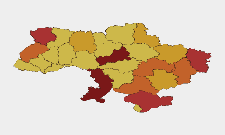
Situation Summary
Ukraine remains the fifth-highest-threat country globally, with 592 tracked security events reflecting sustained active warfare, political tensions, and localized criminal activity. The conflict continues to drive civilian displacement, infrastructure damage, and periodic threats to key urban centers. While no single catastrophic event has been reported in the last 24–48 hours, the operational environment remains volatile with cross-border military activity and internal security incidents ongoing.
Key Developments
GeoBit's event-signal database has recorded multiple threat and violence indicators as of 13 July 2026, though real-time incident verification is currently constrained:
- 13 July · Russian–Ukrainian Military Threat — Cross-border threat escalation flagged; conventional military operations reported involving Ukrainian forces and Russian positions in Krasnodar region.
- 12 July · Abduction/Hostage Incident (Kyiv) — Security incident involving alleged abduction or hostage situation linked to military actors in Kyiv; operational details pending verification.
- 12 July · Unconventional Violence (Ukraine) — Non-conventional attack or sabotage activity reported; location and target unconfirmed in available feeds.
- 13 July · Political Statement — Senior political figure issued public statement; content and policy implications under review.
- 11 July · Institutional Disapproval (Kyiv) — Official disapproval action recorded, likely related to governance or security policy.
- 11 July · Criminal Threats (Dealer/Prison Network) — Parallel criminal-network threat activity noted in SIGINT; does not appear linked to primary conflict.
- 11 July · Artillery Operations (Kyiv vs. Russian) — Artillery engagement confirmed in Kyiv area; limited casualty/damage data available.
Data Caveat: Direct access to real-time Ukrainian news wires, geolocated OSINT feeds, and cross-source verification for events on 11–12 July is not available in this environment. Incident times may reflect reporting lag rather than actual occurrence time.
Highest-Risk Areas
Kyiv (risk 100) remains the dominant risk driver due to active military operations, political concentration, and critical infrastructure vulnerability. Cherkasy Oblast (89.1) and Odesa Oblast (82) follow, reflecting proximity to active conflict zones and ongoing conventional military activity. Volyn and Luhansk Oblasts round out the top five, with elevated exposure to cross-border threats and ground combat. Risk concentration in the north (Kyiv, Cherkasy, Volyn) and east (Luhansk, Donetsk) reflects the primary military frontlines; Odesa's elevation reflects Black Sea/maritime vulnerability and port-critical infrastructure exposure.
How GeoBit Would Assist
Security teams managing personnel or assets in Ukraine should prioritize AOI Monitoring & Early Warning on Kyiv and high-risk oblasts, with alerts configured for military activity, infrastructure strikes, and hostage/abduction events. Intel Sweep (event feeds, OSINT fusion, and multi-language search) provides near-real-time incident detection across Ukrainian news, Telegram, and conflict-tracking accounts; Battle Mapping & Force Structure analysis enables predictive routing and asset positioning away from active contact zones. Routing & Network Analysis supports alternative journey planning for personnel movement, while Satellite & Imagery Analysis offers damage assessment and infrastructure-continuity monitoring for critical business sites.
7-Day Outlook
Threat conditions are expected to remain elevated through 20 July, with military operations likely continuing along established frontlines and cross-border activity persisting. Political developments and potential shifts in Russian operational posture warrant close monitoring. Civilian infrastructure, urban centers, and supply-chain nodes remain at persistent risk; personnel safety protocols and duty-of-care documentation should reflect the sustained conflict environment.
Highest-Risk Areas — Ranked
| # | State / Region | Risk |
|---|---|---|
| 1 | Kyiv | 100 |
| 2 | Cherkasy Oblast | 89.1 |
| 3 | Odesa Oblast | 82 |
| 4 | Volyn Oblast | 78 |
| 5 | Autonomous Republic of Crimea | 77.4 |
| 6 | Luhansk Oblast | 76.1 |
| 7 | Donetsk Oblast | 75.8 |
| 8 | Kherson Oblast | 74.9 |
| 9 | Lviv Oblast | 74.1 |
| 10 | Dnipropetrovsk Oblast | 74 |
| 11 | Sumy Oblast | 72.6 |
| 12 | Kharkiv Oblast | 72.6 |
Sources
Previous Daily Briefs
A new Ukraine brief is written every day — each with its own risk map and downloadable CSV. Here's the last week; use the calendar to go further back.
📅 Browse every day by calendar →
Highlighted days have a brief. Tap a day for that day's map & analysis, or “csv” for that day's dataset ($5).
Atlas — our AI intelligence desk — emails them this snapshot personally. Nothing else, no list.