Situation Summary
Venezuela remains at composite threat rank #41 globally, with acute instability concentrated in the earthquake-affected north-central corridor following the 24 June seismic event. Post-disaster operations—involving 29,567 deployed military and security personnel, 87 temporary displacement camps, and ongoing aftershock activity—are creating significant infrastructure strain, humanitarian crowding, and localized movement controls. Political risk is escalating as the quake response becomes a test of governance credibility for acting President Delcy Rodríguez, with emerging commentary on potential authority centralization and security-force posture linked to the emergency.
Key Developments
- La Guaira and northern coastal zone (Jul 8–9): Authorities have relocated 17,907 people to 87 temporary camps and are providing direct assistance to 86,794 families; displacement-driven crowding and resource-distribution points remain active operational and logistics risk factors.
- Northern Venezuela, multi-municipality (Jul 8–9): Funvisis recorded more than a dozen earthquakes (magnitude 2.6–4.0) in the last 24 hours; cumulative aftershock count stands at 1,076 since 24 June, with 856 buildings damaged and 190 destroyed, sustaining structural compromise of transport and utility infrastructure.
- Caracas–La Guaira corridor and surrounding states (Jul 8–9): Large-scale search-and-rescue and security deployment ongoing, including 29,567 military and police personnel plus volunteer corps and a specialized 200-member mining team for body recovery; checkpoints and movement controls remain in effect.
- North-central coastal zone (Jul 8–9): Government reports 3,685 deaths, 16,740 injuries, and over 30,000 citizen-logged missing-person reports; 25,970 patients processed through health centers, sustaining infrastructure strain and crowding-related protest risk at medical and relief sites.
- North-central coastal corridor (Jul 8–9): 9,603 metric tons of food and 8,322,853 liters of drinking water delivered in ongoing relief operations; aid-convoy concentration and distribution-point crowding present travel and operational friction points.
- National political arena (Jul 8–9): Acting President Rodríguez's quake-response management has become a focus for criticism and political-stability commentary; analytical sources flag risk of emergency-regulation use for authority centralization and security tightening.
- Presidential statement (Jul 10): Most recent event signal indicates a public statement from the president; detailed content not yet available but likely related to ongoing quake operations or political narrative management.
Highest-Risk Areas
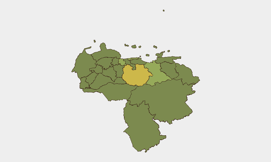
Guarico State (64), Federal District (52.6), and Carabobo State (50.8) lead the sub-national ranking. The concentration of risk in Guarico and the Federal District reflects both earthquake-zone proximity and the political-stability test unfolding in Caracas; Carabobo's elevated score reflects historical lawlessness and gang activity. Vargas and Anzoategui States, both in the quake-affected coastal corridor, remain elevated due to infrastructure damage, displacement camps, and active military presence. Together, these five states account for the bulk of current corporate exposure to seismic aftershock, humanitarian-operations friction, and emerging governance-stability risk.
How GeoBit Would Assist
Real-time AOI Monitoring & Early Warning focused on Guarico, Federal District, and the coastal corridor would provide persistent watch of checkpoint deployment, camp activity, and relief-convoy movement. Routing & Network Analysis and GIS & Spatial Analysis capabilities enable security teams to model alternative transport routes, assess infrastructure damage impact on supply chains, and identify safe passage windows around displacement zones and military checkpoints. Early Warning & Prediction models—drawing on event-signal feeds, sentiment analysis, and regime-stability indicators—can flag political friction points or protest risk before they escalate.
7-Day Outlook
Aftershock activity and humanitarian operations will remain the dominant security driver in the north-central corridor over the coming week. Political scrutiny of the quake response is likely to intensify, raising short-term risk of demonstrations or security-force repositioning around Caracas. Travel, logistics, and site operations in Vargas, Carabobo, and the Federal District should remain on elevated watch; alternative routing and contingency staffing planning are advisable.
Highest-Risk Areas — Ranked
| # | State / Region | Risk |
|---|---|---|
| 1 | Guarico State | 64 |
| 2 | Federal District | 52.6 |
| 3 | Carabobo State | 50.8 |
| 4 | Anzoategui State | 42.8 |
| 5 | Vargas State | 41.3 |
| 6 | Lara State | 34.9 |
| 7 | Falcon State | 34.3 |
| 8 | Merida State | 34.3 |
| 9 | Tachira State | 34.3 |
| 10 | Zulia State | 34 |
| 11 | Federal Dependencies | 34 |
| 12 | Nueva Esparta State | 34 |
Sources
Previous Daily Briefs
A new Venezuela brief is written every day — each with its own risk map and downloadable CSV. Here's the last week; use the calendar to go further back.
📅 Browse every day by calendar →
Highlighted days have a brief. Tap a day for that day's map & analysis, or “csv” for that day's dataset ($5).
Atlas — our AI intelligence desk — emails them this snapshot personally. Nothing else, no list.