Situation Summary
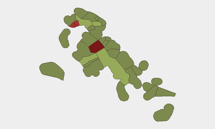
The Bahamas faces a persistent but geographically concentrated violent-crime challenge, with New Providence (Nassau) accounting for the majority of recent incidents and driving the nation's composite threat ranking of 21 globally. A cluster of six shootings across three separate incidents on 2026-08-10 and 2026-08-11 underscores ongoing gang-related or territorial violence in the capital; two arrests have been made in connection with this wave. While the broader archipelago remains lower-risk outside the capital and Freeport, the concentration of firearm availability and violent incidents in New Providence presents a sustained threat to corporate operations, expatriate personnel, and transiting assets.
Key Developments
- New Providence (Nassau), 2026-08-10 to 2026-08-11: Six people shot in three separate incidents over 48 hours; one 27-year-old male hospitalized following chest surgery. Two arrests made on 2026-08-09 and linked to the same violence cluster by local law enforcement.
- Jasmine Lane off Royal Palm Street, Nassau, 2026-08-09: Police discovered one firearm and ammunition wrapped in a blue shirt during a targeted operation; weapon was seized.
- Amos Ferguson Street, Nassau, 2026-08-08: A 17-year-old male arrested for illegal firearm and ammunition possession following a residential search.
- Grand Bahama (Scott Street), 2026-08-07–08: Three men aged 24–26 arrested in a drug bust; officers recovered approximately 1.3 pounds of hydroponic marijuana and $3,295 in cash.
- Nichols Town, Andros, 2026-08-09: Police responded to an attempted suicide involving an 18-year-old woman; incident reflects broader mental-health and welfare concerns in Family Islands.
Highest-Risk Areas
New Providence (risk 92) and the City of Freeport (risk 78) dominate the sub-national threat picture and account for the vast majority of tracked violent incidents, gang activity, and firearm-related crime. The recent shooting cluster in Nassau's West Bay Street corridor and ongoing drug-trafficking activity in Freeport indicate that organized criminal networks remain active in both urban centers. Central Abaco (risk 52) and Central Andros (risk 48) show elevated but substantially lower risk; the Family Islands generally exhibit scores below 50, suggesting that threat concentration in the capital and northern hub is acute rather than archipelago-wide. Corporate teams operating outside Nassau and Freeport face materially lower exposure to violent crime, though localized governance and infrastructure gaps remain.
How GeoBit Would Assist
Security and duty-of-care teams can employ AOI Monitoring & Early Warning to track New Providence and Freeport neighborhoods in real time, triggering alerts when violence clusters emerge near corporate offices, residences, or transit corridors. OSINT Fusion & Corroboration and multi-language search capabilities enable continuous scan of local broadcast, social media, and police reports to distinguish genuine threats from rumors and to assess perpetrator intent and targeting patterns. Network & Actor Analysis supports identification of gang and criminal-group activity across the archipelago, helping security teams assess whether specific incidents signal escalation or territorial shifts affecting personnel safety.
7-Day Outlook
The recent six-shootings cluster suggests sustained gang violence in Nassau rather than a singular spike, with arrests unlikely to produce immediate de-escalation. Personnel and asset managers in New Providence should maintain heightened situational awareness, restrict movement in West Bay Street and downtown areas during evening and night hours, and coordinate with local law enforcement for real-time incident briefings. No evidence of spillover into Family Islands or Freeport has emerged; however, continued drug-trafficking arrests in Grand Bahama warrant monitoring for supply-chain disruptions or territorial disputes.
Highest-Risk Areas — Ranked
| # | State / Region | Risk |
|---|---|---|
| 1 | New Providence | 92 |
| 2 | City of Freeport | 78 |
| 3 | Central Abaco | 52 |
| 4 | Central Andros | 48 |
| 5 | Exuma | 45 |
| 6 | East Grand Bahama | 42 |
| 7 | South Andros | 38 |
| 8 | North Abaco | 35 |
| 9 | North Eleuthera | 33 |
| 10 | South Abaco | 32 |
| 11 | Cat Island | 30 |
| 12 | Mangrove Cay | 28 |
Sources
Previous Daily Briefs
A new Bahamas brief is written every day — each with its own risk map and downloadable CSV. Here's the last week; use the calendar to go further back.
- August 11, 2026
- August 10, 2026
- August 9, 2026
- August 8, 2026
- August 7, 2026
- August 6, 2026
- August 5, 2026
📅 Browse every day by calendar →
Highlighted days have a brief. Tap a day for that day's map & analysis, or “csv” for that day's dataset ($5).
Atlas — our AI intelligence desk — emails them this snapshot personally. Nothing else, no list.