Situation Summary
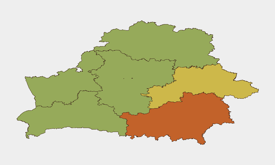
Belarus remains a low-threat environment globally (rank #131, composite score 10) with no confirmed large-scale protests, armed clashes, or terror incidents in the current reporting window. However, regional disparities are pronounced: Homyel Region (risk 75) and Minsk (risk 68) carry significantly elevated threat profiles, driven by border proximity, infrastructure stress, and security-force posture. The country is experiencing manageable, localized disruptions—airport delays from Russian airspace restrictions, routine wildfire activity, and standard border-migration pressure—rather than systemic instability. Current trajectory suggests continued stability with operational friction from external spillover effects (Russian airspace closures, transit disruption).
Key Developments
- Minsk National Airport flight delays (30 August, 06:00–12:00 local): Widespread delays and rescheduling of flights to Moscow, St. Petersburg, Dubai, and Antalya due to Russian airspace restrictions imposed after mass drone activity and claimed interception of ~500 drones. Onward connections through Russia are unstable, affecting passenger transit and logistics chains.
- Emergency vehicle incident in Minsk (30 August): Fire ladder truck caught fire en route to Loshytski Lane; driver escaped unharmed. A separate private house fire was reported the same day. No casualties; incident reflects operational strain on emergency services.
- Wildfire activity across Belarus (29–30 August, 06:00–06:00 window): Emergency services extinguished 12 forest fires (2.52 ha) and 17 grass/shrub fires (1.99 ha). May affect air quality, rural travel, and forested-area access.
- Border migration pressure at Lithuanian–Belarusian frontier (30 August, last 24h): Eight irregular migrants turned back by Lithuania's State Border Guard Service. Suggests ongoing cross-border migration attempts and heightened border monitoring.
- Enhanced school-term security measures (30 August announcement): Official sources indicate plans to "bolster public order at school on 1 September," implying increased law-enforcement visibility around educational institutions. No specific unrest reported; appears to be routine measure tied to academic calendar.
- US Special Envoy statement on political-prisoner releases (30 August): US envoy claims potential for releasing up to 300 jailed dissidents by mid-September, including high-profile 2020 protest participants. Reflects ongoing diplomatic engagement on human-rights issues; no current unrest documented.
- Belarusian MFA consular statement (30 August): No Belarusian casualties reported in connection with vessel incident near Northern Cyprus. Routine consular update.
Highest-Risk Areas
Homyel Region (risk 75) and Minsk (risk 68) dominate the sub-national risk landscape, reflecting proximity to Ukrainian and Russian borders, infrastructure concentration, and heightened security-force activity. Mahilyow Region (62) and Brest Region (55) follow, likely driven by border exposure and transit routes. Eastern and southern regions carry materially higher threat profiles than western and northern zones (Vitsebsk, 45; Hrodna, 52). Risk clustering correlates with proximity to active conflict zones and strategic infrastructure rather than domestic unrest.
How GeoBit Would Assist
Security teams with operations or personnel in Belarus should deploy AOI Monitoring & Early Warning on Homyel, Minsk, and Mahilyow to detect emerging unrest, border incidents, or infrastructure failures in real time. Aviation & Maritime tracking combined with alternative-route planning (Routing & Network Analysis) can help re-route staff and supply chains around Russian airspace disruptions and border checkpoints. OSINT fusion (multi-language Telegram/X monitoring, conflict event feeds) provides early signals on protest activity, regime messaging, or cross-border military movements before they escalate.
7-Day Outlook
No escalation to mass unrest or security crises is anticipated over the next seven days. Near-term focus should remain on transit disruption via Russian airspace, routine border-migration management, and school-term security posture. If Russian drone activity intensifies, secondary spillover (airport closures, supply-chain delays) remains the primary operational risk to corporate presence in Belarus.
Highest-Risk Areas — Ranked
| # | State / Region | Risk |
|---|---|---|
| 1 | Homyel Region | 75 |
| 2 | Minsk | 68 |
| 3 | Mahilyow Region | 62 |
| 4 | Brest Region | 55 |
| 5 | Hrodna Region | 52 |
| 6 | Minsk Region | 48 |
| 7 | Vitsebsk Region | 45 |
Sources
Previous Daily Briefs
A new Belarus brief is written every day — each with its own risk map and downloadable CSV. Here's the last week; use the calendar to go further back.
- August 28, 2026
- August 26, 2026
- August 24, 2026
- August 22, 2026
- August 20, 2026
- August 18, 2026
- August 15, 2026
📅 Browse every day by calendar →
Highlighted days have a brief. Tap a day for that day's map & analysis, or “csv” for that day's dataset ($5).
Atlas — our AI intelligence desk — emails them this snapshot personally. Nothing else, no list.