Situation Summary
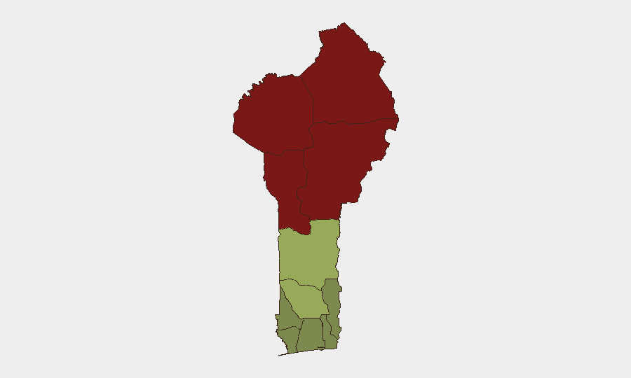
Benin faces a persistent two-tier security landscape: the northern border regions (Alibori, Atakora, Borgou, Donga departments) remain under sustained terrorist and trafficking pressure, while major urban centers experience elevated conventional crime. As of 30 July 2026, no major new attacks or unrest have been reported in the last 24–48 hours, but ongoing law-enforcement operations and cross-border monitoring indicate active threat management rather than de-escalation. The country's composite threat score remains low globally, but sub-national risk is heavily concentrated in the north.
Key Developments
- Explosives seizure (Northern Benin, 29 July 2026): Customs authorities reported interception of approximately 3,295 sticks of explosives (~500 kg) at Anoum checkpoint on the Sonahoulou–Djougou axis (northern Borgou/Donga region). The shipment was traced to Togo and destined for Malanville. An active investigation has been opened to identify trafficking networks and beneficiaries, signaling serious security-service concern about terrorist procurement.
- Coordinated smuggling interdictions (Northern border, 29 July 2026): Parallel seizures reported across northern departments: 3,000 hunting cartridges in Borgou, 1,400 kg of smuggled medicines in Couffo, and 5,574 Android phones at Hillacondji checkpoint. The timing and scale suggest either a coordinated enforcement campaign or heightened customs vigilance in response to the explosives case.
- Border military posture assessment (Koualou–Kourou, late July 2026): Social-media imagery of Beninese and Burkinabè troops near the Benin–Burkina Faso border prompted speculation about joint operations. Beninese authorities clarified that Burkinabè repositioning was unilateral, but the incident reflects ongoing sensitivity and active monitoring along this frontier.
- Updated travel advisory reaffirmed (27 July 2026, still current): European advisory services reiterated warnings of terrorist activity, kidnapping risk, and roadblock proliferation in border zones north of Boukoumbé–Natitingou–Kérou–Kandi–Segbana and in Borgou's Kalalé–Nikki corridor, with specific reference to recent incidents in Natitingou surroundings.
- Urban crime persistence (Cotonou and major cities, 27 July 2026 advisory): Formal assessment notes ongoing robberies and pickpocketing at Dantokpa Market, the beach, and port areas, plus motorcycle-taxi-related muggings and accidents on rural roads, confirming sustained conventional crime risk in population centers.
Highest-Risk Areas
The northern four departments—Alibori (92), Atakora (88), Donga (85), and Borgou (83)—account for the majority of Benin's threat landscape, driven by porous borders with Burkina Faso, Niger, and Togo; active terrorist networks; and trafficking in explosives, weapons, and contraband. Zou (45), Collines (42), and Plateau (38) represent a secondary risk tier, while southern coastal departments (Littoral, Ouémé, Atlantique) remain relatively lower-risk but face urban crime. The explosives seizure and coordinated customs operations confirm that northern border zones remain the primary concern for duty-of-care teams.
How GeoBit Would Assist
A security team monitoring Benin would deploy AOI Monitoring & Early Warning to watch Alibori, Atakora, Borgou, and Donga departments for trafficking incidents, roadblocks, and militant activity. Conflict & Military capabilities (force structure, weapons-tracking) and Network & Actor Analysis would map smuggling and terrorist supply chains revealed by customs seizures. Routing & Network Analysis would support alternative-route planning for personnel and supply movements, avoiding high-risk checkpoints and border corridors.
7-Day Outlook
Northern border security operations are likely to intensify as Beninese authorities pursue the explosives trafficking investigation and coordinate with regional partners. Urban crime in Cotonou and other cities will remain steady-state. No major escalation is anticipated in the next week absent new cross-border incidents or terrorist claims.
Highest-Risk Areas — Ranked
| # | State / Region | Risk |
|---|---|---|
| 1 | Alibori Department | 92 |
| 2 | Atakora Department | 88 |
| 3 | Donga Department | 85 |
| 4 | Borgou Department | 83 |
| 5 | Zou Department | 45 |
| 6 | Collines Department | 42 |
| 7 | Plateau Department | 38 |
| 8 | Kouffo Department | 35 |
| 9 | Mono Department | 32 |
| 10 | Atlantique Department | 28 |
| 11 | Littoral | 25 |
| 12 | Ouémé Department | 22 |
Sources
Previous Daily Briefs
A new Benin brief is written every day — each with its own risk map and downloadable CSV. Here's the last week; use the calendar to go further back.
📅 Browse every day by calendar →
Highlighted days have a brief. Tap a day for that day's map & analysis, or “csv” for that day's dataset ($5).
Atlas — our AI intelligence desk — emails them this snapshot personally. Nothing else, no list.