Situation Summary
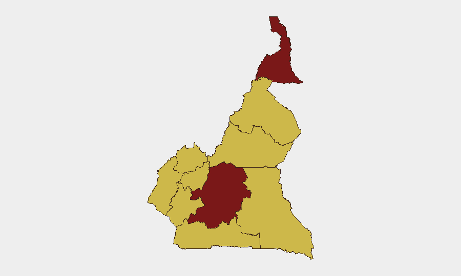
Cameroon faces acute multi-front military stress as of mid-July 2026, with confirmed conventional military operations against internal armed factions, cross-border engagements with Chad and Nigeria, and active national-level force mobilization. The Centre region—home to the capital Yaoundé—carries the highest composite risk score (96.1), reflecting sustained pressure from internal conflict. Overall threat ranking places Cameroon at #21 globally; five tracked events within the assessment window suggest sustained rather than escalating tempo, though data gaps beyond 14 July limit real-time visibility.
Key Developments
- Cameroon–Chad border (sector unspecified) – 14 July 2026
Conventional military engagement between Cameroonian and Chadian forces recorded; precise frontier sector and casualty/scale data remain unconfirmed in open sources.
- Cameroon–Nigeria border (sector unspecified) – 14 July 2026
Multiple instances of conventional military force between Cameroon and Nigerian forces; specific towns and positions not yet publicly identified. Reflects sustained border friction across the western frontier.
- Nationwide (Cameroon) – 14 July 2026
Cameroonian Armed Forces conducted conventional military operations against internal armed factions country-wide; locations and casualty figures unconfirmed but operations span multiple regions.
- National (Cameroon) – 16 July 2026
Military mobilization operations by Cameroon Armed Forces reported; reflects ongoing force movements and readiness posture consistent with multi-front operational tempo.
- Douala, Bonamoussadi neighborhood – night of 11–12 July 2026
Three-storey residential building partially collapsed during heavy rains, killing at least six (including three children) and injuring six others. Relevant to duty-of-care teams: infrastructure vulnerability in high-density urban areas during rainy season; structural safety conditions under investigation.
- National (Cameroon) – 14 July 2026
Civic dissent signal involving medical professional flagged; specific location, grievance, and mode remain unspecified. Contextual note: health-worker intimidation and disruptions in Northwest and Southwest reported as persistent (10 July source) prior to this signal.
- National (Cameroon) – 11 July 2026
Two arrest/detention incidents involving Jamaican nationals and Cameroonian authorities; legal basis and current status unclear. Part of broader enforcement pattern rather than isolated event.
Highest-Risk Areas
Centre region (96.1) dominates the threat profile, driven by proximity to Yaoundé and internal armed-group activity. Far-North (82.1) remains elevated due to ongoing Boko Haram-related pressures and cross-border spillover. The remaining eight regions cluster at 66.1, indicating widespread sub-national stress: Northwest and Southwest face separatist-affiliated violence; Littoral and Adamawa experience cross-border spillover and militant activity; North, East, and South face lower but sustained risk from armed groups and border friction. Risk concentration in Centre and Far-North should drive security planning for personnel and asset concentration in those zones.
How GeoBit Would Assist
Corporate security teams should deploy AOI Monitoring & Early Warning on Centre, Far-North, and border zones (Cameroon–Nigeria, Cameroon–Chad) to capture militia activity and cross-border military contacts in near-real time. Battle Mapping and Force Structure tracking will clarify military unit dispositions and operational objectives as they develop. Multi-language OSINT (X/Twitter, Telegram, local media feeds) and temporal/sentiment analysis enable detection of dissent signals and health-worker pressure before escalation, supporting duty-of-care compliance for medical and NGO staff.
7-Day Outlook
Military operations against internal factions are likely to persist; cross-border friction with Chad and Nigeria may remain intermittent rather than show sustained escalation in the near term. Data gaps beyond 14 July constrain forward prediction; heightened alert posture is warranted for Centre, Far-North, and border regions through end of July.
Highest-Risk Areas — Ranked
| # | State / Region | Risk |
|---|---|---|
| 1 | Centre | 96.1 |
| 2 | Far-North | 82.1 |
| 3 | Northwest | 66.1 |
| 4 | Southwest | 66.1 |
| 5 | West | 66.1 |
| 6 | Littoral | 66.1 |
| 7 | Adamawa | 66.1 |
| 8 | South | 66.1 |
| 9 | North | 66.1 |
| 10 | East | 66.1 |
Sources
Previous Daily Briefs
A new Cameroon brief is written every day — each with its own risk map and downloadable CSV. Here's the last week; use the calendar to go further back.
📅 Browse every day by calendar →
Highlighted days have a brief. Tap a day for that day's map & analysis, or “csv” for that day's dataset ($5).
Atlas — our AI intelligence desk — emails them this snapshot personally. Nothing else, no list.