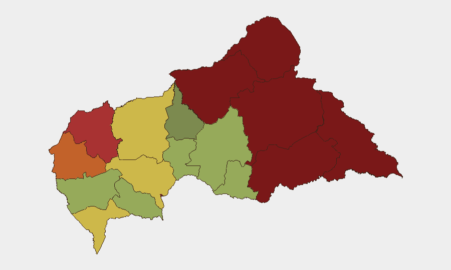
Situation Summary
Central African Republic remains a persistently fragile state (global threat rank #31, composite score 74) with endemic armed-group activity, limited state capacity, and chronic instability in frontier and resource-rich regions. Open-source reporting for the last 24–48 hours shows a notable absence of cross-verified incident-level events (armed clashes, attacks, civil unrest), though this reflects known visibility gaps in Central African conflict reporting rather than genuine security improvement. Baseline risk remains elevated across the northeast and east; corporate and humanitarian operations should maintain standard heightened vigilance and rely on local security networks for real-time alerts rather than assume a lull in violence.
Key Developments
- Reporting Gap (CAR-wide, 27–29 June). Major international news wires, regional security monitors, and open-source feeds do not provide cross-confirmed, time-stamped security incidents or unrest events for Central African Republic in the last 48 hours. This absence likely reflects both a genuine lull and endemic under-reporting of armed activity in remote areas rather than a reduction in threat.
- Fiscal and Governance Signals (29 June). Unconfirmed event data point to tensions between a provincial governor and the Central Bank (relation-reduction event) and separate public criticism of the World Bank by business interests and the presidency. These signals may reflect economic pressure or donor-coordination friction but do not currently translate to operational security incidents.
- Regional Military Activity (28 June). Neighboring Congo is flagged in event feeds for both conventional military posturing and cross-border diplomatic friction (with Kinshasa and Uzbekistan). Spillover risk into CAR border zones (particularly Sangha-Mbaéré and Haut-Mbomou) warrants monitoring, though no direct CAR involvement is yet confirmed.
- Baseline Northeast Volatility. Vakaga and Bamingui-Bangoran (ranked #1 and #2 in sub-national risk) continue to present structural armed-group and trafficking exposure typical of this reporting cycle; no new specific events are flagged but travel and supply-chain risk remains elevated.
Highest-Risk Areas
The northeastern and eastern frontier zones—Vakaga (risk 95), Bamingui-Bangoran (92), Haute-Kotto (88), and Haut-Mbomou (85)—drive overall country risk. These regions are characterized by limited state control, porous borders, armed-group presence, and mineral and wildlife trafficking networks. Bangui (rank 7, risk 78), while more developed and visible, remains vulnerable to civil unrest, petty crime, and political instability. Risk decreases toward the southwest and center (Kémo, Ombella-M'Poko, Ouham) but remains above baseline due to endemic criminality and historical conflict dynamics.
How GeoBit Would Assist
Security teams with personnel or assets in CAR should employ persistent Area-of-Interest (AOI) monitoring and early-warning alerts on Vakaga, Bamingui-Bangoran, and Bangui to catch emerging armed clashes or civil unrest in near-real time. Multi-language OSINT fusion—combining X/Telegram feeds, radio SIGINT, and YouTube incident intelligence—helps overcome the visibility gaps evident in mainstream reporting and provides local context. Conflict and actor network analysis linked to force-structure and border-crossing tracking clarifies spillover risk from Congo and neighboring countries and informs routing and alternative journey planning for staff mobility.
7-Day Outlook
No major escalation is currently signaled for the next week, but the reporting gap and baseline persistence of armed-group activity in the northeast mean that genuine risk remains unquantified. Monitor border zones and provincial capitals for any uptick in military movement, donor-relations friction, or cross-border spillover. Standard enhanced security postures and local-network alerting should remain in place; absence of recent confirmed incidents should not be interpreted as reduced threat.
Highest-Risk Areas — Ranked
| # | State / Region | Risk |
|---|---|---|
| 1 | Vakaga | 95 |
| 2 | Bamingui-Bangoran | 92 |
| 3 | Haute-Kotto | 88 |
| 4 | Haut-Mbomou | 85 |
| 5 | Mbomou | 82 |
| 6 | Ouham-Pendé | 79 |
| 7 | Bangui | 78 |
| 8 | Nana-Mambéré | 75 |
| 9 | Sangha-Mbaéré | 68 |
| 10 | Ouham | 65 |
| 11 | Ombella-M'Poko | 62 |
| 12 | Kémo | 58 |
Sources
Previous Daily Briefs
A new Central African Republic brief is written every day — each with its own risk map and downloadable CSV. Here's the last week; use the calendar to go further back.
📅 Browse every day by calendar →
Highlighted days have a brief. Tap a day for that day's map & analysis, or “csv” for that day's dataset ($5).