Situation Summary
Chad remains a fragmented security environment, ranked #26 globally with a composite threat score of 76. The most acute risks are concentrated in Lac Province (bordering Lake Chad), where a declared state of emergency reflects intensifying armed-group activity, military operations, and large-scale displacement as of early July 2026. The broader Lake Chad Basin has recorded an 80% surge in security incidents between January 2024 and April 2026, with nearly 1,800 incidents and over 5,700 deaths between September 2025 and May 2026, establishing a deteriorating trajectory across the region.
Key Developments
- Lac Province state of emergency (6 July 2026): Chadian authorities declared a state of emergency in parts of Lac Province following repeated armed-group attacks and military operations. UNHCR reporting confirmed approximately 60,000 new displacements as of 6 July 2026, with the situation described as ongoing and worsening in early July.
- Armed-group violence and kidnappings, Lac Province islands (6 July 2026): UN-linked analysis reported continuing attacks, kidnappings, and village raids by non-state armed groups on islands and lakeside communities in western Lac Province. These incidents, combined with Chadian military counter-operations, are documented as the primary driver of displacement in the first week of July 2026.
- Lake Chad Basin cross-border insecurity confirmed (4–6 July 2026): UNHCR and independent security reporting between 4 and 6 July 2026 reinforced the 80% surge in Lake Chad Basin incidents (January 2024–April 2026) and reiterated Lac Province specifically as an active zone of attacks and large-scale population displacement.
- Police-related public statements (6 July 2026): Public statements involving Chad authorities and police issues were issued on 6 July 2026; limited detail is currently available in open-source channels, and GeoBit's event signals do not yet confirm specific operational context.
- Hepatitis E circulation (recent): Health surveillance data indicate ongoing Hepatitis E circulation in Chad; humanitarian organizations continue to monitor disease prevalence in displacement camps and affected communities.
Highest-Risk Areas
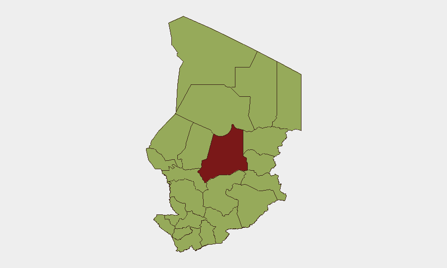
Batha Region (composite risk 83) carries the highest sub-national risk score and requires prioritized monitoring. However, Lac Province and surrounding northern border zones (risk 53 on the indexed scale but demonstrably the epicenter of current violence) represent the most acute operational threat, driven by sustained armed-group activity, military operations, mass displacement, and limited humanitarian access. The secondary-tier regions (Ennedi-Ouest, Wadi Fira, Ouaddaï, Sila, Salamat, Kanem, and Hadjer-Lamis) all register risk 53, reflecting the diffuse nature of insecurity across Chad's periphery. N'Djamena, despite its capital status (risk 53), remains operationally more stable than Lac, though security incidents and personnel safety considerations remain relevant for corporate operations in the city.
How GeoBit Would Assist
Security and risk teams should deploy AOI Monitoring & Early Warning to track Lac Province and border islands for real-time incident alerts, combined with Conflict & Military battle mapping to visualize armed-group and military positions. OSINT fusion (multi-language feeds, X/Twitter, Telegram, and regional humanitarian reporting) will improve incident-level granularity and corroboration speed, particularly where open-source news lags. Network & Actor Analysis can identify armed-group command structures and operational patterns to anticipate displacement flows and security escalation.
7-Day Outlook
Lac Province insecurity is expected to remain elevated through mid-July 2026, with ongoing military operations and armed-group activity likely driving further displacement. Humanitarian access constraints will persist, increasing disease-transmission risk (notably Hepatitis E) in congested camps. No imminent de-escalation signals are evident; monitoring should remain continuous on displacement thresholds and any military repositioning in the border zone.
Highest-Risk Areas — Ranked
| # | State / Region | Risk |
|---|---|---|
| 1 | Batha | 83 |
| 2 | Ennedi-Ouest | 53 |
| 3 | Wadi Fira | 53 |
| 4 | Ouaddaï | 53 |
| 5 | Sila | 53 |
| 6 | Salamat | 53 |
| 7 | East Ennedi | 53 |
| 8 | Kanem | 53 |
| 9 | Lac | 53 |
| 10 | N'Djamena | 53 |
| 11 | Hadjer-Lamis | 53 |
| 12 | Chari-Baguirmi | 53 |
Sources
Previous Daily Briefs
A new Chad brief is written every day — each with its own risk map and downloadable CSV. Here's the last week; use the calendar to go further back.
📅 Browse every day by calendar →
Highlighted days have a brief. Tap a day for that day's map & analysis, or “csv” for that day's dataset ($5).
Atlas — our AI intelligence desk — emails them this snapshot personally. Nothing else, no list.