Situation Summary
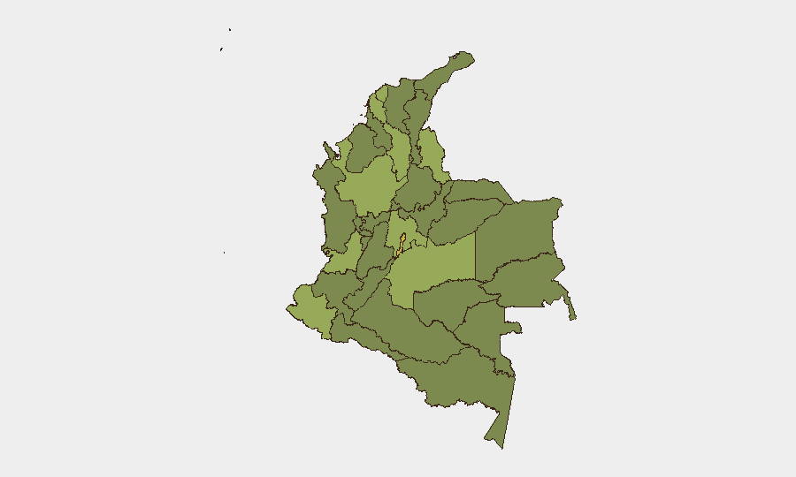
Colombia remains a moderately elevated threat environment (Global rank #32, composite score 63) characterized by persistent criminal and armed-group activity across multiple departments, coupled with recent signs of institutional strain. The Capital District (risk 66) and Meta Department (55.5) drive the highest composite risk scores, reflecting concentration of both urban crime and rural armed-group presence. Over the past 24–48 hours, available event signals suggest friction within government and security institutions—including arrests, command-level disputes, and disapprovals between civilian and military leadership—though specific incident details and Colombia-specific operational impacts remain limited in accessible open-source reporting.
Key Developments
Institutional tensions (2026-07-02, national scope): Multiple event signals on July 2 indicate discord within Colombian government and security structures, including a congressional disapproval directed at the presidency, a command-level rejection between military officers, and reduced relations reported between a colonel and military hierarchy. These signals, while non-kinetic, may affect interagency coordination and response capacity during operational incidents.
Law-enforcement activity (2026-07-02, jurisdiction unspecified): Arrest/detention events involving judicial and law-enforcement actors were recorded on July 2, and a prosecutor issued a public statement addressing a neighborhood-level matter. Specific locations and charges are not detailed in available signals.
Limited granular incident data (last 24–48h): Web research and open social-media sources did not yield Colombia-specific security incidents (armed-group activity, kidnapping, trafficking, protests, infrastructure disruption, or armed conflict) with confirmed timestamps within the past 48 hours. Older regional analyses and monthly forecasts are available but do not meet the recency threshold for actionable current developments.
Caveat: GeoBit's 260 tracked events and event-signal summary reflect aggregated monitoring; however, incident-level details (location, organization, victims, operational impact) are not visible in this briefing dataset. Security teams requiring real-time detail should cross-reference with Colombian official sources (MinDefensa, PoliciaColombia) and established outlets (El Tiempo, El Espectador, Semana).
Highest-Risk Areas
The Capital District (Bogotá metropolitan area) and Meta Department jointly account for the highest composite risk; Bogotá combines high urban-crime indices and protest activity, while Meta reflects persistent armed-group presence and territorial disputes in southern regions. Norte de Santander and Nariño departments along the Venezuelan and Ecuadorian borders add significant risk due to drug-trafficking routes, smuggling, and transnational criminal operations. Antioquia and Cundinamarca—historically volatile and currently hosting major urban centers and infrastructure—round out the top six. This clustering suggests that organizations with personnel or assets in Bogotá, the Meta region, or border departments (particularly norte-oriental and southwestern corridors) should maintain elevated monitoring and contingency protocols.
How GeoBit Would Assist
Security teams would use AOI Monitoring & Early Warning to establish persistent watches over high-risk departments (Meta, Norte de Santander, Nariño) and detect emerging armed-group, protest, or criminal activity before impact on operations. Intel Sweep and multi-language OSINT (X/Twitter, Telegram, local media feeds) provide 24/7 signal capture and sentiment analysis to identify institutional friction, resource constraints, or command disruptions that may degrade host-government response. Routing & Network Analysis enables real-time alternative-route planning for personnel movement and supply chains, bypassing active threat zones identified through conflict mapping and incident fusion.
7-Day Outlook
Institutional tensions and command-level friction may persist over the near term, potentially slowing inter-agency response to criminal and armed-group incidents. Ongoing activity in Meta, Norte de Santander, and border regions is expected to remain elevated. Organizations should maintain heightened vigilance and prepared contingency protocols, particularly for travel and outdoor operations in the Capital District and departments ranked in the top five.
Highest-Risk Areas — Ranked
| # | State / Region | Risk |
|---|---|---|
| 1 | Capital District | 66 |
| 2 | Meta Department | 55.5 |
| 3 | Norte de Santander Department | 54.9 |
| 4 | Nariño | 50.7 |
| 5 | Antioquia Department | 46.8 |
| 6 | Cundinamarca Department | 46.5 |
| 7 | Bolívar Department | 43.2 |
| 8 | Atlántico Department | 41.1 |
| 9 | Valle del Cauca Department | 40.4 |
| 10 | Vichada Department | 39.9 |
| 11 | Caquetá Department | 38.1 |
| 12 | Córdoba Department | 36.6 |
Sources
Previous Daily Briefs
A new Colombia brief is written every day — each with its own risk map and downloadable CSV. Here's the last week; use the calendar to go further back.
📅 Browse every day by calendar →
Highlighted days have a brief. Tap a day for that day's map & analysis, or “csv” for that day's dataset ($5).
Atlas — our AI intelligence desk — emails them this snapshot personally. Nothing else, no list.