Situation Summary
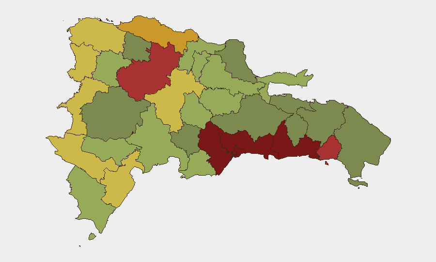
Dominican Republic remains a mid-range security environment with persistent street-level violence, armed robbery, and organized crime concentrated in urban centers. The composite threat score of 6 reflects a fragmented criminal landscape rather than state collapse or widespread conflict; however, sub-national variance is extreme, with Santo Domingo and the Nacional District posing material risk to corporate personnel and assets. Recent police operations suggest active enforcement posture, though the underlying drivers of violence (gang competition, drug trafficking, informal economies) remain structural.
Key Developments
- Santiago de los Caballeros, Santiago Province (2026-08-01/08-02): National Police arrested 13 individuals across multiple municipalities for alleged links to violence, robbery, illegal firearm possession, and currency forgery—indicating coordinated law-enforcement activity in the second-largest urban center.
- Santo Domingo, Plaza Castilla / Abraham Lincoln Avenue (2026-08-01, approximate): A fatal shooting occurred in a commercial establishment; victim died following police pursuit of the suspect, underscoring ongoing armed-crime risk in the capital's commercial districts.
- Baní, Peravia Province (date unconfirmed, recent): National Police arrested an individual in flagrante delicto for preparing to throw stones at vehicles on the Baní ring road, indicating traffic-disruption and mob-violence risks on provincial transport corridors.
- Broader Pattern (last 48 hours): Three separate GEOBIT event signals (Investigate, Disapprove toward US, Disapprove toward Lula da Silva) suggest diplomatic friction or internal political tension, though specifics remain under assessment.
Highest-Risk Areas
Santo Domingo (92) and the Nacional District (88) drive the country's risk profile—both are major commercial, financial, and government hubs where armed robbery, homicide, and gang activity concentrate. San Cristóbal, San Pedro de Macorís, and La Romana (scores 85, 83, 78) form a secondary urban cluster along the southern coast where organized-crime involvement in drug trafficking and port smuggling elevates risk. Santiago Province (76) is the second-largest metropolitan zone and shows sustained criminal activity. Border provinces (Elías Piña, Dajabón; scores 70, 68) and southern provinces (Barahona, Independencia; scores 65, 64) pose lower but non-negligible risks, primarily from contraband networks and informal commerce disruption.
How GeoBit Would Assist
Corporate security teams should deploy AOI (Area-of-Interest) Monitoring & Early Warning on high-risk municipalities (Santo Domingo, Santiago, San Pedro de Macorís) to track protest activity, police operations, and gang-related incidents in real time. OSINT fusion (X/Twitter, local police feeds, YouTube incident reporting) and Network & Actor Analysis would map criminal cells and trafficking corridors affecting supply chains and staff movement. Routing & Network Analysis enables identification of safe transit corridors and alternative routes around high-violence zones during travel or logistics operations.
7-Day Outlook
Police enforcement tempo appears elevated, suggesting cyclical crackdowns on organized crime rather than structural improvement; arrests are unlikely to reduce underlying violent-crime drivers. Diplomatic signals warrant monitoring for potential government instability or policy shifts affecting business-operating environment. Personnel in Santo Domingo, Santiago, and coastal commercial zones should maintain heightened situational awareness and restrict movement to daylight and secured corridors.
Highest-Risk Areas — Ranked
| # | State / Region | Risk |
|---|---|---|
| 1 | Santo Domingo | 92 |
| 2 | Nacional District | 88 |
| 3 | San Cristóbal | 85 |
| 4 | San Pedro de Macorís | 83 |
| 5 | La Romana | 78 |
| 6 | Santiago | 76 |
| 7 | Puerto Plata | 72 |
| 8 | Elías Piña | 70 |
| 9 | Dajabón | 68 |
| 10 | Barahona | 65 |
| 11 | Independencia Province | 64 |
| 12 | La Vega | 62 |
Sources
Previous Daily Briefs
A new Dominican Republic brief is written every day — each with its own risk map and downloadable CSV. Here's the last week; use the calendar to go further back.
📅 Browse every day by calendar →
Highlighted days have a brief. Tap a day for that day's map & analysis, or “csv” for that day's dataset ($5).
Atlas — our AI intelligence desk — emails them this snapshot personally. Nothing else, no list.