Situation Summary
Eritrea itself remains stable with no reported security incidents in the last 24–48 hours, but the country is now operationally enmeshed in renewed heavy fighting between Ethiopian federal forces and TPLF units in adjacent Western Tigray (Shererina area, August 1–3). Eritrean military involvement in support of Ethiopian federal operations—and alleged new troop deployments into Tigray—has been reported by regional sources, and Eritrea has reportedly closed airspace to Ethiopian Airlines in response to cross-border clashes. Risk to corporate assets and personnel in Eritrea remains indirect but elevated: spillover from the Tigray theater, aviation disruptions, and strained border management pose near-term duty-of-care concerns.
Key Developments
- Shererina, Western Tigray (Ethiopia–Sudan border), August 1–3: Heavy clashes between ENDF and TPLF forces involving artillery and drones resulted in hundreds of Tigrayan refugees and wounded fighters fleeing across the Sudan border; fighting is attributed in part to Eritrean military support for federal forces, directly implicating Eritrea's regional security posture.[15][17]
- Tigray–Eritrea operational axis, August 2: Regional sources (X/social media) report Eritrean military commanders entering Tigray and receiving support coordination from TPLF-affiliated networks, signaling active Eritrean force involvement beyond advisory roles; independent verification by major international outlets is pending.[11][12]
- Eritrea–Sudan airspace closure, reported August 2–3: Eritrea and Sudan have reportedly closed airspace to Ethiopian Airlines citing "hostility" following Shererina clashes; no official NOTAM or airline statement is yet publicly visible, but the reported restriction implies immediate aviation and travel disruptions affecting routes over or near Eritrean territory.[4][17]
- Ethiopia–Sudan refugee camps near Shererina, August 2–3: Artillery and drone fire during Shererina clashes impacted civilian and fighter displacement camps at the border; hundreds fled into Sudan, heightening humanitarian pressure and cross-border control strain that may extend to Eritrean borders.[15][17]
- Information and political tensions, late July–early August: Eritrea's information minister publicly accused Ethiopian state media of fabricating conflict narratives, responding to Ethiopian diplomatic assertions that TPLF operations are "led from Asmara"; this rhetoric escalation underscores mutual political-information pressure affecting perceptions of Eritrean stability.[6][9]
Highest-Risk Areas
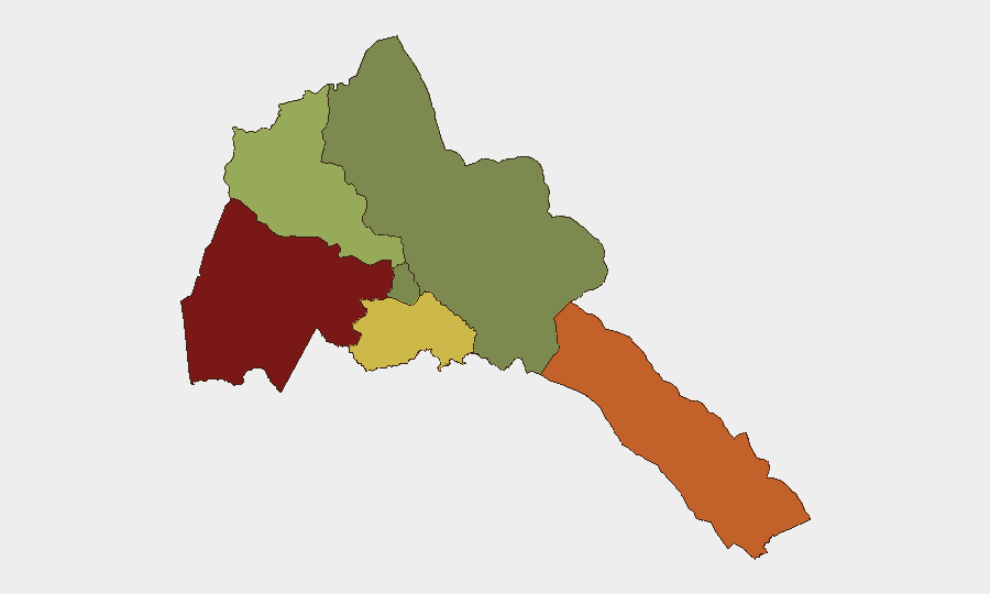
Gash-Barka (risk score 92) and Southern Red Sea Region (75) dominate Eritrea's sub-national threat profile, both lying along or near the Ethiopia–Eritrea border corridor where current Tigray-related fighting and alleged Eritrean troop movements are occurring. Debub Region (68) faces secondary spillover risk from the same axis. Maekel Region (18), where the capital Asmara is located, remains relatively low-risk on current data, though it is subject to aviation and economic secondary effects (airspace closure, supply-chain disruption) of regional conflict. The western and southern frontier zones are the primary concern for cross-border infiltration, displaced populations, and potential escalation of military operations.
How GeoBit Would Assist
Security teams should deploy AOI Monitoring & Early Warning on Eritrea's western and southern borders (Gash-Barka, Southern Red Sea) to detect refugee movement, military repositioning, or cross-border incursions in real time. Satellite & Imagery Analysis and Conflict & Military capabilities (force-structure tracking, battle mapping) would track Eritrean troop deployments into Tigray and any counter-mobilization by TPLF units. Aviation tracking and multi-language OSINT (X, Telegram, regional media) would confirm airspace closures, flight disruptions, and military-intelligence signals before they impact personnel travel or supply chains.
7-Day Outlook
The Shererina fighting is reported as a "cautious calm" as of August 3, but heavy weapons repositioning and Eritrean military buildup suggest sustained risk of renewed engagement over the next 7 days. Airspace restrictions and border-control pressure are likely to persist; corporate teams with travel or logistics dependencies should expect disruption to Ethiopian Airlines routes and increased scrutiny at Eritrean border checkpoints through mid-August. No evidence indicates imminent spillover into Eritrean territory, but sustained allied operations and refugee pressure merit daily monitoring.
Highest-Risk Areas — Ranked
| # | State / Region | Risk |
|---|---|---|
| 1 | Gash-Barka | 92 |
| 2 | Southern Red Sea Region | 75 |
| 3 | Debub Region | 68 |
| 4 | Anseba | 55 |
| 5 | Maekel Region | 18 |
| 6 | Northen Red Sea Region | 0 |
Sources
Previous Daily Briefs
A new Eritrea brief is written every day — each with its own risk map and downloadable CSV. Here's the last week; use the calendar to go further back.
📅 Browse every day by calendar →
Highlighted days have a brief. Tap a day for that day's map & analysis, or “csv” for that day's dataset ($5).
Atlas — our AI intelligence desk — emails them this snapshot personally. Nothing else, no list.