Situation Summary
Fiji remains stable with no acute conflict, large-scale civil unrest, or political instability as of 26 August 2026. The country ranks #66 globally (composite threat score 28) with routine crime concentrated in urban and peri-urban areas of the Western and Central divisions. Current security activity is dominated by a scheduled counter-terrorism military exercise (Exercise Bougainville) and isolated incidents of street robbery, neither of which signals systemic deterioration. The overall trajectory remains low-risk, though localized property crime and transport-sector vulnerability warrant continued monitoring.
Key Developments
- Nadi taxi robbery (Western Division, 25 August, 9am). Three men and a woman robbed a Solovi-based taxi driver of FJD $40 and a mobile phone (approx. $1,400); incident was video-recorded and circulated on social media. One suspect (23-year-old male) surrendered voluntarily; two additional arrests made; police investigation ongoing for remaining suspects.
- Exercise Bougainville counter-terrorism phase (Western Division, 16–24 August, reported 25–26 August). The Republic of Fiji Military Forces conducted a brigade-level field training drill (DEPCON 4) simulating counter-terrorism response across Nadi, interior areas, Nadi Airport, water supply infrastructure, and fuel depots, with inter-agency vehicle checkpoints. Exercise is scheduled through 28 August and is assessed as routine training, not response to an actual threat.
- Teachers' march for improved pay and conditions (Suva, 25 August). Fijian Teachers Association members, active and retired teachers conducted a peaceful, organized march demanding better compensation and working conditions. No arrests, clashes, or security force intervention reported.
- Residential house fire in Ba (Western Division, reported 26 August). A family evacuated safely; home destroyed. Cause under investigation by the National Fire Authority; no indication of arson or broader disorder.
- Policy response to transport-sector crime (national, 26 August). Opposition leader Inia Seruiratu called for installation of in-vehicle cameras in taxis and expansion of digital booking technology to enhance driver safety, directly referencing the Nadi robbery case and broader taxi driver vulnerability.
- Nadi–Lautoka corridor military exercise traffic disruption (Western Division, 22–28 August, status as of 26 August). Ongoing Exercise Bougainville field phase causing localized traffic congestion and noise; assessed as posing no security threat or sign of instability.
Highest-Risk Areas
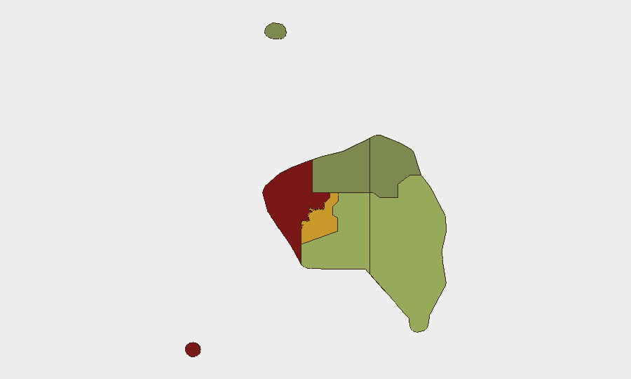
The Western Division (risk score 85) and Central Division (risk score 72) account for the vast majority of Fiji's composite threat exposure, driven by concentration of urban and peri-urban property crime, armed robbery, and burglary in commercial and residential zones. Nadi and Lautoka corridors within the Western Division show particular vulnerability to street robbery and transport-sector crime, as evidenced by the 25 August taxi robbery and historical incident patterns. Eastern Division (risk 45) and Northern Division (risk 38) show substantially lower risk profiles, while Rotuma (risk 12) remains minimal. Routine crime rather than political or conflict-related instability is the primary driver of Western and Central risk scores.
How GeoBit Would Assist
Security teams operating personnel or assets in Fiji should deploy AOI Monitoring & Early Warning on high-risk urban zones (Nadi, Lautoka, Suva) to track emerging robbery, burglary, and transport-sector incidents in real time. OSINT fusion and multi-language social media analysis (X/Twitter, YouTube, local news feeds) would corroborate street-level crime patterns and identify emerging threats faster than official reporting. Risk & Threat Assessment integrated with GIS & Spatial Analysis enables duty-of-care teams to map safe routing, identify corridor vulnerabilities, and adjust travel protocols dynamically.
7-Day Outlook
Exercise Bougainville will conclude by 28 August, removing the temporary military presence and traffic disruption from the Nadi–Lautoka corridor. No indicators suggest escalation of crime, political tension, or civil unrest in the near term. Routine property crime and targeted transport-sector robbery are likely to persist in Western and Central urban zones; organizations should maintain heightened situational awareness for staff mobility and asset protection through early September.
Highest-Risk Areas — Ranked
| # | State / Region | Risk |
|---|---|---|
| 1 | Western | 85 |
| 2 | Central | 72 |
| 3 | Eastern | 45 |
| 4 | Northern | 38 |
| 5 | Rotuma | 12 |
Sources
Previous Daily Briefs
A new Fiji brief is written every day — each with its own risk map and downloadable CSV. Here's the last week; use the calendar to go further back.
- August 25, 2026
- August 24, 2026
- August 23, 2026
- August 21, 2026
- August 20, 2026
- August 18, 2026
- August 17, 2026
📅 Browse every day by calendar →
Highlighted days have a brief. Tap a day for that day's map & analysis, or “csv” for that day's dataset ($5).
Atlas — our AI intelligence desk — emails them this snapshot personally. Nothing else, no list.