Situation Summary
Iraq remains at elevated risk (rank #15 globally, composite score 93) as large-scale anti-corruption security operations coincide with a politically significant disarmament deadline for Iran-aligned armed groups and renewed regional military activity involving missiles and drones. Overnight raids in Baghdad on June 29–30 resulted in the arrest of approximately 47 lawmakers and senior officials, triggering deployment of elite Counter Terrorism Service units across the Green Zone and government compounds. The convergence of internal political upheaval, external military strikes, and organized-crime activity in southern and central governorates signals a period of heightened volatility and operational uncertainty for personnel and assets across the country.
Key Developments
- Baghdad Green Zone | June 29–30 (overnight): Iraqi Counter Terrorism Service and security forces conducted large-scale coordinated raids, detaining approximately 47 lawmakers, politicians, and senior officials on suspected corruption charges related to the previous administration. Armoured vehicles and heavy units deployed around government and diplomatic compounds near the U.S. Embassy, prompting initial speculation of a coup; analysts assess the activity as an aggressive internal anti-corruption operation within constitutional authority.
- Baghdad – Multiple locations | June 30 (morning): Security forces sealed the Green Zone from late Saturday into early Sunday, imposing significant movement restrictions. Videos confirmed deployment of special forces at key government and diplomatic sites.
- National | June 29 announcement: Government spokesman Haidar al-Aboudi announced a September 30 deadline for all pro-Iran armed groups to disarm, coinciding with the planned end of the U.S.-led anti-IS coalition mission. The statement underscores heightened political tension with armed factions and signals potential friction as the deadline approaches.
- Iraq – Nationwide airspace | June 29–30: Foreign government travel advisories warn that missiles, drones, and projectiles have recently struck targets in Iraq as part of wider regional military activity. Short-notice strikes pose risk of sudden flight cancellations and broader travel disruption.
- Southern and central Iraq | Late June 29–30: International advisories reiterate sustained activity by organized criminal groups, with frequent armed clashes between rival tribes, militias, and security forces. Regular kidnappings, road attacks, and sporadic curfews impose high baseline risk for overland travel and urban movement.
Highest-Risk Areas
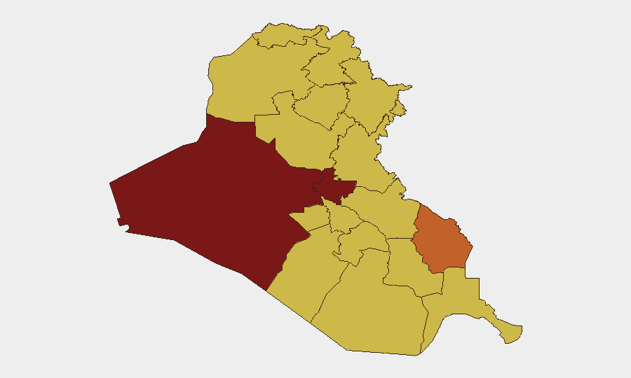
Baghdad Governorate (95.4) and Al-Anbar Governorate (91) dominate the risk profile, driven by the ongoing anti-corruption operations, heavy security-force deployment, and proximity to conflict zones. Maysan Governorate (75.9) ranks third due to exposure to organized-crime networks and militia activity. The remaining nine governorates cluster at 65.4, reflecting persistent baseline risks from criminal organization activity, tribal and militia clashes, and occasional military operations, with particular concern in southern provinces (Basra, Dhi Qar, Al-Muthanna) where kidnapping and road attacks remain routine.
How GeoBit Would Assist
Security teams would deploy AOI Monitoring & Early Warning on Baghdad's Green Zone and other key compound locations to detect sudden deployment of heavy units and security cordons in real time. Intel Sweep and OSINT fusion across X/Twitter, Telegram, and local Iraqi media would corroborate reports of arrests, detainee movements, and political statements, reducing reliance on unverified social-media rumors. Routing & Network Analysis would support journey planning around curfew zones and armed-clash hotspots, particularly in southern governorates, while Event feed and sentiment analysis tracks the trajectory of the September 30 disarmament deadline and militia positioning.
7-Day Outlook
The anti-corruption campaign is likely to continue with additional arrests and possible detention of mid-level officials, sustaining restricted movement in Baghdad through early July. Regional military activity and the September 30 deadline will likely generate further political statements and militia posturing, increasing the risk of sudden escalation. Overland travel in southern and central Iraq should be assumed high-risk; flight schedules remain subject to cancellation on short notice.
Highest-Risk Areas — Ranked
| # | State / Region | Risk |
|---|---|---|
| 1 | Baghdad Governorate | 95.4 |
| 2 | Al-Anbar Governorate | 91 |
| 3 | Maysan Governorate | 75.9 |
| 4 | Babil Governorate | 65.4 |
| 5 | Wasit Governorate | 65.4 |
| 6 | Al-Qadisiyah Governorate | 65.4 |
| 7 | Dhi Qar Governorate | 65.4 |
| 8 | Al-Muthanna Governorate | 65.4 |
| 9 | Al-Basra Governorate | 65.4 |
| 10 | Al-Najaf Governorate | 65.4 |
| 11 | Saladin Governorate | 65.4 |
| 12 | Erbil Governorate | 65.4 |
Sources
Previous Daily Briefs
A new Iraq brief is written every day — each with its own risk map and downloadable CSV. Here's the last week; use the calendar to go further back.
📅 Browse every day by calendar →
Highlighted days have a brief. Tap a day for that day's map & analysis, or “csv” for that day's dataset ($5).